FAA INFORMATION EFFECTIVE 10 JULY 2025
Location
| FAA Identifier: | OGG |
| Lat/Long: | 20-53-55.1350N 156-25-49.6510W
20-53.918917N 156-25.827517W
20.8986486,-156.4304586
(estimated) |
| Elevation: | 55.4 ft. / 16.9 m (surveyed) |
| Variation: | 11E (1990) |
| From city: | 3 miles E of KAHULUI, HI |
| Time zone: | UTC -10 (year round; does not observe DST) |
| Zip code: | 96732 |
Airport Operations
| Airport use: | Open to the public |
| Activation date: | 10/1946 |
| Control tower: | yes |
| ARTCC: | HONOLULU CONTROL FACILITY CENTER |
| FSS: | HONOLULU FLIGHT SERVICE STATION |
| NOTAMs facility: | OGG (NOTAM-D service available) |
| Attendance: | CONTINUOUS |
| Wind indicator: | yes |
| Segmented circle: | yes |
| Lights: | WHEN ATCT CLSD ACTVT MALSR RWY 02; PAPI RWY 20; PAPI RWY 05; HIRL RWY 02/20; MIRL RWY 05/23 - CTAF. |
| Beacon: | white-green (lighted land airport)
Operates sunset to sunrise. |
| Fire and rescue: | ARFF index D |
| Airline operations: | INDEX D ARPT; HWVR, CAN ACCOMMODATE INDEX E AS RQRD. CALL AMGR PRIOR TO ARR. |
| International operations: | customs landing rights airport |
Airport Communications
| CTAF: | 118.7 |
| UNICOM: | 122.95 |
| ATIS: | 128.6 |
| WX ASOS: | PHONE 808-877-6282 |
| MAUI GROUND: | 121.9 279.6 [0600-2300 (MAR-NOV) 0600-2400 (NOV-MAR)] |
| MAUI TOWER: | 118.7 279.6 [0600-2300 (MAR-NOV) 0600-2400 (NOV-MAR)] |
| HCF APPROACH APPROACH: | 119.5 ;SOUTH 120.2 ;NORTH 225.4 ;SOUTH 322.4 ;NORTH [0600-2300 (MAR-NOV) 0600-2400 (NOV-MAR)] |
| HCF APPROACH DEPARTURE: | 119.5 ;SOUTH 120.2 ;NORTH 225.4 ;SOUTH 322.4 ;NORTH [0600-2300 (MAR-NOV) 0600-2400 (NOV-MAR)] |
| CLEARANCE DELIVERY: | 120.6 290.5 |
| CLASS C: | 119.5 ;SOUTH 120.2 ;NORTH 225.4 ;SOUTH 322.4 ;NORTH |
| EMERG: | 121.5 243.0 |
| IC: | 119.5 ;SOUTH 120.2 ;NORTH 225.4 ;SOUTH 322.4 ;NORTH |
| WX AWOS-3PT at JHM (14 nm W): | 118.525 (808-665-6101) |
- APCH/DEP SVC PRVDD BY HONOLULU CONTROL FACILITY (ZHN) ON FREQ 119.3 & 307.1 (MOUNT HALEAKALA RCAG) WHEN OGG TWR CLSD.
- IFR TFC ON THE GROUND CTC HONOLULU CONTROL FACILITY ON 119.3 0900-1600Z, EFFECTIVE STARTING AT 0200 LOCAL TIME THE SECOND SUNDAY IN MARCH THROUGH 0200 LOCAL TIME THE FIRST SUNDAY IN NOVEMBER AND 1000Z-1600Z, EFFECTIVE STARTING AT 0200 LOCAL TIME THE FIRST SUNDAY IN NOVEMBER THROUGH 0200 LOCAL TIME THE SECOND SUNDAY IN MARCH). ALL TFC IS REQUESTED TO FOLLOW THE PROCEDURES DESCRIBED FOR TRAFFIC ADVISORIES AT NON-TOWER AIRPORTS UNDER AREA NOTICES EXCEPT TO UTILIZE MAUI TOWER FREQ 118.7 INSTEAD OF 122.9
- 0600-2300, EFFECTIVE STARTING AT 0200 ON THE SECOND SUNDAY IN MARCH THROUGH 0200 ON THE FIRST SUNDAY IN NOVEMBER. 0600-2400, EFFECTIVE STARTING AT 0200 ON THE FIRST SUNDAY IN NOVEMBER THROUGH 0200 ON THE SECOND SUNDAY IN MARCH.
Nearby radio navigation aids
| VOR radial/distance | | VOR name | | Freq | | Var |
|---|
| OGG at field | | MAUI VORTAC | | 115.10 | | 11E |
| LNYr064/31.2 | | LANAI VORTAC | | 117.70 | | 11E |
Airport Services
| Fuel available: | 100 JET-A
100:JET A FUEL AVBL 0700-1800, OTHER TIMES BY PRIOR ARRANGEMENT WITH FBO 24 HRS, (808) 871-5572, OR (808) 873-6060. 100 OCTANE FUEL AVBL 24 HOURS SELF-SERVICE. |
| Parking: | tiedowns |
| Airframe service: | MINOR |
| Powerplant service: | MINOR |
| Bottled oxygen: | NONE |
| Bulk oxygen: | NONE |
Runway Information
Runway 2/20
| Dimensions: | 6998 x 150 ft. / 2133 x 46 m |
| Surface: | asphalt/grooved, in good condition |
| Weight bearing capacity: | | Single wheel: | 130.0 | | Double wheel: | 170.0 | | Double tandem: | 360.0 | | Dual double tandem: | 750.0 |
|
| Runway edge lights: | high intensity |
| RUNWAY 2 | | RUNWAY 20 |
| Latitude: | 20-53.348430N | | 20-54.295648N |
| Longitude: | 156-26.179162W | | 156-25.474072W |
| Elevation: | 55.3 ft. | | 14.3 ft. |
| Traffic pattern: | right | | left |
| Runway heading: | 024 magnetic, 035 true | | 204 magnetic, 215 true |
| Declared distances: | TORA:6995 TODA:6995 ASDA:6995 LDA:6995 | | TORA:6995 TODA:6995 ASDA:6995 LDA:6995 |
| Markings: | precision, in good condition | | precision, in good condition |
| Visual slope indicator: | 4-light PAPI on right (3.00 degrees glide path) | | 4-light PAPI on left (3.00 degrees glide path) |
| Approach lights: | MALSR: 1,400 foot medium intensity approach lighting system with runway alignment indicator lights | | |
| Touchdown point: | yes, no lights | | yes, no lights |
| Instrument approach: | ILS/DME | | |
| Obstructions: | 198 ft. stack, lighted, 9704 ft. from runway, 500 ft. left of centerline, 48:1 slope to clear | | 5 ft. bldg, marked, 300 ft. from runway, 250 ft. left of centerline, 20:1 slope to clear
HIGH TREES 600 FT NW CNTRLN EXTDD RY 20. |
Runway 5/23
| Dimensions: | 4980 x 150 ft. / 1518 x 46 m |
| Surface: | asphalt/grooved, in good condition |
| Weight bearing capacity: | | Single wheel: | 130.0 | | Double wheel: | 170.0 | | Double tandem: | 270.0 |
|
| Runway edge lights: | medium intensity |
| RUNWAY 5 | | RUNWAY 23 |
| Latitude: | 20-53.881608N | | 20-54.228592N |
| Longitude: | 156-26.225350W | | 156-25.432133W |
| Elevation: | 22.1 ft. | | 17.6 ft. |
| Traffic pattern: | left | | right |
| Runway heading: | 054 magnetic, 065 true | | 234 magnetic, 245 true |
| Markings: | nonprecision, in good condition | | nonprecision, in good condition |
| Visual slope indicator: | 4-light PAPI on left (3.00 degrees glide path)
PAPI UNUSBL BYD 4 NM FM THR DUE TO RAPIDLY RISING TERRAIN. | | |
| Touchdown point: | yes, no lights | | yes, no lights |
| Obstructions: | 31 ft. trees, 1200 ft. from runway, 28:1 slope to clear
+6 FT EXTNDD GND 200 FT FM THLD & 220 FT EACH SIDE CNTRLN; +32 FT LGTD WINDSOCK 0 FT FM THLD & 230 FT SE OF CNTRLN. | | 35 ft. pole, 1500 ft. from runway, 37:1 slope to clear |
Helipad H1
| Dimensions: | 125 x 125 ft. / 38 x 38 m |
| Surface: | asphalt, in good condition |
| Latitude: | 20-53.340833N | | |
| Longitude: | 156-26.032333W | | |
| Elevation: | 49.0 ft. | | |
| Traffic pattern: | left | | left |
Airport Ownership and Management from official FAA records
| Ownership: | Publicly-owned |
| Owner: | HAWAII STATE AIRPORTS DIV
HONOLULU INTL ARPT
HONOLULU, HI 96819
Phone 808-838-8600 |
| Manager: | MARVIN MONIZ
1 KAHULUI AIRPORT ROAD, UNIT 5
KAHULUI, HI 96732
Phone 808-872-3808
MARVIN.A.MONIZ@HAWAII.GOV |
Additional Remarks
| A39-05/23 | PCR VALUE: 670/F/A/X/T |
| A39-02/20 | PCR VALUE: 480/F/D/X/T |
| - | 570' LGTD TWR APRX 3 MI. W. |
| - | PPR FOR FIXED WING ACFT OPNS ON HELIPAD DURG NON-OPERATIONAL HRS CALL (808) 872-3880 5:15A-10:00P. |
| - | ACCESS TO HELIPAD FM TWY C ONLY. |
| - | DUE TO NONVISIBILITY ATCT UNABLE TO DETERMINE IF FLWG AREA IS CLEAR OF OBSTNS AND/OR TFC: PORTION OF TWY F BTN THE COMMUTER AIR TERMINAL & APCH END RY 05. |
| - | DUE TO NONVISIBILITY ATCT UNABLE TO PROVIDE ATC SVC BTN ACFT & GROUND VEHICLES ON THE COMMUTER AIR TERMINAL S OF TWY F AND THE HELICOPTER AIR TERMINAL E OF APCH END RY 02. |
| - | TSNT PARKING LCTD ON NE SECTION OF E RAMP. |
| - | RY 02/20 SINGLE-BELLY TWIN TANDEM (SBTT) GWT 460,000 LBS. |
| - | 24 HRS PPR FOR DIVISION 1.1,1.2,1.3 EXPLOSIVES AND 4 HRS PPR FOR OTHER HAZARDOUS CARGO IN/OUT OF ARPT; CTC (808) 872-3830 0745-1630 OTHER TIMES (808) 872-3888. |
| - | ACFT OVR 30,000 LB LDG ON RY 02/20 UNA TO TURN OFF ONTO RY 05/23 DUE TO PAVEMENT COND. |
| - | COMMUTER AIR TRML RSTRD TO PART 121 AND PART 135 OPRS ONLY. ACFT AT THE TRML SHALL CALL THE TWR ON 121.9 PRIOR TO PUSHBACK. |
| - | FOR CD WHEN ATCT IS CLSD CTC HONOLULU CONTROL FACILITY AT 808-840-6262. |
| - | RAMP AREA E SIDE RY 02 UNDER STATE AUTHORITY. FAA NOT RESPONSIBLE FOR DIRECTION & CTL GND TFC IN AREA. |
| - | MIGRATORY BIRD ACTIVITY BLO 1500 FT WI 5 NM RADIUS OF ARPT DURG AUG-MAY. |
| - | MIL HEL OPS WITH PPR RSTRD TO THE SW CORNER OF HOT CARGO APRON (HAZMAT) N OF RWY 05/23. |
| - | COMMUTER TERMINAL RAMP RESTRICTED TO ACFT 140000 LBS OR LESS. |
| - | AREA E OF APCH END RY 02 DESIGNATED AS HELICOPTER OPER AREA. NO FIXED WING ACFT MAY OPER ON HELIPAD DURG OPNL HRS SR-SS. |
Instrument Procedures
NOTE: All procedures below are presented as PDF files. If you need a reader for these files, you should download the free Adobe Reader.NOT FOR NAVIGATION. Please procure official charts for flight.
FAA instrument procedures published for use from 10 July 2025 at 0901Z to 07 August 2025 at 0900z.
STARs - Standard Terminal Arrivals |
|---|
| CAMPS FOUR | |
download (151KB) |
| LAVAS ONE (RNAV) | |
download (195KB) |
| LNDHY ONE (RNAV) | |
download (199KB) |
IAPs - Instrument Approach Procedures |
|---|
| ILS Y OR LOC Y RWY 02 | |
download (363KB) |
| ILS Z OR LOC Z RWY 02 | |
download (383KB) |
| RNAV (RNP) Z RWY 02 | |
download (309KB) |
| RNAV (GPS) RWY 20 | |
download (302KB) |
| RNAV (GPS) RWY 23 | |
download (303KB) |
| RNAV (GPS) Y RWY 02 | |
download (311KB) |
| VOR Z OR TACAN RWY 20 | |
download (329KB) |
| SMOKE STACK VISUAL RWY 02 | |
download (187KB) |
| NOTE: Special Alternate Minimums apply | |
download (148KB) |
Departure Procedures |
|---|
| BEACH FOUR | |
download (193KB) |
| HIAKA ONE (RNAV) | |
download (261KB) |
| MAUI FIVE | |
download (183KB) |
| NPLII TWO (RNAV) | |
download (152KB) |
| ONOHI TWO | |
download (195KB) |
| PUHEE ONE (RNAV) | |
download (290KB) |
| STACEY TWO | |
download (214KB) |
| SWEEP TWO | |
download (184KB) |
| NOTE: Special Take-Off Minimums/Departure Procedures apply | |
download |
Other nearby airports with instrument procedures:
PHHN - Hana Airport (24 nm E)
PHNY - Lanai Airport (30 nm W)
PHLU - Kalaupapa Airport (36 nm NW)
PHMK - Molokai Airport (40 nm W)
PHMU - Waimea-Kohala Airport (69 nm SE)
|
|

Road maps at:
MapQuest
Bing
Google
| Aerial photo |
|---|
WARNING: Photo may not be current or correct
 Photo by Charles K. Morris, South Ramp Solutions LLC
Photo taken 09-Sep-2006
from a Vans RV-8
Photo by Charles K. Morris, South Ramp Solutions LLC
Photo taken 09-Sep-2006
from a Vans RV-8
Do you have a better or more recent aerial photo of Kahului Airport that you would like to share? If so, please send us your photo.
|
| Sectional chart |
|---|
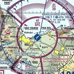
|
CAUTION: Diagram may not be current
 Download PDF
of official airport diagram from the FAA
| Airport distance calculator |
|---|
|
|
| Sunrise and sunset |
|---|
|
Times for 03-Aug-2025
| | Local
(UTC-10) | | Zulu
(UTC) |
|---|
| Morning civil twilight | | 05:38 | | 15:38 |
| Sunrise | | 06:02 | | 16:02 |
| Sunset | | 19:02 | | 05:02 |
| Evening civil twilight | | 19:26 | | 05:26 |
|
| Current date and time |
|---|
| Zulu (UTC) | 04-Aug-2025 06:16:34 |
|---|
| Local (UTC-10) | 03-Aug-2025 20:16:34 |
|---|
|
| METAR |
|---|
| PHOG | 040554Z 04012G24KT 10SM SCT050 26/19 A3005 RMK AO2 PK WND 06026/0506 SLP181 T02610194 10311 20261 53025 $
|
|
| TAF |
|---|
| PHOG | 031736Z 0318/0418 04016G25KT P6SM FEW030 SCT045 FM031900 05024G33KT P6SM FEW030 SCT050 FM040500 05017G25KT P6SM FEW030 SCT045 FM041000 05012G18KT P6SM FEW030 SCT045
|
PHJH
13nm NW | 031736Z 0318/0418 03017KT P6SM FEW030 SCT045 FM032100 05022KT P6SM FEW030 SCT050 FM040500 05012KT P6SM FEW030 SCT045
|
|
| NOTAMs |
|---|
NOTAMs are issued by the DoD/FAA and will open in a separate window not controlled by AirNav.
|
|


