FAA INFORMATION EFFECTIVE 14 MAY 2026
Location
| FAA Identifier: | OTZ |
| Lat/Long: | 66-53-05.3000N 162-35-53.3000W
66-53.088333N 162-35.888333W
66.8848056,-162.5981389
(estimated) |
| Elevation: | 15.4 ft. / 4.7 m (surveyed) |
| Variation: | 11E (2020) |
| From city: | 1 mile S of KOTZEBUE, AK |
| Time zone: | UTC -8 (UTC -9 during Standard Time) |
| Zip code: | 99752 |
Airport Operations
| Airport use: | Open to the public |
| Activation date: | 09/1947 |
| Control tower: | no |
| ARTCC: | ANCHORAGE CENTER |
| FSS: | KOTZEBUE FLIGHT SERVICE STATION (on field) [907-442-3310] |
| Alternate FSS: | FAI FAIRBANKS FLIGHT SERVICE STATION [1-866-248-6516] |
| NOTAMs facility: | OTZ (NOTAM-D service available) |
| Attendance: | WED-MON 0700-1900 |
| Wind indicator: | lighted |
| Segmented circle: | yes |
| Lights: | ACTVT REIL RWY 09 & 27 - CTAF. HIRL RWY 09/27; MIRL RWY 18/36 ON 0700-2400; OTR TIME - CTAF. PAPI RWY 09 & 27 ON CONSLY. |
| Beacon: | white-green (lighted land airport)
Operates sunset to sunrise. |
| Fire and rescue: | ARFF index B |
| Airline operations: | CLSD TO ACR OPS MORE THAN 30 PAX SEATS EXC PPR IN WRITING - AMGR BOX 55 KOTZEBUE AK 99752. |
Airport Communications
| CTAF: | 123.6 |
| UNICOM: | 122.8 |
| WX ASOS: | 135.45 (907-931-5182) |
- APCH/DEP SVC PRVDD BY ANCHORAGE ARTCC ON FREQS 119.2/263.0 (KOTZEBUE RCAG).
- OTZ AFIS ON FREQUENCY 135.45. OPERATES SAME HRS AS OTZ FSS, 0700-0000; OT FAIRBANKS FSS.
- COMMUNICATIONS PRVDD BY KOTZEBUE FSS ON FREQ 123.6 (CTAF).
Nearby radio navigation aids
| VOR radial/distance | | VOR name | | Freq | | Var |
|---|
| OTZr253/1.4 | | KOTZEBUE VOR/DME | | 115.70 | | 15E |
| NDB name | | Hdg/Dist | | Freq | | Var | | ID |
|---|
| HOTHAM | | 208/1.3 | | 356 | | 11E | | HHM | .... .... -- |
Airport Services
| Fuel available: | 100 JET-A |
| Parking: | hangars |
| Airframe service: | MINOR |
| Powerplant service: | MINOR |
Runway Information
Runway 9/27
| Dimensions: | 6300 x 150 ft. / 1920 x 46 m |
| Surface: | asphalt/grooved, in good condition |
| Weight bearing capacity: | | Single wheel: | 100.0 | | Double wheel: | 128.0 | | Double tandem: | 240.0 |
|
| Runway edge lights: | high intensity |
| Operational restrictions: | SAFETY AREA NON STD. LOCKED WHEEL TURNS NA. |
| RUNWAY 9 | | RUNWAY 27 |
| Latitude: | 66-53.372875N | | 66-53.161648N |
| Longitude: | 162-36.642670W | | 162-34.068962W |
| Elevation: | 12.8 ft. | | 15.4 ft. |
| Traffic pattern: | left | | left |
| Runway heading: | 091 magnetic, 102 true | | 271 magnetic, 282 true |
| Displaced threshold: | 400 ft. | | no |
| Declared distances: | TORA:6300 TODA:6300 ASDA:6300 LDA:5900 | | TORA:5900 TODA:5900 ASDA:5900 LDA:5900 |
| Markings: | precision, in fair condition | | nonprecision, in fair condition |
| Visual slope indicator: | 4-light PAPI on right (3.00 degrees glide path) | | 4-light PAPI on left (3.30 degrees glide path) |
| RVR equipment: | touchdown | | rollout |
| Runway end identifier lights: | yes | | yes |
| Touchdown point: | yes, no lights | | yes, no lights |
| Instrument approach: | ILS/DME | | |
| Obstructions: | 15 ft. road, 30 ft. from runway
ROAD 430 FT FM THR; VEHICLE HGT LTD TO 13 FT. | | 38 ft. hill, 800 ft. from runway, 15:1 slope to clear |
Runway 18/36
| Dimensions: | 3876 x 90 ft. / 1181 x 27 m |
| Surface: | gravel, in fair condition |
| Runway edge lights: | medium intensity |
| Operational restrictions: | ACR OPS MORE THAN 30 PAX SEATS NA. WINGSPAN GTR THAN 49 FT PPR - AMGR. UNCTLD VEHICLE ACES. |
| RUNWAY 18 | | RUNWAY 36 |
| Latitude: | 66-53.106398N | | 66-52.489467N |
| Longitude: | 162-36.559432W | | 162-36.948197W |
| Elevation: | 11.2 ft. | | 10.8 ft. |
| Traffic pattern: | left | | left |
| Runway heading: | 183 magnetic, 194 true | | 003 magnetic, 014 true |
| Touchdown point: | yes, no lights | | yes, no lights |
| Obstructions: | 15 ft. road, 400 ft. from runway, 26:1 slope to clear | | none |
Airport Ownership and Management from official FAA records
| Ownership: | Publicly-owned |
| Owner: | ALASKA DOT&PF NORTHERN REGION
2301 PEGER RD
FAIRBANKS, AK 99701
Phone 907-451-2200 |
| Manager: | ANDREW GREENE
BOX 55
KOTZEBUE, AK 99752
Phone 907-442-3147 |
Additional Remarks
| A39-09/27 | PCR VALUE: 713/F/B/X/T |
| A30A-09 | IREG SFC 1175 FT E OF THR. |
| - | NMRS 330 FT WIND TURBINE TWRS 3.5 MI SE. |
| - | WX CAMERA AVBL ON INTERNET AT HTTPS://WEATHERCAMS.FAA.GOV |
| - | BIRDS & WATERFOWL INVOF ARPT. |
| - | TSA REGULATED: SEE 49 CFR 1542; ALL GATES & DOORS SECURED ALL TIMES; INFO - AMGR. |
| - | IREG SFC TWY E 175 FT SW. |
| - | FUEL SVC - 907-412-0775. |
| - | RWY, TWY & RAMP EDGE LGTS EXTD 30 IN ABV GND. |
| - | ARPT SVCS AVBL 0700-2000; AFT HR - AMGR. |
| - | PRKG AREA UNLGTD. TSNT PRKG - FLT SVC. |
| - | TWYS & RAMPS HAVE NMRS DIPS & ROUGH SFCS. |
| - | SAND LRGR GRADATION THAN FAA RCMDD/SEE AC150/5200-30. |
Instrument Procedures
NOTE: All procedures below are presented as PDF files. If you need a reader for these files, you should download the free Adobe Reader.NOT FOR NAVIGATION. Please procure official charts for flight.
FAA instrument procedures published for use from 14 May 2026 at 0901Z to 11 June 2026 at 0900Z.
IAPs - Instrument Approach Procedures |
|---|
| ILS OR LOC RWY 09 | |
download (302KB) |
| RNAV (GPS) RWY 09 | |
download (257KB) |
| RNAV (GPS) RWY 27 | |
download (223KB) |
| VOR RWY 09 | |
download (270KB) |
| VOR RWY 27 | |
download (223KB) |
| NOTE: Special Alternate Minimums apply | |
download (147KB) |
| NOTE: Special Take-Off Minimums/Departure Procedures apply | |
download (405KB) |
Other nearby airports with instrument procedures:
PFNO - Robert (Bob) Curtis Memorial Airport (37 nm E)
PAWN - Noatak Airport (42 nm N)
PADE - Deering Airport (49 nm S)
PAIK - Bob Baker Memorial Airport (51 nm E)
PASK - Selawik Airport (64 nm E)
|
|

Road maps at:
MapQuest
Bing
Google
| Aerial photo |
|---|
WARNING: Photo may not be current or correct
 Taken in March 2008
Frontier Flying Services flight 8924 on short final to runway 9
Taken in March 2008
Frontier Flying Services flight 8924 on short final to runway 9
Do you have a better or more recent aerial photo of Ralph Wien Memorial Airport that you would like to share? If so, please send us your photo.
|
| Sectional chart |
|---|
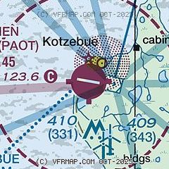
|
| Airport distance calculator |
|---|
|
|
| Sunrise and sunset |
|---|
|
Times for 25-May-2026
| | Local
(UTC-8) | | Zulu
(UTC) |
|---|
| Morning civil twilight | | + | | + |
| Sunrise | | 04:08 | | 12:08 |
| Sunset | | 01:27 | | 09:27 |
| Evening civil twilight | | + | | + |
|
| Current date and time |
|---|
| Zulu (UTC) | 26-May-2026 06:33:51 |
|---|
| Local (UTC-8) | 25-May-2026 22:33:51 |
|---|
|
| METAR |
|---|
| PAOT | 260553Z AUTO 00000KT 10SM CLR 04/01 A2943 RMK AO2 SLP967 T00440006 10067 20011 56026 TSNO $
|
|
| TAF |
|---|
| PAOT | 260538Z 2606/2706 02010KT P6SM SCT060 BKN150
|
|
| NOTAMs |
|---|
NOTAMs are issued by the DoD/FAA and will open in a separate window not controlled by AirNav.
|
|

