FAA INFORMATION EFFECTIVE 14 MAY 2026
Location
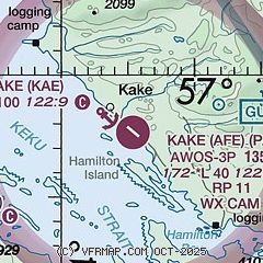
| FAA Identifier: | AFE |
| Lat/Long: | 56-57-40.9050N 133-54-36.9400W
56-57.681750N 133-54.615667W
56.9613625,-133.9102611
(estimated) |
| Elevation: | 171.5 ft. / 52 m (estimated) |
| Variation: | 21E (2010) |
| From city: | 1 mile SE of KAKE, AK |
| Time zone: | UTC -8 (UTC -9 during Standard Time) |
| Zip code: | 99830 |
Airport Operations
| Airport use: | Open to the public |
| Activation date: | 11/1986 |
| Control tower: | no |
| ARTCC: | ANCHORAGE CENTER |
| FSS: | SITKA FLIGHT SERVICE STATION [907-966-2221] |
| Alternate FSS: | JNU JUNEAU FLIGHT SERVICE STATION [1-866-297-2236] |
| NOTAMs facility: | AFE (NOTAM-D service available) |
| Attendance: | UNATNDD |
| Wind indicator: | lighted |
| Segmented circle: | yes |
| Lights: | ACTVT MIRL RY 11/29; PAPI RY 11 AND REIL RY 11 - CTAF. |
Airport Communications
| CTAF: | 122.9 |
| WX AWOS-3P: | 135.25 (907-785-3124) |
- COMMUNICATIONS PRVDD BY SITKA FSS ON FREQ 122.65 (KAKE RCO) OR FREQ 121.3 (KUIU RCO)
- APCH/DEP SVC PRVDD BY ANCHORAGE ARTCC ON FREQ 132.175 (GUNNUK MOUNTAIN).
Airport Services
Runway Information
Runway 11/29
| Dimensions: | 4000 x 100 ft. / 1219 x 30 m |
| Surface: | asphalt, in good condition |
| Runway edge lights: | medium intensity |
| RUNWAY 11 | | RUNWAY 29 |
| Latitude: | 56-57.892333N | | 56-57.471167N |
| Longitude: | 133-55.077000W | | 133-54.154333W |
| Elevation: | 150.0 ft. | | 171.5 ft. |
| Traffic pattern: | right | | left |
| Runway heading: | 109 magnetic, 130 true | | 289 magnetic, 310 true |
| Displaced threshold: | no | | 1000 ft. |
| Markings: | basic | | basic |
| Visual slope indicator: | 4-light PAPI on left (3.00 degrees glide path) | | |
| Runway end identifier lights: | yes | | |
| Touchdown point: | yes, no lights | | yes, no lights |
| Obstructions: | 5 ft. brush, 200 ft. from runway, 230 ft. right of centerline
BRUSH, 2 FT HIGH 100-160 FT FM RWY THLD, 230 FT R OF CNTRL. | | 23 ft. hill, 210 ft. right of centerline |
Airport Ownership and Management from official FAA records
| Ownership: | Publicly-owned |
| Owner: | ALASKA DOT&PF SOUTHCOAST REGION
PO BOX 112506
JUNEAU, AK 99811-2506
Phone (907) 465-4512 |
| Manager: | KELLY BODDY
PO BOX 112506
JUNEAU, AK 99811-2506
Phone 907-966-2960 |
Additional Remarks
| - | ARPT CONDITION NOT MONITORED, ARPT MAINT ON IREG BASIS, RECOMMEND VISUAL INSPECTION PRIOR TO USING. |
| - | UNLIT 191 FT TWR LCTD APRXLY 6300 FT N OF RWY 11 THR. |
| - | RCMD DALGT OPNS ONLY. HI TERRAIN N, E & S OF ARPT. |
| - | BIRDS, BEAR AND DEER ON AND INVOF RWY. |
| - | PARACHUTE JUMPING ONTO ARPT RWY. TWY & ACFT APRON PROHIBITED. |
| - | ARPT CLOSED TO ACFT OVER 12,500 LBS GWT, EXCEPT PPR FROM ARPT SAFETY AND SECURITY, DOT AND PUBLIC FACILITIES, P.O. BOX 112506, JUNEAU, AK 99811-2506. PH: 907-465-1786. |
| - | WX CAMERA AVBL ON INTERNET AT HTTPS://WEATHERCAMS.FAA.GOV. |
Instrument Procedures
NOTE: All procedures below are presented as PDF files. If you need a reader for these files, you should download the free Adobe Reader.NOT FOR NAVIGATION. Please procure official charts for flight.
FAA instrument procedures published for use from 14 May 2026 at 0901Z to 11 June 2026 at 0900Z.
IAPs - Instrument Approach Procedures |
|---|
| RNAV (GPS) RWY 11 | |
download (296KB) |
| NOTE: Special Alternate Minimums apply | |
download (174KB) |
|
|---|
| KAKE ONE (OBSTACLE) (RNAV) | |
2 pages:
[1] [2] (671KB) |
| NOTE: Special Take-Off Minimums/Departure Procedures apply | |
download (399KB) |
Other nearby airports with instrument procedures:
PAPG - Petersburg James A Johnson Airport (33 nm E)
PASI - Sitka Rocky Gutierrez Airport (48 nm W)
PAWG - Wrangell Airport (58 nm SE)
PAJN - Juneau International Airport (86 nm N)
PAKW - Klawock Airport (87 nm S)
|
|

Road maps at:
MapQuest
Bing
Google
| Aerial photo |
|---|
WARNING: Photo may not be current or correct
 Photo by P A Kaiser
Taken in September 2007
Bears crossing
Photo by P A Kaiser
Taken in September 2007
Bears crossing
Do you have a better or more recent aerial photo of Kake Airport that you would like to share? If so, please send us your photo.
|
| Sectional chart |
|---|
|
| Airport distance calculator |
|---|
|
|
| Sunrise and sunset |
|---|
|
Times for 15-May-2026
| | Local
(UTC-8) | | Zulu
(UTC) |
|---|
| Morning civil twilight | | 03:45 | | 11:45 |
| Sunrise | | 04:38 | | 12:38 |
| Sunset | | 21:06 | | 05:06 |
| Evening civil twilight | | 21:59 | | 05:59 |
|
| Current date and time |
|---|
| Zulu (UTC) | 15-May-2026 15:31:16 |
|---|
| Local (UTC-8) | 15-May-2026 07:31:16 |
|---|
|
| METAR |
|---|
| PAFE | 151523Z AUTO 27003KT 10SM BKN023 OVC029 07/06 A2994 RMK AO2
|
|
| TAF |
|---|
PAPG
32nm E | 151336Z 1514/1612 VRB02KT 6SM -RA BR VCFG FEW002 SCT008 BKN030 TEMPO 1514/1517 1/2SM FG SCT002 BKN006 FM151700 07005KT P6SM VCSH SCT025 BKN035 OVC050 PROB30 1517/1523 6SM -RA BKN025 OVC035 FM160400 VRB03KT P6SM SCT025 BKN035 FM161000 VRB02KT 6SM BR SCT010 BKN020 AMD LTD TO CLD VIS AND WIND 1514/1515
|
|
| NOTAMs |
|---|
NOTAMs are issued by the DoD/FAA and will open in a separate window not controlled by AirNav.
|
|

