FAA INFORMATION EFFECTIVE 14 MAY 2026
Location
| FAA Identifier: | PEO |
| Lat/Long: | 42-38-13.5000N 077-03-10.3000W
42-38.225000N 077-03.171667W
42.6370833,-77.0528611
(estimated) |
| Elevation: | 988 ft. / 301.1 m (surveyed) |
| Variation: | 12W (1995) |
| From city: | 1 mile S of PENN YAN, NY |
| Time zone: | UTC -4 (UTC -5 during Standard Time) |
| Zip code: | 14527 |
Airport Operations
| Airport use: | Open to the public |
| Activation date: | 10/1941 |
| Control tower: | no |
| ARTCC: | NEW YORK CENTER |
| FSS: | BUFFALO FLIGHT SERVICE STATION |
| NOTAMs facility: | PEO (NOTAM-D service available) |
| Attendance: | MON-FRI 0800-1700, ALL SAT 0900-1500, ALL SUN 0900-1500 |
| Wind indicator: | yes |
| Segmented circle: | no |
| Lights: | ACTVT PAPI RWY 01, 19, 10, 28; MIRL RWY 01/19; LIRL RWY 10/28 - CTAF. |
| Beacon: | white-green (lighted land airport)
Operates sunset to sunrise. |
Airport Communications
| CTAF/UNICOM: | 123.0 |
| WX ASOS: | 121.175 (315-536-4102) |
| ELMIRA APPROACH: | 124.3 |
| ELMIRA DEPARTURE: | 124.3 |
| WX AWOS-3 at 0G7 (19 nm NE): | 120.0 (315-568-5362) |
- APCH/DEP SVC PRVDD BY CLEVELAND ARTCC ON FREQS 127.475/377.05 (WAYLAND RCAG) WHEN ELMIRA APCH CTL CLSD.
Nearby radio navigation aids
| VOR radial/distance | | VOR name | | Freq | | Var |
|---|
| GEEr121/32.2 | | GENESEO VOR/DME | | 108.20 | | 09W |
| ROCr149/39.7 | | ROCHESTER VOR/DME | | 110.00 | | 12W |
| NDB name | | Hdg/Dist | | Freq | | Var | | ID |
|---|
| ALPINE | | 344/27.1 | | 245 | | 12W | | ALP | .- .-.. .--. |
Airport Services
| Fuel available: | 100LL JET-A
100LL:SELF SVC AVBL 24/7. |
| Parking: | hangars and tiedowns |
| Airframe service: | MAJOR
HELICOPTER AIRFRAME REPAIRS |
| Powerplant service: | MAJOR |
| Bottled oxygen: | HIGH/LOW |
| Bulk oxygen: | NONE |
Runway Information
Runway 1/19
| Dimensions: | 5499 x 100 ft. / 1676 x 30 m |
| Surface: | asphalt/grooved, in good condition |
| Weight bearing capacity: | | PCN 33 /F/C/Y/T | | Single wheel: | 82.6 | | Double wheel: | 112.0 | | Double tandem: | 195.0 |
|
| Runway edge lights: | medium intensity |
| RUNWAY 1 | | RUNWAY 19 |
| Latitude: | 42-37.551718N | | 42-38.455580N |
| Longitude: | 077-03.095148W | | 077-03.161325W |
| Elevation: | 988.0 ft. | | 915.9 ft. |
| Traffic pattern: | left | | left |
| Runway heading: | 009 magnetic, 357 true | | 189 magnetic, 177 true |
| Markings: | nonprecision, in good condition | | nonprecision, in good condition |
| Visual slope indicator: | 2-light PAPI on left (3.00 degrees glide path) | | 2-light PAPI on left (3.00 degrees glide path) |
| Runway end identifier lights: | yes | | yes |
| Touchdown point: | yes, no lights | | yes, no lights |
| Obstructions: | 129 ft. fence, 2255 ft. from runway, 144 ft. right of centerline, 15:1 slope to clear | | 42 ft. trees, 1404 ft. from runway, 234 ft. left of centerline, 28:1 slope to clear |
Runway 10/28
| Dimensions: | 3561 x 50 ft. / 1085 x 15 m |
| Surface: | asphalt, in good condition |
| Weight bearing capacity: | | PCN 4 /F/B/X/U | | Single wheel: | 12.5 |
|
| Runway edge lights: | low intensity |
| RUNWAY 10 | | RUNWAY 28 |
| Latitude: | 42-38.560533N | | 42-38.575232N |
| Longitude: | 077-03.635270W | | 077-02.841620W |
| Elevation: | 845.1 ft. | | 902.9 ft. |
| Traffic pattern: | left | | left |
| Runway heading: | 100 magnetic, 088 true | | 280 magnetic, 268 true |
| Displaced threshold: | 361 ft. | | 383 ft. |
| Markings: | nonprecision, in fair condition | | nonprecision, in fair condition |
| Visual slope indicator: | 2-light PAPI on left (3.00 degrees glide path) | | 2-light PAPI on right (3.50 degrees glide path) |
| Runway end identifier lights: | no | | no |
| Touchdown point: | yes, no lights | | yes, no lights |
| Obstructions: | 20 ft. pole, 215 ft. from runway, 124 ft. left of centerline
RWY 10 HAS +16 FT BLDG 59 FT FROM RWY END 95 FT LT; +14 FT BLDG, 123 FT FROM RWY, 60 FT LT; +8 FT FENCE 18 FT FROM RWY END BOTH SIDES AND CENTER. | | 68 ft. pole, 556 ft. from runway, 108 ft. right of centerline, 5:1 slope to clear
49 FT TREE; 8 FT FM RWY END, 239 FT RIGHT. 13 FT FENCE; 13 FT FM RWY END, BOTH SIDES. |
Airport Ownership and Management from official FAA records
| Ownership: | Publicly-owned |
| Owner: | YATES COUNTY
COUNTY BUILDING
PENN YAN, NY 14527
Phone 315-536-5150 |
| Manager: | RICHARD LEPPERT
2262 AIRPORT DR.
PENN YAN, NY 14527
Phone 315-536-4471 |
Additional Remarks
| A39-10/28 | THE PAVEMENT SECTION FOR RWY 10/28 IS GREATER THAN THE REQUIRED THICKNESS FOR THE FLEET OF AIRCRAFT THAT CURRENTLY UTILIZE THE RWY. THE PCN LISTED IS THE LARGEST AIRCRAFT CLASSIFICATION NUMBER FOR THE CURRENT AIRCRAFT USING RUNWAY 10/28. |
| - | ADF APCH RWY 10/28 TRANSITIONARY AT 700'. |
| - | FOR CD CTC ELMYRA APCH AT 607-739-1971, WHEN APCH CLSD CTC CLEVELAND ARTCC AT 440-774-0231. |
| - | DUE TO TOPOGRAPHY, ACFT TO ACFT GND COMS LTD. ACFT CANNOT BE SEEN OR HEARD ON OPPOSITE ENDS OF RWY 01/19. USE EXTRM CTN. |
| - | TYPE I & TYPE IV DE-ICE AVBL. |
| - | FBO LCTD CNTR FLD. LOBBY ACES 24/7. |
Instrument Procedures
NOTE: All procedures below are presented as PDF files. If you need a reader for these files, you should download the free Adobe Reader.NOT FOR NAVIGATION. Please procure official charts for flight.
FAA instrument procedures published for use from 14 May 2026 at 0901Z to 11 June 2026 at 0900Z.
IAPs - Instrument Approach Procedures |
|---|
| RNAV (GPS) RWY 01 | |
download (258KB) |
| RNAV (GPS) RWY 19 | |
download (238KB) |
| NOTE: Special Alternate Minimums apply | |
download (144KB) |
| NOTE: Special Take-Off Minimums/Departure Procedures apply **CHANGED** | |
download (466KB) |
Other nearby airports with instrument procedures:
0G7 - Finger Lakes Regional Airport (19 nm NE)
KIUA - Canandaigua Airport (20 nm NW)
KITH - Ithaca Tompkins International Airport (28 nm E)
KDSV - Dansville Municipal Airport (29 nm W)
KELM - Elmira/Corning Regional Airport (30 nm S)
|
|

Road maps at:
MapQuest
Bing
Google
| Aerial photo |
|---|
WARNING: Photo may not be current or correct

Do you have a better or more recent aerial photo of Penn Yan/Yates County Airport that you would like to share? If so, please send us your photo.
|
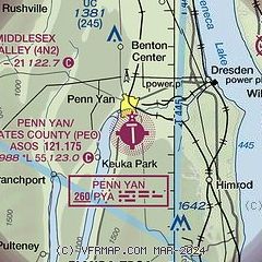
| Sectional chart |
|---|
|
CAUTION: Diagram may not be current

| Airport distance calculator |
|---|
|
|
| Sunrise and sunset |
|---|
|
Times for 11-Jun-2026
| | Local
(UTC-4) | | Zulu
(UTC) |
|---|
| Morning civil twilight | | 04:56 | | 08:56 |
| Sunrise | | 05:31 | | 09:31 |
| Sunset | | 20:45 | | 00:45 |
| Evening civil twilight | | 21:20 | | 01:20 |
|
| Current date and time |
|---|
| Zulu (UTC) | 11-Jun-2026 07:18:13 |
|---|
| Local (UTC-4) | 11-Jun-2026 03:18:13 |
|---|
|
| METAR |
|---|
| KPEO | 110653Z AUTO 21007KT 10SM FEW044 SCT085 21/19 A2978 RMK AO2 SLP076 T02110194
|
|
| TAF |
|---|
KITH
29nm E | 110540Z 1106/1206 VRB03KT P6SM BKN060 FM111400 26008KT P6SM BKN060 FM111700 28006G14KT P6SM -SHRA SCT040 BKN070 PROB30 1120/1123 5SM TSRA BR BKN025CB FM112300 VRB03KT P6SM BKN100
|
KELM
30nm S | 110540Z 1106/1206 VRB03KT 1SM BR BKN002 TEMPO 1106/1108 1/4SM FG VV002 FM110800 24005KT 1/4SM FG VV001 FM111200 26006G14KT P6SM SCT110 FM111900 27007G14KT P6SM -SHRA BKN090 PROB30 1119/1123 5SM TSRA BR BKN030CB FM120000 27002KT P6SM OVC050
|
|
| NOTAMs |
|---|
NOTAMs are issued by the DoD/FAA and will open in a separate window not controlled by AirNav.
|
|


