FAA INFORMATION EFFECTIVE 14 MAY 2026
Location
| FAA Identifier: | T51 |
| Lat/Long: | 30-02-33.9910N 095-40-02.0030W
30-02.566517N 095-40.033383W
30.0427753,-95.6672231
(estimated) |
| Elevation: | 166 ft. / 50.6 m (surveyed) |
| Variation: | 05E (2000) |
| From city: | 22 miles NW of HOUSTON, TX |
| Time zone: | UTC -5 (UTC -6 during Standard Time) |
| Zip code: | 77429 |
Airport Operations
| Airport use: | Open to the public |
| Activation date: | 05/1976 |
| Control tower: | no |
| ARTCC: | HOUSTON CENTER |
| FSS: | MONTGOMERY COUNTY FLIGHT SERVICE STATION |
| NOTAMs facility: | CXO (NOTAM-D service available) |
| Attendance: | DAWN-0000 |
| Wind indicator: | yes |
| Segmented circle: | no |
| Lights: | SS-SR, ACTVT LIRL RWY 17/35- CTAF. |
| Beacon: | white-green (lighted land airport)
FOR ROTG BCN CALL 936-521-9887. |
| Landing fee: | yes |
Airport Communications
| CTAF/UNICOM: | 122.8 |
| WX ASOS at DWH (6 nm E): | 128.375 (281-251-7853) |
| WX ASOS at IAH (17 nm E): | PHONE 713-338-9561 |
| WX AWOS-3 at TME (19 nm SW): | 119.525 (281-574-7296) |
Nearby radio navigation aids
| VOR radial/distance | | VOR name | | Freq | | Var |
|---|
| IAHr282/17.5 | | HUMBLE VORTAC | | 116.60 | | 05E |
| TNVr118/25.1 | | NAVASOTA VOR/DME | | 115.90 | | 08E |
Airport Services
| Fuel available: | 100LL |
| Parking: | tiedowns |
| Airframe service: | MAJOR |
| Powerplant service: | MAJOR |
Runway Information
Runway 17/35
| Dimensions: | 3440 x 50 ft. / 1049 x 15 m
RWY 17/35 2365 FT X 30 FT ASPH ON N END. |
| Surface: | asphalt/turf, in fair condition
NORTH END 2365 FT X 30 FT ASPH. |
| Runway edge lights: | low intensity
RWY 17/35 NSTD LIRL; NSTD COLORS, SINGLE THR LGT EACH RWY END. 2240 FT OF RWY USBL FOR NGT OPNS. RWY 17 THR RELCTD 300 FT FOR NGT OPNS; RWY 35 THR RELCTD 900 FT FOR NGT OPNS. |
| Runway edge markings: | SOUTH 1000 FT OF RWY TURF, NO MKGS. |
| RUNWAY 17 | | RUNWAY 35 |
| Latitude: | 30-02.849933N | | 30-02.282450N |
| Longitude: | 095-40.035933W | | 095-40.029900W |
| Elevation: | 161.0 ft. | | 166.0 ft. |
| Traffic pattern: | left | | left |
| Runway heading: | 174 magnetic, 179 true | | 354 magnetic, 359 true |
| Displaced threshold: | 255 ft.
THR DSPLCD 255 FT DAYS ONLY. | | 380 ft.
THR DSPLCD 400 FT DAYS ONLY. |
| Markings: | basic, in good condition | | basic, in good condition |
| Touchdown point: | yes, no lights | | yes, no lights |
| Obstructions: | 35 ft. trees, 201 ft. from runway, 125 ft. left and right of centerline
50 FT TREES, 0-199 DSTC, 125 FT L/R. | | 21 ft. pline, lighted, 10 ft. from runway
APCH RATIO 0:1 AT DAY DSPLCD THR; +4 FT FENCES 53 FT R. |
Airport Ownership and Management from official FAA records
| Ownership: | Privately-owned |
| Owner: | DANIEL JONES
16434 KITZMANN
CYPRESS, TX 77429
Phone 936-521-9887 |
| Manager: | DANIEL JONES
16434 KITZMAN
CYPRESS, TX 77429
Phone 936-521-9887
936-494-8909 ASST. MGR. |
Additional Remarks
| - | FOR CD CTC HOUSTON APCH AT 281-443-5844 TO CNL IFR CALL 281-443-5888. |
| - | RWY 17/35 4 FT FENCE 53 FT EAST OF CNTRLN. |
| - | DEER ON RWYS. |
| - | NORTH-SOUTH TRANSITIONAL ACFT WEST OF FIELD. |
| - | LEFT HAND TFC 500 FT & 1000 FT MSL. |
| - | CATTLE INVOF RWY. |
| - | ARPT CLSD MIDNIGHT TO DAWN. |
| - | PPR FOR ROTOR WING ACFT. |
Instrument Procedures
There are no published instrument procedures at T51.
Some nearby airports with instrument procedures:
KDWH - David Wayne Hooks Memorial Airport (6 nm E)
KIWS - West Houston Airport (13 nm S)
KIAH - George Bush Intercontinental/Houston Airport (17 nm E)
KTME - Houston Executive Airport (19 nm SW)
KCXO - Conroe/North Houston Regional Airport (23 nm NE)
|
|

Road maps at:
MapQuest
Bing
Google
| Aerial photo |
|---|
WARNING: Photo may not be current or correct
 Taken early December 2010
looking south.
Taken early December 2010
looking south.
Do you have a better or more recent aerial photo of Dan Jones International Airport that you would like to share? If so, please send us your photo.
|
| Sectional chart |
|---|
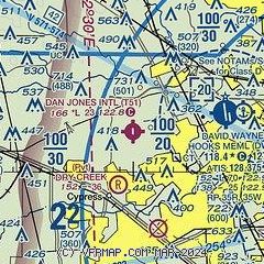
|
| Airport distance calculator |
|---|
|
|
| Sunrise and sunset |
|---|
|
Times for 18-May-2026
| | Local
(UTC-5) | | Zulu
(UTC) |
|---|
| Morning civil twilight | | 06:02 | | 11:02 |
| Sunrise | | 06:28 | | 11:28 |
| Sunset | | 20:10 | | 01:10 |
| Evening civil twilight | | 20:36 | | 01:36 |
|
| Current date and time |
|---|
| Zulu (UTC) | 18-May-2026 09:44:14 |
|---|
| Local (UTC-5) | 18-May-2026 04:44:14 |
|---|
|
| METAR |
|---|
KDWH
6nm E | 180853Z AUTO 15009G24KT 8SM SCT019 26/23 A2985 RMK AO2 SLP106 60000 T02610228 56020
|
KIAH
16nm E | 180853Z 16015KT 7SM BKN019 BKN190 OVC250 26/23 A2987 RMK AO2 PK WND 15028/0815 SLP114 60000 T02610233 56014
|
KTME
19nm SW | 180935Z AUTO 17017G22KT 7SM FEW017 26/24 A2985 RMK AO2
|
|
| TAF |
|---|
KIAH
16nm E | 180532Z 1806/1912 15013KT P6SM VCSH BKN018 OVC040 FM181400 14015G25KT P6SM BKN025 FM181600 15017G27KT P6SM BKN040 FM190300 14013KT P6SM BKN020
|
|
| NOTAMs |
|---|
NOTAMs are issued by the DoD/FAA and will open in a separate window not controlled by AirNav.
|
|

