FAA INFORMATION EFFECTIVE 19 MARCH 2026
Location
| FAA Identifier: | TS07 |
| Lat/Long: | 29-59-10.3800N 095-41-08.3850W
29-59.173000N 095-41.139750W
29.9862167,-95.6856625
(estimated) |
| Elevation: | 152.4 ft. / 46 m (estimated) |
| Variation: | 04E (2010) |
| From city: | 1 mile NE of CYPRESS, TX |
| Time zone: | UTC -5 (UTC -6 during Standard Time) |
| Zip code: | 77429 |
Airport Operations
| Airport use: | Private use. Permission required prior to landing |
| Activation date: | 03/1971 |
| Control tower: | no |
| ARTCC: | HOUSTON CENTER |
| FSS: | MONTGOMERY COUNTY FLIGHT SERVICE STATION |
| NOTAMs facility: | FDC (NOTAM-D service not available) |
| Attendance: | IREG |
| Wind indicator: | lighted |
| Segmented circle: | no |
| Lights: | RWY 18 & 36 PAPI; MIRL RWY 18/36 OPR DUSK TO 2300 LCL SUN-THU, DUSK TO 2359 LCL FRI-SAT. ALL OTR TIMES ACTVT - CTAF. |
| Beacon: | white-green (lighted land airport)
DUSK TO 2300 LCL SUN-THU, DUSK TO 2359 LCL FRI-SAT. ALL OTR TIMES ACTVT - CTAF. |
Airport Communications
| CTAF: | 122.9 |
| WX ASOS at DWH (8 nm NE): | 128.375 (281-251-7853) |
| WX AWOS-3 at TME (15 nm SW): | 119.525 (281-574-7296) |
| WX ASOS at IAH (18 nm E): | PHONE 713-338-9561 |
Nearby radio navigation aids
| VOR radial/distance | | VOR name | | Freq | | Var |
|---|
| IAHr271/17.8 | | HUMBLE VORTAC | | 116.60 | | 05E |
| TNVr125/26.5 | | NAVASOTA VOR/DME | | 115.90 | | 08E |
Airport Services
| Parking: | hangars and tiedowns |
| Airframe service: | MAJOR |
| Powerplant service: | MAJOR |
Runway Information
Runway 18/36
| Dimensions: | 3580 x 73 ft. / 1091 x 22 m |
| Surface: | turf, in good condition |
| Runway edge lights: | medium intensity |
| Runway edge markings: | MKD WITH EMBEDDED WHITE CONC MKRS AT RWY THR AND DSPLCD THR. |
| RUNWAY 18 | | RUNWAY 36 |
| Latitude: | 29-59.468333N | | 29-58.877667N |
| Longitude: | 095-41.147500W | | 095-41.132000W |
| Elevation: | 152.2 ft. | | 147.4 ft. |
| Traffic pattern: | left | | left |
| Runway heading: | 175 magnetic, 179 true | | 355 magnetic, 359 true |
| Displaced threshold: | 450 ft. | | 595 ft. |
| Markings: | NSTD, in good condition | | NSTD, in good condition |
| Visual slope indicator: | 2-light PAPI on left (5.05 degrees glide path) | | 2-light PAPI on right (4.00 degrees glide path) |
| Touchdown point: | yes, no lights | | yes, no lights |
| Obstructions: | 42 ft. pole, marked, 416 ft. from runway, 55 ft. left of centerline, 9:1 slope to clear | | 66 ft. tree, 617 ft. from runway, 115 ft. left of centerline, 9:1 slope to clear |
Airport Ownership and Management from official FAA records
| Ownership: | Privately-owned |
| Owner: | SKINNER ROAD ARPT COMMUNITY HOA
14425 DRY CREEK DR
CYPRESS, TX 77429
Phone (832) 349-8236 |
| Manager: | TOM BUSH
14403 DRY CREEK DR
CYPRESS, TX 77429
Phone (832) 349-8236
JEETER131@ME.COM |
Additional Remarks
| - | FOR CD CTC HOUSTON ARTCC AT 281-230-5622. |
Instrument Procedures
There are no published instrument procedures at TS07.
Some nearby airports with instrument procedures:
KDWH - David Wayne Hooks Memorial Airport (8 nm NE)
KIWS - West Houston Airport (10 nm S)
KTME - Houston Executive Airport (15 nm SW)
KIAH - George Bush Intercontinental/Houston Airport (18 nm E)
KSGR - Sugar Land Regional Airport (22 nm S)
|
|

Road maps at:
MapQuest
Bing
Google
| Aerial photo |
|---|
WARNING: Photo may not be current or correct

Do you have a better or more recent aerial photo of Dry Creek Airport that you would like to share? If so, please send us your photo.
|
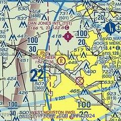
| Sectional chart |
|---|
|
| Airport distance calculator |
|---|
|
|
| Sunrise and sunset |
|---|
|
Times for 03-Apr-2026
| | Local
(UTC-5) | | Zulu
(UTC) |
|---|
| Morning civil twilight | | 06:47 | | 11:47 |
| Sunrise | | 07:11 | | 12:11 |
| Sunset | | 19:41 | | 00:41 |
| Evening civil twilight | | 20:06 | | 01:06 |
|
| Current date and time |
|---|
| Zulu (UTC) | 03-Apr-2026 14:31:40 |
|---|
| Local (UTC-5) | 03-Apr-2026 09:31:40 |
|---|
|
| METAR |
|---|
KDWH
9nm NE | 031353Z 15007KT 10SM BKN022 OVC046 24/21 A3000 RMK AO2 SLP155 T02390206
|
KTME
15nm SW | 031415Z AUTO 17009KT 5SM BR 24/22 A3001 RMK AO2
|
KIAH
17nm E | 031407Z 15010KT 10SM SCT015 BKN025 OVC035 24/21 A3000 RMK AO2 T02440211
|
|
| TAF |
|---|
KIAH
17nm E | 031135Z 0312/0418 15008KT P6SM SCT015 BKN025 FM031600 15013G23KT P6SM SCT020 BKN035 FM032000 15018G28KT P6SM BKN040 BKN150 FM040300 14016KT P6SM BKN015 FM041000 14007KT P6SM SCT007 BKN015 FM041500 15008KT P6SM SCT015 BKN025 PROB30 0415/0418 -SHRA
|
|
| NOTAMs |
|---|
NOTAMs are issued by the DoD/FAA and will open in a separate window not controlled by AirNav.
|
|

