FAA INFORMATION EFFECTIVE 09 JULY 2026
Location
| FAA Identifier: | 13C |
| Lat/Long: | 43-27-08.1000N 085-15-52.7000W
43-27.135000N 085-15.878333W
43.4522500,-85.2646389
(estimated) |
| Elevation: | 968.9 ft. / 295.3 m (surveyed) |
| Variation: | 05W (2000) |
| From city: | 1 mile NE of LAKEVIEW, MI |
| Time zone: | UTC -4 (UTC -5 during Standard Time) |
| Zip code: | 48850 |
Airport Operations
| Airport use: | Open to the public |
| Activation date: | 12/1944 |
| Control tower: | no |
| ARTCC: | CHICAGO CENTER |
| FSS: | LANSING FLIGHT SERVICE STATION |
| NOTAMs facility: | LAN (NOTAM-D service available) |
| Attendance: | 0800-DUSK
FOR SVC AFT HRS CALL AMGR. |
| Wind indicator: | lighted |
| Segmented circle: | yes |
| Lights: | ACTVT REIL RWY 10 & 28; PAPI RWY 10 & 28; MIRL RWY 10/28 - CTAF. |
| Beacon: | white-green (lighted land airport)
Operates sunset to sunrise. |
Airport Communications
| CTAF/UNICOM: | 122.8 |
| GREAT LAKES APPROACH: | 124.6 [0530-0000] |
| GREAT LAKES DEPARTURE: | 124.6 [0530-0000] |
| WX AWOS-3P at RQB (19 nm NW): | 125.875 (231-796-0884) |
- APCH/DEP SVC PRVDD BY CHICAGO ARTCC (ZAU) ON FREQS 132.275/254.35 (MUSKEGON RCAG) WHEN GREAT LAKES APCH CTL CLSD.
Airport Services
| Fuel available: | 100LL |
| Parking: | tiedowns |
| Airframe service: | MAJOR |
| Powerplant service: | MAJOR |
| Bottled oxygen: | NONE |
| Bulk oxygen: | NONE |
Runway Information
Runway 10/28
| Dimensions: | 3499 x 75 ft. / 1066 x 23 m |
| Surface: | asphalt, in good condition |
| Weight bearing capacity: | |
| Runway edge lights: | medium intensity |
| RUNWAY 10 | | RUNWAY 28 |
| Latitude: | 43-27.128585N | | 43-27.140355N |
| Longitude: | 085-16.272793W | | 085-15.482405W |
| Elevation: | 963.0 ft. | | 967.0 ft. |
| Traffic pattern: | left | | left |
| Runway heading: | 094 magnetic, 089 true | | 274 magnetic, 269 true |
| Markings: | nonprecision, in good condition | | nonprecision, in good condition |
| Visual slope indicator: | 2-light PAPI on left (3.00 degrees glide path) | | 2-light PAPI on left (3.00 degrees glide path) |
| Runway end identifier lights: | yes | | yes |
| Touchdown point: | yes, no lights | | yes, no lights |
| Obstructions: | 50 ft. tree, 956 ft. from runway, 380 ft. left of centerline, 15:1 slope to clear | | none |
Airport Ownership and Management from official FAA records
| Ownership: | Publicly-owned |
| Owner: | VILLAGE OF LAKEVIEW
208 S LINCOLN AVE, PO BOX 30
LAKEVIEW, MI 48850-0030
Phone 989-352-6322 |
| Manager: | DARIN DOOD
208 S LINCOLN AVE, PO BOX 30
LAKEVIEW, MI 48850-0030
Phone 989-289-3110
CELL. |
Additional Remarks
| - | EXTSV AGRICULTURAL OPS. |
| - | DEER & LRG BIRDS ON & INVOF ARPT. |
| - | FOR CD CTC GREAT LAKES APCH AT 269-459-3344, WHEN APCH CLSD CTC CHICAGO ARTCC AT 630-906-8921. |
Instrument Procedures
NOTE: All procedures below are presented as PDF files. If you need a reader for these files, you should download the free Adobe Reader.NOT FOR NAVIGATION. Please procure official charts for flight.
FAA instrument procedures published for use from 09 July 2026 at 0901Z to 06 August 2026 at 0900Z.
IAPs - Instrument Approach Procedures |
|---|
| RNAV (GPS) RWY 10 | |
download (173KB) |
| RNAV (GPS) RWY 28 | |
download (180KB) |
| NOTE: Special Take-Off Minimums/Departure Procedures apply | |
download (352KB) |
Other nearby airports with instrument procedures:
6D6 - Greenville Municipal Airport (19 nm S)
KRQB - Roben-Hood Airport (19 nm NW)
KMOP - Mount Pleasant Municipal Airport (25 nm NE)
KAMN - Gratiot Community Airport (26 nm E)
8D4 - Paul C Miller/Sparta Airport (27 nm SW)
|
|

Road maps at:
MapQuest
Bing
Google
| Aerial photo |
|---|
WARNING: Photo may not be current or correct
 Photo by Paul "Wally" Roode
Do you have a better or more recent aerial photo of Lakeview Airport/Griffith Field that you would like to share? If so, please send us your photo.
|
| Sectional chart |
|---|
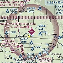
|
| Airport distance calculator |
|---|
|
|
| Sunrise and sunset |
|---|
|
Times for 01-Aug-2026
| | Local
(UTC-4) | | Zulu
(UTC) |
|---|
| Morning civil twilight | | 05:59 | | 09:59 |
| Sunrise | | 06:32 | | 10:32 |
| Sunset | | 21:03 | | 01:03 |
| Evening civil twilight | | 21:36 | | 01:36 |
|
| Current date and time |
|---|
| Zulu (UTC) | 01-Aug-2026 18:59:22 |
|---|
| Local (UTC-4) | 01-Aug-2026 14:59:22 |
|---|
|
| METAR |
|---|
KRQB
19nm NW | 011835Z AUTO 08006KT 10SM OVC085 22/18 A2987 RMK AO2
|
KMOP
25nm NE | 011835Z AUTO 03003KT 10SM BKN070 OVC095 21/20 A2987 RMK AO2 T02110202
|
KAMN
27nm E | 011835Z AUTO 03008KT 10SM -RA SCT043 BKN055 OVC065 21/20 A2986 RMK AO2
|
KFFX
32nm W | 011835Z AUTO 07008KT 10SM BKN012 BKN019 OVC100 22/19 A2985 RMK AO2
|
KY70
32nm S | 011835Z AUTO 05010KT 10SM -RA BKN009 BKN036 OVC046 21/19 A2985 RMK AO2
|
KGRR
36nm S | 011853Z 06011KT 5SM -RA BR FEW010 SCT050 OVC095 21/19 A2984 RMK AO2 RAB1757 SLP101 P0001 T02110194 $
|
|
| TAF |
|---|
KGRR
36nm S | 011738Z 0118/0218 07012KT 6SM -SHRA BR BKN015 FM011900 06012KT 5SM -SHRA BR BKN025 PROB30 0119/0124 2SM +SHRA BR BKN015 FM020000 05009KT 4SM -SHRA BR OVC025 FM020600 04008KT 4SM -SHRA BR OVC008 FM021400 04010KT P6SM BKN015
|
|
| NOTAMs |
|---|
NOTAMs are issued by the DoD/FAA and will open in a separate window not controlled by AirNav.
|
|

