FAA INFORMATION EFFECTIVE 19 FEBRUARY 2026
Location
| FAA Identifier: | 59B |
| Lat/Long: | 45-37-56.7990N 070-14-50.9810W
45-37.946650N 070-14.849683W
45.6324442,-70.2474947
(estimated) |
| Elevation: | 1177.9 ft. / 359.0 m (surveyed) |
| Variation: | 16W (2020) |
| From city: | 1 mile W of JACKMAN, ME |
| Time zone: | UTC -5 (UTC -4 during Daylight Saving Time) |
| Zip code: | 04945 |
Airport Operations
| Airport use: | Open to the public |
| Activation date: | 04/1940 |
| Control tower: | no |
| ARTCC: | BOSTON CENTER |
| FSS: | BANGOR FLIGHT SERVICE STATION |
| NOTAMs facility: | BGR (NOTAM-D service available) |
| Attendance: | UNATNDD |
| Wind indicator: | lighted |
| Segmented circle: | yes |
| Lights: | ACTVT REIL RWY 31; MIRL RWY 13/31 - CTAF. |
| Beacon: | white-green (lighted land airport)
Operates sunset to sunrise. |
| International operations: | customs landing rights airport |
Airport Communications
| CTAF: | 122.9 |
| WX AWOS-AV: | 122.9 |
- APCH/DEP SVC PRVDD BY BOSTON ARTCC ON FREQS 120.25/346.4 (BANGOR RCAG).
Airport Services
| Fuel available: | 100LL
100LL:FUEL AVBL 24 HRS WITH MAJOR CREDIT CARD. |
| Oil available: | MNTN 122.9 WI VCNTY OF ARPT. 3 CLICKS ADZY & WX. |
| Parking: | hangars and tiedowns |
| Airframe service: | NONE |
| Powerplant service: | NONE |
| Bottled oxygen: | NONE |
| Bulk oxygen: | NONE |
Runway Information
Runway 13/31
| Dimensions: | 3601 x 75 ft. / 1098 x 23 m |
| Surface: | asphalt, in good condition |
| Runway edge lights: | medium intensity |
| RUNWAY 13 | | RUNWAY 31 |
| Latitude: | 45-38.048077N | | 45-37.845187N |
| Longitude: | 070-15.246397W | | 070-14.452992W |
| Elevation: | 1177.9 ft. | | 1171.0 ft. |
| Traffic pattern: | left | | left |
| Runway heading: | 126 magnetic, 110 true | | 306 magnetic, 290 true |
| Markings: | nonprecision, in good condition | | nonprecision, in good condition |
| Runway end identifier lights: | | | yes |
| Touchdown point: | yes, no lights | | yes, no lights |
| Obstructions: | 12 ft. tree, 221 ft. from runway, 179 ft. right of centerline, 1:1 slope to clear
+4 FT GRASS 50-200 FT FM THR, 80 FT R OF CNTRLN. | | 11 ft. tree, 208 ft. from runway, 115 ft. left of centerline, 1:1 slope to clear
+12 FT TREE AND BRUSH 0-20 FT FM THR, 120 FT R OF CNTRLN; +4 FT TREE 10 FT FM THR, 150 FT L OF CNTRLN. |
Helipad H1
| Dimensions: | 125 x 80 ft. / 38 x 24 m |
| Surface: | turf |
| Latitude: | 45-37.965232N | | |
| Longitude: | 070-14.927538W | | |
| Elevation: | 1178.0 ft. | | |
| Traffic pattern: | left | | left |
Airport Ownership and Management from official FAA records
| Ownership: | Publicly-owned |
| Owner: | TOWN OF JACKMAN
TOWN OFFICE, 569 MAIN ST
JACKMAN, ME 04945
Phone 207-668-2111 |
| Manager: | KIRSTIE HALE
TOWN OFFICE, 569 MAIN ST
JACKMAN, ME 04945
Phone 207-668-2111 |
Additional Remarks
| - | GEESE, DEER & MOOSE ON & INVOF ARPT. |
| - | ARPT PHONE AVBL FOR LOCAL CALLS ONLY. |
| - | FOR CD CTC BOSTON ARTCC AT 603-879-6859. |
| - | COLD TEMPERATURE AIRPORT. ALTITUDE CORRECTION REQUIRED AT OR BELOW -23C. |
Instrument Procedures
NOTE: All procedures below are presented as PDF files. If you need a reader for these files, you should download the free Adobe Reader.NOT FOR NAVIGATION. Please procure official charts for flight.
FAA instrument procedures published for use from 19 February 2026 at 0901Z to 19 March 2026 at 0900Z.
IAPs - Instrument Approach Procedures |
|---|
| RNAV (GPS) RWY 13 **CHANGED** | |
download (204KB) |
| RNAV (GPS) RWY 31 **CHANGED** | |
download (188KB) |
| NOTE: Special Alternate Minimums apply | |
download (150KB) |
| NOTE: Special Take-Off Minimums/Departure Procedures apply | |
download (549KB) |
Other nearby airports with instrument procedures:
52B - Moosehead Aero Marine Seaplane Base (29 nm E)
3B1 - Greenville Municipal Airport (31 nm E)
B21 - Sugarloaf Regional Airport (33 nm S)
8B0 - Stephen A Bean Municipal Airport (42 nm SW)
M57 - Rangeley Lake Seaplane Base (44 nm SW)
|
|

Road maps at:
MapQuest
Bing
Google
| Aerial photo |
|---|
WARNING: Photo may not be current or correct

Do you have a better or more recent aerial photo of Newton Field Airport that you would like to share? If so, please send us your photo.
|
| Sectional chart |
|---|
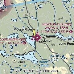
|
| Airport distance calculator |
|---|
|
|
| Sunrise and sunset |
|---|
|
Times for 04-Mar-2026
| | Local
(UTC-5) | | Zulu
(UTC) |
|---|
| Morning civil twilight | | 05:45 | | 10:45 |
| Sunrise | | 06:15 | | 11:15 |
| Sunset | | 17:30 | | 22:30 |
| Evening civil twilight | | 18:00 | | 23:00 |
|
| Current date and time |
|---|
| Zulu (UTC) | 05-Mar-2026 02:49:02 |
|---|
| Local (UTC-5) | 04-Mar-2026 21:49:02 |
|---|
|
| METAR |
|---|
KGNR
31nm E | 050156Z AUTO 00000KT 02/M05 A3009 RMK AO1 SLP206 T00221050
|
CWHV
40nm NW | 050200Z AUTO 25002KT 03/M03 RMK AO1 SLP207 T00291030 53011
|
K8B0
44nm SW | 050235Z AUTO 21004KT 10SM FEW029 SCT036 SCT042 00/M04 A3015 RMK AO2
|
|
| NOTAMs |
|---|
NOTAMs are issued by the DoD/FAA and will open in a separate window not controlled by AirNav.
|
|

