FAA INFORMATION EFFECTIVE 22 JANUARY 2026
Location
| FAA Identifier: | I67 |
| Lat/Long: | 39-15-33.3670N 084-46-27.5000W
39-15.556117N 084-46.458333W
39.2592686,-84.7743056
(estimated) |
| Elevation: | 584.1 ft. / 178.0 m (surveyed) |
| Variation: | 05W (2010) |
| From city: | 2 miles E of HARRISON, OH |
| Time zone: | UTC -5 (UTC -4 during Daylight Saving Time) |
| Zip code: | 45030 |
Airport Operations
| Airport use: | Open to the public |
| Activation date: | 09/1945 |
| Control tower: | no |
| ARTCC: | INDIANAPOLIS CENTER |
| FSS: | DAYTON FLIGHT SERVICE STATION |
| NOTAMs facility: | I67 (NOTAM-D service available) |
| Attendance: | MON-SAT 0830-1800, ALL SUN 0900-1700
UNATNDD ALL MAJOR HOLS. |
| Wind indicator: | lighted |
| Segmented circle: | no |
| Lights: | ACTVT OR INCR INTST MIRL RWY 01/19 - CTAF. MIRL RWY 01/19 PRESET LOW INTST SS-SR. PAPI RWY 01 & 19 OPR CONSLY. |
| Beacon: | white-green (lighted land airport)
Operates sunset to sunrise. |
Airport Communications
| CTAF/UNICOM: | 123.0 |
| WX AWOS-3PT: | 118.15 (513-569-4964) |
| CINCINNATI APPROACH: | 128.7 |
| CINCINNATI DEPARTURE: | 128.7 |
| WX ASOS at HAO (13 nm NE): | 121.425 (513-863-6137) |
| WX ASOS at CVG (14 nm S): | 134.375 (859-414-0353) |
| WX AWOS-3PT at OXD (15 nm N): | 118.625 (513-273-2032) |
| WX ASOS at LUK (19 nm SE): | PHONE 513-321-6291 |
Nearby radio navigation aids
| NDB name | | Hdg/Dist | | Freq | | Var | | ID |
|---|
| SPORTYS | | 297/28.2 | | 245 | | 04W | | PWF | .--. .-- ..-. |
Airport Services
| Fuel available: | 100LL
100LL:FUEL AVBL H24 SELF SVC. |
| Parking: | hangars and tiedowns |
| Airframe service: | MAJOR |
| Powerplant service: | MAJOR |
| Bottled oxygen: | NONE |
| Bulk oxygen: | NONE |
Runway Information
Runway 1/19
| Dimensions: | 2808 x 60 ft. / 856 x 18 m |
| Surface: | asphalt, in good condition |
| Runway edge lights: | medium intensity |
| RUNWAY 1 | | RUNWAY 19 |
| Latitude: | 39-15.324840N | | 39-15.787383N |
| Longitude: | 084-46.459848W | | 084-46.456810W |
| Elevation: | 581.4 ft. | | 580.6 ft. |
| Traffic pattern: | left | | left |
| Runway heading: | 005 magnetic, 000 true | | 185 magnetic, 180 true |
| Displaced threshold: | 75 ft. | | 219 ft. |
| Markings: | nonprecision, in good condition | | nonprecision, in good condition |
| Visual slope indicator: | 2-light PAPI on left (3.00 degrees glide path)
PAPI UNUSBL BYD 7 DEGS RIGHT OF CNTRLN. | | 2-light PAPI on left (3.50 degrees glide path)
PAPI UNUSBL BYD 9 DEGS LEFT OR RIGHT OF CNTRLN. |
| Runway end identifier lights: | no | | no |
| Touchdown point: | yes, no lights | | yes, no lights |
| Obstructions: | 16 ft. road, 257 ft. from runway, 3:1 slope to clear
APCH SLP 18:1 TO DTHR OVR +22 FT TREE, 329 DIST, 27 FT L. | | 57 ft. tree, 442 ft. from runway, 49 ft. left of centerline, 4:1 slope to clear
+23 FT BLDG, 140 FT DIST, 240 FT R. |
Airport Ownership and Management from official FAA records
| Ownership: | Publicly-owned |
| Owner: | CINCINNATI STATE TECH & CMTY COLL
3520 CENTRAL PKWY
CINCINNATI, OH 45223-2612
Phone 513-569-4956 |
| Manager: | WILL BERNINGER
10004 WEST RD
HARRISON, OH 45030-1955
Phone 513-367-1201
OR 513-367-5070. |
Additional Remarks
| - | FOR CD CTC CINCINNATI APCH AT 859-372-6440. |
Instrument Procedures
NOTE: All procedures below are presented as PDF files. If you need a reader for these files, you should download the free Adobe Reader.NOT FOR NAVIGATION. Please procure official charts for flight.
FAA instrument procedures published for use from 22 January 2026 at 0901Z to 19 February 2026 at 0900z.
IAPs - Instrument Approach Procedures |
|---|
| RNAV (GPS) RWY 19 | |
download (209KB) |
| NOTE: Special Take-Off Minimums/Departure Procedures apply | |
download (424KB) |
Other nearby airports with instrument procedures:
KHAO - Butler County Regional Airport/Hogan Field (13 nm NE)
KCVG - Cincinnati/Northern Kentucky International Airport (14 nm S)
KOXD - Miami University Airport (15 nm N)
KLUK - Cincinnati Municipal Airport/Lunken Field (19 nm SE)
KMWO - Middletown Regional Airport/Hook Field (24 nm NE)
|
|

Road maps at:
MapQuest
Bing
Google
| Aerial photo |
|---|
WARNING: Photo may not be current or correct
 Photo courtesy of Harrison Social Flites Flying Club
Photo taken 08-Feb-2013
looking north.
Photo courtesy of Harrison Social Flites Flying Club
Photo taken 08-Feb-2013
looking north.
Do you have a better or more recent aerial photo of Cincinnati West Airport that you would like to share? If so, please send us your photo.
|
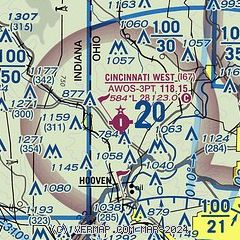
| Sectional chart |
|---|
|
| Airport distance calculator |
|---|
|
|
| Sunrise and sunset |
|---|
|
Times for 18-Feb-2026
| | Local
(UTC-5) | | Zulu
(UTC) |
|---|
| Morning civil twilight | | 07:01 | | 12:01 |
| Sunrise | | 07:28 | | 12:28 |
| Sunset | | 18:18 | | 23:18 |
| Evening civil twilight | | 18:45 | | 23:45 |
|
| Current date and time |
|---|
| Zulu (UTC) | 19-Feb-2026 02:18:18 |
|---|
| Local (UTC-5) | 18-Feb-2026 21:18:18 |
|---|
|
| METAR |
|---|
| KI67 | 190155Z AUTO 18007KT 10SM CLR 14/12 A2974 RMK AO1
|
KCVG
14nm S | 190152Z 19009KT 10SM CLR 13/11 A2975 RMK AO2 SLP071 T01280111 $
|
KHAO
14nm NE | 190153Z AUTO 19004KT 10SM CLR 16/12 A2974 RMK AO2 SLP071 T01560117
|
KOXD
15nm N | 181640Z AUTO 23011KT 10SM SCT020 BKN025 OVC046 16/12 A2970 RMK AO2
|
KLUK
19nm SE | 190153Z 18004KT 10SM CLR 13/11 A2976 RMK AO2 SLP075 T01330111
|
|
| TAF |
|---|
KCVG
14nm S | 181741Z 1818/1924 22012G22KT P6SM BKN027 FM182000 22007KT P6SM SCT025 BKN250 FM190600 19003KT 5SM BR SCT015 TEMPO 1907/1911 2SM BR FM191300 15005KT P6SM SCT015 FM191700 16007KT P6SM BKN035 PROB30 1920/1922 4SM -SHRA BKN025 FM192200 17007KT 5SM -SHRA BR BKN070 PROB30 1922/1924 4SM -TSRA OVC025CB
|
KLUK
19nm SE | 181741Z 1818/1918 22012G22KT P6SM BKN025 FM182000 20008KT P6SM SCT025 BKN035 FM190600 19003KT 2SM BR SCT015 TEMPO 1908/1912 1/2SM FG FM191300 15005KT P6SM SCT015 FM191700 16007KT P6SM BKN035
|
|
| NOTAMs |
|---|
NOTAMs are issued by the DoD/FAA and will open in a separate window not controlled by AirNav.
|
|


