FAA INFORMATION EFFECTIVE 12 JUNE 2025
Location
| FAA Identifier: | ISW |
| Lat/Long: | 44-21-37.2780N 089-50-20.5420W
44-21.621300N 089-50.342367W
44.3603550,-89.8390394
(estimated) |
| Elevation: | 1021 ft. / 311.2 m (surveyed) |
| Variation: | 01W (1995) |
| From city: | 1 mile S of WISCONSIN RAPIDS, WI |
| Time zone: | UTC -5 (UTC -6 during Standard Time) |
| Zip code: | 54494 |
Airport Operations
| Airport use: | Open to the public |
| Activation date: | 11/1959 |
| Control tower: | no |
| ARTCC: | MINNEAPOLIS CENTER |
| FSS: | GREEN BAY FLIGHT SERVICE STATION |
| NOTAMs facility: | ISW (NOTAM-D service available) |
| Attendance: | 0700-1700 |
| Wind indicator: | lighted |
| Segmented circle: | yes |
| Lights: | MIRL RWY 02/20 PRESET TO LOW SS-SR, TO INCR INTST AND ACTVT REIL RWY 02 & 20; PAPI RWY 02, 20 & 30; MIRL RWY 12/30 - CTAF. |
| Beacon: | white-green (lighted land airport)
Operates sunset to sunrise. |
Airport Communications
| CTAF/UNICOM: | 122.8 |
| WX ASOS: | 126.575 (715-421-2120) |
| WX AWOS-3 at STE (17 nm NE): | 119.275 (715-344-5960) |
- APCH/DEP SVC PRVDD BY MINNEAPOLIS ARTCC ON FREQS 124.4/317.7(MOSINEE RCAG)
Airport Services
| Fuel available: | 100LL JET-A JET-A+
100LL:24 HR SELF SVC FUEL AVBL WITH CREDIT CARD. |
| Parking: | hangars and tiedowns |
| Airframe service: | NONE |
| Powerplant service: | NONE |
| Bottled oxygen: | NONE |
| Bulk oxygen: | NONE |
Runway Information
Runway 2/20
| Dimensions: | 5500 x 100 ft. / 1676 x 30 m |
| Surface: | asphalt, in excellent condition |
| Weight bearing capacity: | | Single wheel: | 40.0 | | Double wheel: | 60.0 |
|
| Runway edge lights: | medium intensity |
| RUNWAY 2 | | RUNWAY 20 |
| Latitude: | 44-21.201172N | | 44-22.052797N |
| Longitude: | 089-50.510577W | | 089-50.083530W |
| Elevation: | 1010.8 ft. | | 1021.0 ft. |
| Traffic pattern: | left | | left |
| Runway heading: | 021 magnetic, 020 true | | 201 magnetic, 200 true |
| Markings: | nonprecision, in good condition | | nonprecision, in good condition |
| Visual slope indicator: | 4-light PAPI on left (3.00 degrees glide path) | | 4-light PAPI on left (3.50 degrees glide path) |
| Runway end identifier lights: | yes | | yes |
| Touchdown point: | yes, no lights | | yes, no lights |
| Instrument approach: | SDF | | |
| Obstructions: | 15 ft. trees, 250 ft. from runway, 215 ft. right of centerline, 3:1 slope to clear | | 68 ft. tree, 1560 ft. from runway, 330 ft. left of centerline, 20:1 slope to clear |
Runway 12/30
| Dimensions: | 3470 x 60 ft. / 1058 x 18 m |
| Surface: | asphalt, in excellent condition |
| Weight bearing capacity: | | Single wheel: | 12.0 | | Double wheel: | 20.0 |
|
| Runway edge lights: | medium intensity |
| RUNWAY 12 | | RUNWAY 30 |
| Latitude: | 44-21.787423N | | 44-21.537833N |
| Longitude: | 089-50.651033W | | 089-49.935167W |
| Elevation: | 1020.0 ft. | | 1011.6 ft. |
| Traffic pattern: | left | | left |
| Runway heading: | 117 magnetic, 116 true | | 297 magnetic, 296 true |
| Markings: | nonprecision, in good condition | | nonprecision, in good condition |
| Visual slope indicator: | | | 4-light PAPI on left (4.00 degrees glide path) |
| Runway end identifier lights: | no | | no |
| Touchdown point: | yes, no lights | | yes, no lights |
Runway 18/36
| Dimensions: | 2072 x 50 ft. / 632 x 15 m |
| Surface: | turf, in fair condition |
| Runway edge markings: | MKD WITH YELLOW METAL TRIANGLES. |
| RUNWAY 18 | | RUNWAY 36 |
| Latitude: | 44-21.707000N | | 44-21.367000N |
| Longitude: | 089-50.563667W | | 089-50.526500W |
| Elevation: | 1016.0 ft. | | 1014.9 ft. |
| Traffic pattern: | left | | left |
| Runway heading: | 177 magnetic, 176 true | | 357 magnetic, 356 true |
| Touchdown point: | yes, no lights | | yes, no lights |
Airport Ownership and Management from official FAA records
| Ownership: | Publicly-owned |
| Owner: | WISCONSIN RAPIDS
3620 1ST STREET SOUTH
WISCONSIN RAPIDS, WI 54495
Phone (715) 423-0330
ALSO VILLAGE OF PORT EDWARDS; TOWN OF GRAND RAPIDS, CITY OF NEKOOSA. |
| Manager: | JEREMY SICKLER
3620 1ST ST SOUTH
WISCONSIN RAPIDS, WI 54494
Phone (715) 423-0330
AFT HRS SVC CALL 715-741-2114 |
Additional Remarks
| - | BIRDS ON & INVOF ARPT. |
| - | ULTRALIGHT ACFT OPRG ON & INVOF ARPT. |
| - | FOR CD IF UNA TO CTC ON FSS FREQ, CTC MINNEAPOLIS ARTCC AT 651-463-5588. |
Instrument Procedures
NOTE: All procedures below are presented as PDF files. If you need a reader for these files, you should download the free Adobe Reader.NOT FOR NAVIGATION. Please procure official charts for flight.
FAA instrument procedures published for use from 12 June 2025 at 0901Z to 10 July 2025 at 0900z.
IAPs - Instrument Approach Procedures |
|---|
| RNAV (GPS) RWY 02 **CHANGED** | |
download (309KB) |
| RNAV (GPS) RWY 20 **CHANGED** | |
download (246KB) |
| NOTE: Special Alternate Minimums apply | |
download (140KB) |
| NOTE: Special Take-Off Minimums/Departure Procedures apply | |
download (484KB) |
Other nearby airports with instrument procedures:
KSTE - Stevens Point Municipal Airport (17 nm NE)
KDAF - Necedah Airport (22 nm SW)
KMFI - Marshfield Municipal Airport (22 nm NW)
63C - Adams County Airport-Legion Field (24 nm S)
KCWA - Central Wisconsin Airport (26 nm N)
|
|

Road maps at:
MapQuest
Bing
Google
| Aerial photo |
|---|
WARNING: Photo may not be current or correct
 Photo by Mark Consigny
Photo taken 05-Oct-2011
looking south.
Photo by Mark Consigny
Photo taken 05-Oct-2011
looking south.
Do you have a better or more recent aerial photo of Alexander Field South Wood County Airport that you would like to share? If so, please send us your photo.
|
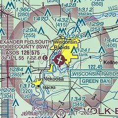
| Sectional chart |
|---|
|
| Airport distance calculator |
|---|
|
|
| Sunrise and sunset |
|---|
|
Times for 07-Jul-2025
| | Local
(UTC-5) | | Zulu
(UTC) |
|---|
| Morning civil twilight | | 04:48 | | 09:48 |
| Sunrise | | 05:24 | | 10:24 |
| Sunset | | 20:45 | | 01:45 |
| Evening civil twilight | | 21:21 | | 02:21 |
|
| Current date and time |
|---|
| Zulu (UTC) | 07-Jul-2025 17:20:22 |
|---|
| Local (UTC-5) | 07-Jul-2025 12:20:22 |
|---|
|
| METAR |
|---|
| KISW | 071654Z AUTO 06004KT 10SM OVC034 22/13 A3010 RMK AO2 SLP188 T02220133
|
KSTE
17nm NE | 071655Z AUTO 10004KT 10SM SCT028 SCT039 SCT060 24/16 A3010 RMK AO2 T02380159
|
|
| TAF |
|---|
KCWA
25nm N | 071420Z 0714/0812 VRB03KT P6SM BKN040 FM072100 17003KT P6SM SCT250 FM080600 15004KT P6SM BKN150 FM080900 15004KT P6SM BKN070 TEMPO 0809/0812 3SM -SHRA BKN045
|
|
| NOTAMs |
|---|
NOTAMs are issued by the DoD/FAA and will open in a separate window not controlled by AirNav.
|
|


