FAA INFORMATION EFFECTIVE 09 JULY 2026
Location
| FAA Identifier: | VLA |
| Lat/Long: | 38-59-29.2770N 089-09-58.2820W
38-59.487950N 089-09.971367W
38.9914658,-89.1661894
(estimated) |
| Elevation: | 537.2 ft. / 163.7 m (surveyed) |
| Variation: | 01W (2005) |
| From city: | 3 miles NW of VANDALIA, IL |
| Time zone: | UTC -5 (UTC -6 during Standard Time) |
| Zip code: | 62471 |
Airport Operations
| Airport use: | Open to the public |
| Activation date: | 07/1944 |
| Control tower: | no |
| ARTCC: | KANSAS CITY CENTER |
| FSS: | SAINT LOUIS FLIGHT SERVICE STATION |
| NOTAMs facility: | STL (NOTAM-D service available) |
| Attendance: | ALL/IRREGULAR/ |
| Wind indicator: | lighted |
| Segmented circle: | yes |
| Lights: | ACTVT REIL RWY 18, 27 & 36; PAPI RWY 18; MIRL RWY 09/27 - CTAF. MIRL RWY 18/36 PRESET TO LOW INTST, TO INCR INTST - CTAF. |
| Beacon: | white-green (lighted land airport)
Operates sunset to sunrise. |
Airport Communications
| CTAF/UNICOM: | 122.8 |
| WX AWOS-AV: | 122.8 (618-283-9595) |
| WX AWOS-2 at GRE (14 nm SW): | 120.0 (618-664-1939) |
- APCH/DEP SVC PRVDD BY KANSAS CITY ARTCC ON FREQS 124.3/269.15 (DECATUR RCAG)
Nearby radio navigation aids
| VOR radial/distance | | VOR name | | Freq | | Var |
|---|
| BIBr275/32.2 | | BIBLE GROVE VORTAC | | 109.00 | | 03E |
| ENLr355/34.3 | | CENTRALIA VORTAC | | 115.00 | | 04E |
| TOYr063/38.3 | | TROY VORTAC | | 116.00 | | 04E |
| NDB name | | Hdg/Dist | | Freq | | Var | | ID |
|---|
| SHELBYVILLE | | 213/29.1 | | 365 | | 02W | | SYZ | ... -.-- --.. |
Airport Services
| Fuel available: | 100LL JET-A
100LL:FUEL IS SELF-SERVE WITH CREDIT CARD. |
| Parking: | hangars and tiedowns |
| Airframe service: | MAJOR |
| Powerplant service: | MAJOR |
| Bottled oxygen: | NONE |
| Bulk oxygen: | NONE |
Runway Information
Runway 18/36
| Dimensions: | 3751 x 100 ft. / 1143 x 30 m |
| Surface: | asphalt/porous friction courses, in good condition |
| Weight bearing capacity: | |
| Runway edge lights: | medium intensity |
| RUNWAY 18 | | RUNWAY 36 |
| Latitude: | 38-59.855173N | | 38-59.237187N |
| Longitude: | 089-10.037287W | | 089-10.032815W |
| Elevation: | 530.1 ft. | | 533.0 ft. |
| Traffic pattern: | left | | left |
| Runway heading: | 181 magnetic, 180 true | | 001 magnetic, 360 true |
| Markings: | nonprecision, in good condition | | nonprecision, in good condition |
| Visual slope indicator: | 4-light PAPI on left (3.00 degrees glide path) | | |
| Runway end identifier lights: | yes | | yes |
| Touchdown point: | yes, no lights | | yes, no lights |
| Obstructions: | 18 ft. road, 575 ft. from runway, 284 ft. left of centerline, 20:1 slope to clear | | 14 ft. road, 522 ft. from runway, 278 ft. right of centerline, 23:1 slope to clear
APCH SLOPE 23:1 TO RELOCATED THR USING PART 77 SFC. |
Runway 9/27
| Dimensions: | 3001 x 75 ft. / 915 x 23 m |
| Surface: | asphalt, in fair condition |
| Weight bearing capacity: | |
| Runway edge lights: | medium intensity |
| RUNWAY 9 | | RUNWAY 27 |
| Latitude: | 38-59.413748N | | 38-59.416520N |
| Longitude: | 089-10.208473W | | 089-09.575018W |
| Elevation: | 531.6 ft. | | 537.1 ft. |
| Traffic pattern: | left | | left |
| Runway heading: | 091 magnetic, 090 true | | 271 magnetic, 270 true |
| Markings: | basic, in good condition | | basic, in good condition |
| Runway end identifier lights: | | | yes |
| Touchdown point: | yes, no lights | | yes, no lights |
Airport Ownership and Management from official FAA records
| Ownership: | Publicly-owned |
| Owner: | VANDALIA PARK DISTRICT
900 NORTH LOCUST
VANDALIA, IL 62471
Phone 618-283-4973 |
| Manager: | CHAD FELDPOUCH
1754 N. 400 ST
VANDALIA, IL 62471
Phone 618-267-8035 |
Additional Remarks
| A30A-27 | 8 FT CROPS 200 FT FM RWY END PENETRATING PART 77 SFC. |
| - | FOR WX ADVY, 3 CLICKS CTAF. PHONE (618)283-9595. |
| - | FOR CD CTC KANSAS CITY ARTCC AT 913-254-8508. |
Instrument Procedures
NOTE: All procedures below are presented as PDF files. If you need a reader for these files, you should download the free Adobe Reader.NOT FOR NAVIGATION. Please procure official charts for flight.
FAA instrument procedures published for use from 09 July 2026 at 0901Z to 06 August 2026 at 0900Z.
IAPs - Instrument Approach Procedures |
|---|
| RNAV (GPS) RWY 18 | |
download (202KB) |
| RNAV (GPS) RWY 36 | |
download (195KB) |
| NOTE: Special Alternate Minimums apply | |
download (140KB) |
| NOTE: Special Take-Off Minimums/Departure Procedures apply | |
download (201KB) |
Other nearby airports with instrument procedures:
KGRE - Greenville Airport (14 nm SW)
KSLO - Salem-Leckrone Airport (23 nm SE)
3LF - Litchfield Municipal Airport (26 nm NW)
KENL - Centralia Municipal Airport (29 nm S)
2H0 - Shelby County Airport (29 nm NE)
|
|

Road maps at:
MapQuest
Bing
Google
| Aerial photo |
|---|
WARNING: Photo may not be current or correct
 Photo by Kathy Heckler
Photo taken 05-Sep-2020
looking east.
Photo by Kathy Heckler
Photo taken 05-Sep-2020
looking east.
Do you have a better or more recent aerial photo of Vandalia Municipal Airport that you would like to share? If so, please send us your photo.
|
| Sectional chart |
|---|
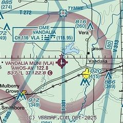
|
| Airport distance calculator |
|---|
|
|
| Sunrise and sunset |
|---|
|
Times for 14-Jul-2026
| | Local
(UTC-5) | | Zulu
(UTC) |
|---|
| Morning civil twilight | | 05:12 | | 10:12 |
| Sunrise | | 05:44 | | 10:44 |
| Sunset | | 20:21 | | 01:21 |
| Evening civil twilight | | 20:53 | | 01:53 |
|
| Current date and time |
|---|
| Zulu (UTC) | 14-Jul-2026 08:21:19 |
|---|
| Local (UTC-5) | 14-Jul-2026 03:21:19 |
|---|
|
| METAR |
|---|
KSLO
23nm SE | 140755Z 10SM CLR 23/20 A3016 RMK AO2 T02250198
|
K3LF
26nm NW | 140755Z AUTO 00000KT 7SM CLR 19/18 A3019 RMK AO2 T01850181
|
KENL
29nm S | 140755Z AUTO 00000KT 10SM CLR 20/19 A3016 RMK AO2 T01970187
|
K1H2
30nm E | 140755Z AUTO 00000KT 10SM CLR 22/21 A3018 RMK AO2 T02170205
|
KFOA
39nm SE | 140755Z AUTO 36005KT 10SM CLR 21/20 A3016 RMK AO2
|
KALN
41nm W | 140755Z AUTO 00000KT 7SM CLR 20/19 A3018 RMK AO2 T01980191
|
KBLV
42nm SW | 140755Z AUTO 01003KT 10SM CLR 22/21 A3014 RMK AO2 SLP205 T02200213 $
|
|
| TAF |
|---|
KBLV
42nm SW | 140000Z 1400/1506 05006KT 9999 SCT200 QNH3008INS TX33/1421Z TN19/1411Z
|
KMVN
43nm S | 140520Z 1406/1506 03002KT P6SM SKC FM141500 06006KT P6SM FEW040 FM150000 VRB03KT P6SM FEW250
|
|
| NOTAMs |
|---|
NOTAMs are issued by the DoD/FAA and will open in a separate window not controlled by AirNav.
|
|

