FAA INFORMATION EFFECTIVE 11 JUNE 2026
Location
| FAA Identifier: | 3N6 |
| Lat/Long: | 40-19-47.5920N 074-20-48.4330W
40-19.793200N 074-20.807217W
40.3298867,-74.3467869
(estimated) |
| Elevation: | 87 ft. / 27 m (estimated) |
| Variation: | 13W (2010) |
| From city: | 5 miles S of OLD BRIDGE, NJ |
| Time zone: | UTC -4 (UTC -5 during Standard Time) |
| Zip code: | 08831 |
Airport Operations
| Airport use: | Open to the public |
| Activation date: | 02/1966 |
| Control tower: | no |
| ARTCC: | NEW YORK CENTER |
| FSS: | MILLVILLE FLIGHT SERVICE STATION |
| NOTAMs facility: | MIV (NOTAM-D service available) |
| Attendance: | 0800-1700 |
| Wind indicator: | lighted |
| Segmented circle: | yes |
| Lights: | ACTVT REIL RWY 6 & 24; MIRL RWY 06/24 - CTAF. |
| Beacon: | white-green (lighted land airport)
ACTVT ROTG BCN - CTAF. |
Airport Communications
| CTAF/UNICOM: | 123.075 |
| MC GUIRE APPROACH: | 126.475 |
| MC GUIRE DEPARTURE: | 126.475 |
| WX AWOS-3PT at BLM (13 nm SE): | 121.625 (732-938-3330) |
| WX AWOS-AV at N12 (18 nm SE): | 122.8 (732-363-6471) |
| WX AWOS-3 at LDJ (18 nm N): | 124.025 (908-862-7383) |
Nearby radio navigation aids
| VOR radial/distance | | VOR name | | Freq | | Var |
|---|
| COLr288/8.6 | | COLTS NECK VOR/DME | | 115.40 | | 11W |
| RBVr052/10.2 | | ROBBINSVILLE VORTAC | | 113.80 | | 10W |
| GXUr043/22.4 | | MC GUIRE VORTAC | | 110.60 | | 12W |
| SBJr140/23.6 | | SOLBERG VOR/DME | | 112.90 | | 10W |
| ARDr090/26.1 | | YARDLEY VOR/DME | | 108.20 | | 10W |
| CRIr242/26.7 | | CANARSIE VOR/DME | | 112.30 | | 11W |
| CYNr017/31.0 | | COYLE VORTAC | | 113.40 | | 10W |
| JFKr247/31.9 | | KENNEDY VOR/DME | | 115.90 | | 12W |
| TEBr214/33.7 | | TETERBORO VOR/DME | | 108.40 | | 11W |
| LGAr231/34.9 | | LA GUARDIA VOR/DME | | 113.10 | | 12W |
| BWZr153/35.5 | | BROADWAY VOR/DME | | 114.20 | | 11W |
| NDB name | | Hdg/Dist | | Freq | | Var | | ID |
|---|
| LAKEHURST | | 009/17.1 | | 396 | | 11W | | NEL | -. . .-.. |
Airport Services
| Fuel available: | 100LL |
| Parking: | tiedowns |
| Airframe service: | MAJOR |
| Powerplant service: | MAJOR |
| Bottled oxygen: | NONE |
| Bulk oxygen: | NONE |
Runway Information
Runway 6/24
| Dimensions: | 3594 x 50 ft. / 1095 x 15 m |
| Surface: | asphalt, in fair condition |
| Runway edge lights: | medium intensity |
| RUNWAY 6 | | RUNWAY 24 |
| Latitude: | 40-19.581100N | | 40-20.004800N |
| Longitude: | 074-21.077000W | | 074-20.537000W |
| Elevation: | 63.0 ft. | | 86.0 ft. |
| Traffic pattern: | left | | right |
| Runway heading: | 057 magnetic, 044 true | | 237 magnetic, 224 true |
| Displaced threshold: | 600 ft. | | 400 ft. |
| Markings: | nonprecision, in fair condition | | nonprecision, in fair condition |
| Visual slope indicator: | 2-light PAPI on left (4.00 degrees glide path) | | 2-light PAPI on right (4.00 degrees glide path) |
| Runway end identifier lights: | yes | | yes |
| Touchdown point: | yes, no lights | | yes, no lights |
| Obstructions: | 80 ft. tree, 280 ft. from runway, 200 ft. right of centerline, 1:1 slope to clear
16 FT HNGR 53 FT FROM RWY END 200 FT L OF CNTRLN; 25 FT TREELINE 125 FT FROM RWY END ACRS CNTRLN. | | 40 ft. tree, 400 ft. from runway, 135 ft. left of centerline, 5:1 slope to clear
APCH SLOPE 20:1 TO DSPLCD THLD. |
Airport Ownership and Management from official FAA records
| Ownership: | Privately-owned |
| Owner: | MADISON INC.
182 PENSION RD
ENGLISHTOWN, NJ 07726
Phone 732-446-0303 |
| Manager: | PAUL CERNIGLIA
182 PENSION RD
ENGLISHTOWN, NJ 07726
Phone 732-718-0444 |
Additional Remarks
| - | NO TOUCH & GO. |
| - | GCO AVBL ON FREQ 121.725 THRU MIV RADIO. |
| - | DRAG STRIP PARK & TREES E/W OF ARPT & INVOF APCH END RWY 6/24. |
| - | FOR CD USE GCO 121.725, IF UNABLE CTC MC GUIRE APCH AT 609-754-2767. |
| - | DEER & BIRDS ON & INVOF ARPT. |
| - | TWYS FAIR COND, 2 IN CRACKS, 2 TO 3 IN DEEP, NEAR TWY HOLD SHORT LINES. TWY SFCS UNEVEN. ALL TWY MKGS FADED. |
Instrument Procedures
NOTE: All procedures below are presented as PDF files. If you need a reader for these files, you should download the free Adobe Reader.NOT FOR NAVIGATION. Please procure official charts for flight.
FAA instrument procedures published for use from 11 June 2026 at 0901Z to 09 July 2026 at 0900z.
IAPs - Instrument Approach Procedures |
|---|
| RNAV (GPS) RWY 06 | |
download (194KB) |
| RNAV (GPS) RWY 24 | |
download (197KB) |
| VOR RWY 24 | |
download (218KB) |
| NOTE: Special Take-Off Minimums/Departure Procedures apply | |
download (150KB) |
Other nearby airports with instrument procedures:
KBLM - Monmouth Executive Airport (13 nm SE)
N87 - Trenton-Robbinsville Airport (14 nm SW)
39N - Princeton Airport (15 nm W)
47N - Central Jersey Regional Airport (16 nm NW)
N12 - Lakewood Airport (18 nm SE)
KNEL - Lakehurst Maxfield Field Airport (18 nm S)
KLDJ - Linden Airport (18 nm N)
|
|

Road maps at:
MapQuest
Bing
Google
| Aerial photo |
|---|
WARNING: Photo may not be current or correct
 Photo by Coleen Abrams
Photo taken 30-Sep-2007
Photo by Coleen Abrams
Photo taken 30-Sep-2007
Do you have a better or more recent aerial photo of Old Bridge Airport that you would like to share? If so, please send us your photo.
|
| Sectional chart |
|---|
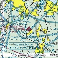
|
| Airport distance calculator |
|---|
|
|
| Sunrise and sunset |
|---|
|
Times for 07-Jul-2026
| | Local
(UTC-4) | | Zulu
(UTC) |
|---|
| Morning civil twilight | | 05:03 | | 09:03 |
| Sunrise | | 05:35 | | 09:35 |
| Sunset | | 20:29 | | 00:29 |
| Evening civil twilight | | 21:02 | | 01:02 |
|
| Current date and time |
|---|
| Zulu (UTC) | 07-Jul-2026 20:14:27 |
|---|
| Local (UTC-4) | 07-Jul-2026 16:14:27 |
|---|
|
| METAR |
|---|
KBLM
14nm SE | AWOS-3 121.625 732-938-3330
040029Z AUTO 34031G43KT 6SM VCTS HZ SQ SCT075 BKN120 34/19 A2998 RMK AO2 PK WND 33043/0027 LTG DSNT W-NE TSB29 PRESRR PNO $
|
KLDJ
18nm N | 071955Z AUTO 03007KT 10SM OVC021 23/17 A3002 RMK AO2 T02280173
|
KTTN
22nm W | ASOS 133.70 609-538-8690
071953Z 36006KT 10SM OVC014 22/18 A3001 RMK AO2 SLP155 T02220178 $
|
KWRI
22nm SW | 071955Z 35008KT 10SM OVC017 23/19 A3001 RMK AO2A SLP161 T02320187 PWINO $
|
KSMQ
23nm NW | ASOS 120.60 908-722-2139
071953Z AUTO VRB03KT 9SM OVC025 23/18 A3000 RMK AO2 SLP158 T02330178
|
KEWR
23nm N | 071951Z 36011KT 10SM OVC020 22/18 A3001 RMK AO2 SLP162 T02220178
|
KMJX
24nm S | AWOS-3 119.875 732-244-4450
071956Z AUTO 35008KT 10SM OVC015 22/18 A3001 RMK AO2 SLP167 T02220183 $
|
KJRB
27nm NE | 071956Z AUTO VRB03KT 10SM OVC016 22/ A3002 RMK AO2 PK WND 30038/1931 SLPNO T0222
|
KMMU
27nm N | 071945Z 04008KT 10SM OVC017 22/20 A3004
|
|
| TAF |
|---|
KTTN
22nm W | 071724Z 0718/0818 03007KT P6SM OVC012 FM080400 03005KT 6SM BR BKN010 FM081100 05006KT P6SM BKN020 FM081600 08006KT P6SM SCT030
|
KWRI
22nm SW | 071100Z 0711/0816 03008KT 9999 BKN004 OVC010 QNH2997INS BECMG 0714/0715 03010G15KT 9999 BKN012 OVC020 QNH2999INS TEMPO 0715/0718 8000 -SHRA BKN008 BECMG 0718/0719 05012G18KT 9999 BKN010 OVC025 QNH2998INS BECMG 0802/0803 VRB05KT 4800 BR BKN004 OVC010 QNH3001INS BECMG 0811/0812 06007KT 9999 NSW BKN010 OVC018 QNH3002INS TX23/0720Z TN20/0711Z
|
KEWR
23nm N | 071733Z 0718/0824 01010KT P6SM OVC012 FM080500 02007KT P6SM BKN025 FM080900 01008KT P6SM BKN035 FM081200 02006KT P6SM SCT060 FM082000 18006KT P6SM FEW200
|
|
| NOTAMs |
|---|
NOTAMs are issued by the DoD/FAA and will open in a separate window not controlled by AirNav.
|
|

