FAA INFORMATION EFFECTIVE 09 JULY 2026
Location
| FAA Identifier: | PTW |
| Lat/Long: | 40-14-22.4000N 075-33-24.2000W
40-14.373333N 075-33.403333W
40.2395556,-75.5567222
(estimated) |
| Elevation: | 308.2 ft. / 93.9 m (surveyed) |
| Variation: | 12W (1990) |
| From city: | 3 miles E of POTTSTOWN, PA |
| Time zone: | UTC -4 (UTC -5 during Standard Time) |
| Zip code: | 19464 |
Airport Operations
| Airport use: | Open to the public |
| Activation date: | 04/1938 |
| Control tower: | no |
| ARTCC: | NEW YORK CENTER |
| FSS: | WILLIAMSPORT FLIGHT SERVICE STATION |
| NOTAMs facility: | PTW (NOTAM-D service available) |
| Attendance: | MON-FRI 0700-2000, ALL SAT-SUN 0700-1800 |
| Wind indicator: | lighted |
| Segmented circle: | yes |
| Lights: | ACTVT MIRL RWY 10/28 - 122.7. |
| Beacon: | white-green (lighted land airport)
ACTVT ROTG BCN - 122.7. |
| Landing fee: | yes |
Airport Communications
| CTAF/UNICOM: | 122.7 |
| WX ASOS: | 119.425 (610-495-0823) |
| PHILADELPHIA APPROACH: | 126.85 |
| PHILADELPHIA DEPARTURE: | 126.85 |
| CLEARANCE DELIVERY: | 118.55 |
| WX AWOS-3 at UKT (14 nm NE): | 119.475 (215-538-7610) |
| WX AWOS-3 at LOM (15 nm SE): | 118.925 (215-646-1068) |
| WX AWOS-3T at OQN (15 nm S): | 121.4 ((610) 692-6190) |
| WX AWOS-3 at CKZ (15 nm NE): | 126.325 (215-257-7291) |
- CLEARANCE DELIVERY PHILADELPHIA APCH TF 800-354-9884.
Nearby radio navigation aids
| VOR radial/distance | | VOR name | | Freq | | Var |
|---|
| PTWr018/1.1 | | POTTSTOWN VORTAC | | 116.50 | | 09W |
| MXEr024/20.0 | | MODENA VORTAC | | 113.20 | | 09W |
| ETXr173/21.3 | | EAST TEXAS VOR/DME | | 110.20 | | 09W |
| FJCr199/29.6 | | ALLENTOWN VORTAC | | 117.50 | | 10W |
| ARDr278/29.7 | | YARDLEY VOR/DME | | 108.20 | | 10W |
| DQOr014/33.8 | | DUPONT VORTAC | | 114.00 | | 10W |
| LRPr087/34.4 | | LANCASTER VOR/DME | | 117.30 | | 09W |
| OODr352/38.0 | | WOODSTOWN VORTAC | | 112.80 | | 10W |
Airport Services
| Fuel available: | 100LL JET-A |
| Parking: | hangars and tiedowns |
| Airframe service: | MAJOR |
| Powerplant service: | MAJOR |
| Bottled oxygen: | NONE |
| Bulk oxygen: | NONE |
Runway Information
Runway 10/28
| Dimensions: | 3371 x 75 ft. / 1027 x 23 m |
| Surface: | asphalt, in good condition |
| Runway edge lights: | medium intensity |
| RUNWAY 10 | | RUNWAY 28 |
| Latitude: | 40-14.345305N | | 40-14.402280N |
| Longitude: | 075-33.763608W | | 075-33.042933W |
| Elevation: | 307.0 ft. | | 302.6 ft. |
| Traffic pattern: | left | | right |
| Runway heading: | 096 magnetic, 084 true | | 276 magnetic, 264 true |
| Displaced threshold: | no | | 190 ft. |
| Markings: | nonprecision, in good condition | | nonprecision, in good condition |
| Visual slope indicator: | 2-light PAPI on left (3.00 degrees glide path) | | 2-light PAPI on left (3.00 degrees glide path) |
| Runway end identifier lights: | yes | | yes |
| Touchdown point: | yes, no lights | | yes, no lights |
| Instrument approach: | | | LOCALIZER |
| Obstructions: | 14 ft. trees, 381 ft. from runway, 13 ft. left of centerline, 12:1 slope to clear | | 40 ft. trees, 576 ft. from runway, 269 ft. right of centerline, 9:1 slope to clear
10 FT ROAD 0-200 FT FM THR. |
Airport Ownership and Management from official FAA records
| Ownership: | Privately-owned |
| Owner: | LIMERICK AVIATION LP
3310 WEST RIDGE PIKE
POTTSTOWN, PA 19464
Phone 610-495-7000 |
| Manager: | JEFF HEACOCK
3310 WEST RIDGE PIKE
POTTSTOWN, PA 19464
Phone (610) 495-7000 |
Additional Remarks
| - | LGTD & MKD 507 FT AGL (769 FT MSL) STACK 6000 FT W OF RWY 10. |
| - | BIRDS & DEER ON & INVOF ARPT. |
| - | FOR CD CTC PHILADELPHIA APCH AT 800-354-9884. |
Instrument Procedures
NOTE: All procedures below are presented as PDF files. If you need a reader for these files, you should download the free Adobe Reader.NOT FOR NAVIGATION. Please procure official charts for flight.
FAA instrument procedures published for use from 09 July 2026 at 0901Z to 06 August 2026 at 0900Z.
IAPs - Instrument Approach Procedures |
|---|
| RNAV (GPS) RWY 28 | |
download (223KB) |
| RNAV (GPS)-A | |
download (167KB) |
| LOC RWY 28 | |
download (216KB) |
| VOR/DME-A | |
download (168KB) |
| NOTE: Special Alternate Minimums apply | |
download (123KB) |
| NOTE: Special Take-Off Minimums/Departure Procedures apply | |
download (428KB) |
Other nearby airports with instrument procedures:
N47 - Pottstown Municipal Airport (5 nm W)
KUKT - Quakertown Airport (14 nm NE)
KLOM - Wings Field Airport (15 nm SE)
KOQN - Brandywine Regional Airport (15 nm S)
KCKZ - Pennridge Airport (15 nm NE)
|
|

Road maps at:
MapQuest
Bing
Google
| Aerial photo |
|---|
WARNING: Photo may not be current or correct
 Photo by Aerial Sky Shots Photography - Amanda Rouiller
Photo taken 31-May-2014
looking north-northeast from 1,000FT.
Photo by Aerial Sky Shots Photography - Amanda Rouiller
Photo taken 31-May-2014
looking north-northeast from 1,000FT.
Do you have a better or more recent aerial photo of Heritage Field Airport that you would like to share? If so, please send us your photo.
|
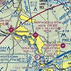
| Sectional chart |
|---|
|
| Airport distance calculator |
|---|
|
|
| Sunrise and sunset |
|---|
|
Times for 09-Jul-2026
| | Local
(UTC-4) | | Zulu
(UTC) |
|---|
| Morning civil twilight | | 05:09 | | 09:09 |
| Sunrise | | 05:42 | | 09:42 |
| Sunset | | 20:33 | | 00:33 |
| Evening civil twilight | | 21:05 | | 01:05 |
|
| Current date and time |
|---|
| Zulu (UTC) | 09-Jul-2026 09:42:16 |
|---|
| Local (UTC-4) | 09-Jul-2026 05:42:16 |
|---|
|
| METAR |
|---|
| KPTW | 090904Z AUTO 00000KT BKN021 BKN035 OVC110 21/19 A2997 RMK AO2 T02110194 PWINO $
|
KUKT
14nm NE | 090915Z AUTO 00000KT 10SM 19/19 A2997 RMK AO2
|
KLOM
15nm SE | 090915Z AUTO 00000KT 10SM SCT085 BKN110 21/20 A2996 RMK AO2 T02050201
|
KOQN
15nm S | 090915Z AUTO 00000KT 10SM SCT034 SCT110 21/20 A2998 RMK AO2
|
KCKZ
15nm NE | 090915Z AUTO 00000KT 5SM BR FEW013 SCT022 OVC120 19/19 A2997 RMK AO2
|
|
| TAF |
|---|
KRDG
20nm W | 090520Z 0906/1006 VRB03KT P6SM FEW035 FM091100 20005KT P6SM BKN015 FM091700 22007KT P6SM VCTS BKN045CB TEMPO 0918/0921 2SM TSRA BR FM092200 23005KT P6SM BKN100
|
|
| NOTAMs |
|---|
NOTAMs are issued by the DoD/FAA and will open in a separate window not controlled by AirNav.
|
|

