FAA INFORMATION EFFECTIVE 11 JUNE 2026
Location
| FAA Identifier: | N47 |
| Lat/Long: | 40-15-37.5000N 075-40-15.0000W
40-15.625000N 075-40.250000W
40.2604167,-75.6708333
(estimated) |
| Elevation: | 255.6 ft. / 77.9 m (surveyed) |
| Variation: | 12W (2010) |
| From city: | 2 miles NW of POTTSTOWN, PA |
| Time zone: | UTC -4 (UTC -5 during Standard Time) |
| Zip code: | 19464 |
Airport Operations
| Airport use: | Open to the public |
| Activation date: | 12/1946 |
| Control tower: | no |
| ARTCC: | NEW YORK CENTER |
| FSS: | WILLIAMSPORT FLIGHT SERVICE STATION |
| NOTAMs facility: | IPT (NOTAM-D service available) |
| Attendance: | UNATTND |
| Wind indicator: | lighted |
| Segmented circle: | no |
| Lights: | ACTVT MIRL RWY 08/26; REIL RWY 08/26 - CTAF 122.8. |
| Beacon: | white-green (lighted land airport) |
Airport Communications
| CTAF/UNICOM: | 122.8 |
| PHILADELPHIA APPROACH: | 126.85 |
| PHILADELPHIA DEPARTURE: | 126.85 |
| CLEARANCE DELIVERY: | 118.55 |
| WX ASOS at PTW (5 nm E): | 119.425 (610-495-0823) |
| WX ASOS at RDG (15 nm NW): | 127.1 (610-372-9863) |
| WX AWOS-3T at OQN (17 nm S): | 121.4 ((610) 692-6190) |
| WX AWOS-3 at UKT (17 nm NE): | 119.475 (215-538-7610) |
| WX AWOS-3 at CKZ (19 nm NE): | 126.325 (215-257-7291) |
| WX AWOS-3 at MQS (19 nm SW): | 126.25 (610-384-6132) |
- CLEARANCE DELIVERY PHILADELPHIA APCH TF 800-354-9884.
Nearby radio navigation aids
| VOR radial/distance | | VOR name | | Freq | | Var |
|---|
| PTWr303/5.6 | | POTTSTOWN VORTAC | | 116.50 | | 09W |
| ETXr187/19.2 | | EAST TEXAS VOR/DME | | 110.20 | | 09W |
| MXEr009/20.5 | | MODENA VORTAC | | 113.20 | | 09W |
| LRPr082/29.7 | | LANCASTER VOR/DME | | 117.30 | | 09W |
| FJCr209/29.7 | | ALLENTOWN VORTAC | | 117.50 | | 10W |
| ARDr281/34.9 | | YARDLEY VOR/DME | | 108.20 | | 10W |
| DQOr005/35.1 | | DUPONT VORTAC | | 114.00 | | 10W |
Airport Services
| Fuel available: | 100LL |
| Parking: | tiedowns |
| Airframe service: | MAJOR |
| Powerplant service: | MAJOR |
| Bottled oxygen: | NONE |
| Bulk oxygen: | NONE |
Runway Information
Runway 8/26
| Dimensions: | 2704 x 75 ft. / 824 x 23 m |
| Surface: | asphalt, in good condition |
| Weight bearing capacity: | |
| Runway edge lights: | medium intensity |
| RUNWAY 8 | | RUNWAY 26 |
| Latitude: | 40-15.538155N | | 40-15.711323N |
| Longitude: | 075-40.518482W | | 075-39.982937W |
| Elevation: | 254.3 ft. | | 244.0 ft. |
| Traffic pattern: | left | | left |
| Runway heading: | 079 magnetic, 067 true | | 259 magnetic, 247 true |
| Displaced threshold: | 380 ft. | | no |
| Markings: | basic, in fair condition | | nonprecision, in fair condition |
| Visual slope indicator: | | | 2-light PAPI on left (3.75 degrees glide path) |
| Runway end identifier lights: | yes | | yes |
| Touchdown point: | yes, no lights | | yes, no lights |
| Obstructions: | 8 ft. tree, 234 ft. from runway, 114 ft. left of centerline, 4:1 slope to clear
APCH SLOPE 22:1 TO 380 FT DTHR. | | 10 ft. tree, 278 ft. from runway, 154 ft. left of centerline, 7:1 slope to clear
32 FT TREE 106 FT FM RWY END, 238 FT RIGHT. |
Airport Ownership and Management from official FAA records
| Ownership: | Publicly-owned |
| Owner: | BOROUGH OF POTTSTOWN
100 E HIGH ST
POTTSTOWN, PA 19464
Phone (610) 970-6511 |
| Manager: | CURTIS MEYER
1149 GLASGOW ST
POTTSTOWN, PA 19464
Phone 267-643-9958 |
Additional Remarks
| - | WILDLIFE ON & INVOF ARPT. |
| - | FOR SVC AFT HRS CTC AMGR. |
| - | FOR CD CTC PHILADELPHIA APCH AT 800-354-9884. |
Instrument Procedures
NOTE: All procedures below are presented as PDF files. If you need a reader for these files, you should download the free Adobe Reader.NOT FOR NAVIGATION. Please procure official charts for flight.
FAA instrument procedures published for use from 11 June 2026 at 0901Z to 09 July 2026 at 0900z.
IAPs - Instrument Approach Procedures |
|---|
| RNAV (GPS) RWY 26 | |
download (211KB) |
| NOTE: Special Take-Off Minimums/Departure Procedures apply | |
download (278KB) |
Other nearby airports with instrument procedures:
KPTW - Heritage Field Airport (5 nm E)
KRDG - Reading Regional Airport/Carl A Spaatz Field (15 nm NW)
KOQN - Brandywine Regional Airport (17 nm S)
KUKT - Quakertown Airport (17 nm NE)
KCKZ - Pennridge Airport (19 nm NE)
KMQS - Chester County G O Carlson Airport (19 nm SW)
KLOM - Wings Field Airport (20 nm E)
|
|

Road maps at:
MapQuest
Bing
Google
| Aerial photo |
|---|
WARNING: Photo may not be current or correct
 Photo by David Newcomer
Photo taken 04-Feb-2017
from 3,000 altitude looking south.
Photo by David Newcomer
Photo taken 04-Feb-2017
from 3,000 altitude looking south.
Do you have a better or more recent aerial photo of Pottstown Municipal Airport that you would like to share? If so, please send us your photo.
|
| Sectional chart |
|---|
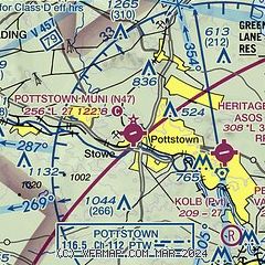
|
| Airport distance calculator |
|---|
|
|
| Sunrise and sunset |
|---|
|
Times for 23-Jun-2026
| | Local
(UTC-4) | | Zulu
(UTC) |
|---|
| Morning civil twilight | | 05:01 | | 09:01 |
| Sunrise | | 05:35 | | 09:35 |
| Sunset | | 20:35 | | 00:35 |
| Evening civil twilight | | 21:08 | | 01:08 |
|
| Current date and time |
|---|
| Zulu (UTC) | 23-Jun-2026 14:58:53 |
|---|
| Local (UTC-4) | 23-Jun-2026 10:58:53 |
|---|
|
| METAR |
|---|
KPTW
6nm E | 231454Z AUTO 32004KT 7SM -RA SCT011 BKN032 OVC100 18/17 A2993 RMK AO2 SLP133 P0006 60008 T01830172 51014
|
KRDG
15nm NW | 231454Z 34006KT 5SM RA BR BKN019 OVC080 18/17 A2993 RMK AO2 SLP137 P0006 60010 T01830167 51013
|
KOQN
17nm S | 231435Z AUTO 35007KT 10SM -RA BKN010 19/17 A2992 RMK AO2 P0002
|
KUKT
17nm NE | 231435Z AUTO 34004KT 5SM -RA FEW018 BKN038 18/18 A2992 RMK AO2
|
KCKZ
19nm NE | 231435Z AUTO 35006KT 4SM -RA BKN010 BKN014 OVC034 18/18 A2992 RMK AO2
|
KMQS
19nm SW | 231435Z AUTO 02005KT 4SM -RA BR BKN005 OVC010 19/19 A2992 RMK AO2 CIG 004V008 P0006 T01880188
|
|
| TAF |
|---|
KRDG
15nm NW | 231127Z 2312/2412 36007KT 6SM -SHRA BR OVC013 FM232000 35006KT P6SM VCSH SCT015 OVC023 FM232300 01007KT P6SM BKN040 FM240300 34010G18KT P6SM FEW240 FM240900 31007KT P6SM SKC
|
|
| NOTAMs |
|---|
NOTAMs are issued by the DoD/FAA and will open in a separate window not controlled by AirNav.
|
|

