FAA INFORMATION EFFECTIVE 11 JUNE 2026
Location
| FAA Identifier: | SRQ |
| Lat/Long: | 27-23-43.6000N 082-33-15.8000W
27-23.726667N 082-33.263333W
27.3954444,-82.5543889
(estimated) |
| Elevation: | 29.9 ft. / 9.1 m (surveyed) |
| Variation: | 05W (2010) |
| From city: | 3 miles N of central business district of the associated city |
| Time zone: | UTC -4 (UTC -5 during Standard Time) |
| Zip code: | 34243 |
Airport Operations
| Airport use: | Open to the public |
| Activation date: | 04/1942 |
| Control tower: | yes |
| ARTCC: | MIAMI CENTER |
| FSS: | SAINT PETERSBURG FLIGHT SERVICE STATION |
| NOTAMs facility: | SRQ (NOTAM-D service available) |
| Attendance: | CONTINUOUS |
| Wind indicator: | lighted |
| Segmented circle: | no |
| Lights: | WHEN ATCT CLSD ACTVT MALSR RWY 14 & 32; REIL RWY 22; PAPI RWY 04, 22, 14 & 32; HIRL RWY 04/22 & 14/32 - CTAF. |
| Beacon: | white-green (lighted land airport)
Operates sunset to sunrise. |
| Fire and rescue: | ARFF index C |
| International operations: | PPR US CUSTOMS USER FEE ARPT; SVC MON-FRI 0830-1630 -
813-634-1369. FEE PAYABLE ON SITE. |
Airport Communications
| CTAF: | 120.1 |
| UNICOM: | 122.95 |
| ATIS: | 124.375 |
| WX ASOS: | 124.375 (941-355-8482) |
| SARASOTA GROUND: | 121.9 273.6 [0600-0000] |
| SARASOTA TOWER: | 120.1 256.8 [0600-0000] |
| TAMPA APPROACH: | 119.65 124.95 |
| TAMPA DEPARTURE: | 119.65 124.95 |
| CLEARANCE DELIVERY: | 118.25 |
| BANGZ STAR: | 118.8 |
| CLASS C: | 119.65 |
| CLASS C/S: | 124.95 |
| LUBBR STAR: | 135.5 |
| RAYZZ STAR: | 118.8 |
- TAMPA APCH/DEP FREQS USABLE 4000' & BELOW.
Nearby radio navigation aids
| VOR radial/distance | | VOR name | | Freq | | Var |
|---|
| SRQ at field | | SARASOTA VOR/DME | | 117.00 | | 05W |
| PIEr172/31.5 | | ST PETERSBURG VORTAC | | 116.40 | | 05W |
Airport Services
| Fuel available: | 100LL JET-A
100LL:FOR FUEL AVBL CTC FBO. ACR FUEL SVC UNAVBL AFT LAST SKED DEP. 24 HR 100LL SELF SVC FUEL AVBL AT NORTH FBO. |
| Parking: | hangars and tiedowns |
| Airframe service: | MAJOR |
| Powerplant service: | MAJOR |
| Bottled oxygen: | HIGH/LOW |
| Bulk oxygen: | HIGH/LOW |
Runway Information
Runway 14/32
| Dimensions: | 9500 x 150 ft. / 2896 x 46 m |
| Surface: | asphalt/grooved, in fair condition |
| Weight bearing capacity: | | Single wheel: | 99.0 | | Double wheel: | 172.0 | | Double tandem: | 316.0 |
|
| Runway edge lights: | high intensity |
| RUNWAY 14 | | RUNWAY 32 |
| Latitude: | 27-24.277328N | | 27-23.180700N |
| Longitude: | 082-33.938605W | | 082-32.683168W |
| Elevation: | 26.2 ft. | | 29.9 ft. |
| Traffic pattern: | left | | left |
| Runway heading: | 139 magnetic, 134 true | | 319 magnetic, 314 true |
| Displaced threshold: | 1350 ft. | | 1150 ft. |
| Declared distances: | TORA:8350 TODA:9500 ASDA:8890 LDA:7540 | | TORA:8150 TODA:9500 ASDA:8660 LDA:7510 |
| Markings: | precision, in fair condition | | precision, in fair condition |
| Visual slope indicator: | 4-light PAPI on left (3.00 degrees glide path) | | 4-light PAPI on left (3.00 degrees glide path) |
| Approach lights: | MALSR: 1,400 foot medium intensity approach lighting system with runway alignment indicator lights | | MALSR: 1,400 foot medium intensity approach lighting system with runway alignment indicator lights |
| Touchdown point: | yes, no lights | | yes, no lights |
| Instrument approach: | ILS | | ILS |
| Obstructions: | 20 ft. berm, 200 ft. from runway, 465 ft. right of centerline
BERM 20 FT TALL 200 FT BFR AER RWY 14 465 RIGHT OF CNTRLN. | | none |
Runway 4/22
| Dimensions: | 5006 x 150 ft. / 1526 x 46 m |
| Surface: | asphalt/grooved, in good condition |
| Weight bearing capacity: | | Single wheel: | 120.0 | | Double wheel: | 250.0 | | Double tandem: | 493.0 | | Dual double tandem: | 999.0 |
|
| Runway edge lights: | high intensity |
| RUNWAY 4 | | RUNWAY 22 |
| Latitude: | 27-23.399125N | | 27-24.049238N |
| Longitude: | 082-33.458875W | | 082-32.887595W |
| Elevation: | 21.9 ft. | | 24.2 ft. |
| Traffic pattern: | left | | left |
| Runway heading: | 043 magnetic, 038 true | | 223 magnetic, 218 true |
| Declared distances: | TORA:5006 TODA:5006 ASDA:5006 LDA:5006 | | TORA:5006 TODA:5006 ASDA:5006 LDA:5006 |
| Markings: | nonprecision, in fair condition | | nonprecision, in fair condition |
| Visual slope indicator: | 4-light PAPI on left (3.00 degrees glide path) | | 4-light PAPI on left (3.00 degrees glide path) |
| Runway end identifier lights: | | | yes |
| Touchdown point: | yes, no lights | | yes, no lights |
| Obstructions: | none | | 15 ft. road, lighted, 335 ft. from runway, 270 ft. left of centerline, 9:1 slope to clear |
Airport Ownership and Management from official FAA records
| Ownership: | Publicly-owned |
| Owner: | SARASOTA MANATEE ARPT AUTHORITY
6000 AIRPORT CIRCLE
SARASOTA, FL 34243-2105
Phone (941) 359-2770 |
| Manager: | PAUL HOBACK, JR.
6000 AIRPORT CIRCLE
SARASOTA, FL 34243-2105
Phone 941-359-5200 |
Additional Remarks
| A39-14/32 | PCR VALUE: 370/F/A/X/T |
| A39-04/22 | PCR VALUE: 580/F/A/X/T |
| - | TWY F LTD TO 70000 LBS GWT. |
| - | FLD CONDS UNMON 0100-0530. |
| - | NO INTL FLT DVRSNS ACPTD UNLESS EMERG. |
| - | FOR CD IF UNA TO CTC ON FSS FREQ, CTC TAMPA APCH AT 813-878-2528. |
| - | ACFT RUN-UPS PROHIBITED AT TRML GATES. |
| - | US CUST GA ACFT AT W END OF TRML RAMP. |
| - | TRML GATE B1 UNAVBL TO ACFT WINGSPAN MORE THAN 118 FT. |
| - | TWY R5 CLSD TO ACFT WINGSPAN MORE THAN 118 FT. |
| - | 24 HR ADVN NOTICE OR IMT REPORTING UPON LDG FOR ACFT EQUIPPED WITH WEATHER MODIFICATION OR GEOENGINEERING EQUIP CTC ARPT OPS 941-359-2770 X4300. |
| - | SAID IN USE. OPER TRANSPONDERS WITH ALT REPORTING MODE AND ADS-B (IF EQUIPPED) ENABLED ON ALL ARPT SFC. |
| - | STRICT NOISE ABATEMENT PROC IN EFCT FOR DEP JET ACFT. |
| - | BIRDS ON & INVOF ARPT. |
| - | MISC: CLASS C ASP EFF 700-0100 ++; OT CLASS G. CLASS E 700 FT AGL & ABV. |
| - | TRML RAMP IS UNCTLD. DO NOT CALL FOR PUSH/POWER BACK. ADZ GC WHEN READY TO TAXI. |
| - | WHEN TWR CLSD HOLD AT ILS HOLD PSN SIGNS ABEAM RWY 14 & RWY 32 THR DURG ALL WX CONDS. APCH TO RWY 14 & RWY 32 CSDRD CLEAR WHEN ACFT ARE BYD RWY 14 & RWY 32 THR BASE UPON LDG DRCTN. |
| - | DIVD ACR ACFT ADZD TO USE TRML RAMP. |
| - | PPR FOR HIGH SPEED TAXI TEST - ARPT OPS 941-359-2770 EXT 4300. |
Instrument Procedures
NOTE: All procedures below are presented as PDF files. If you need a reader for these files, you should download the free Adobe Reader.NOT FOR NAVIGATION. Please procure official charts for flight.
FAA instrument procedures published for use from 11 June 2026 at 0901Z to 09 July 2026 at 0900z.
STARs - Standard Terminal Arrivals |
|---|
| BANGZ TWO (RNAV) **NEW** | |
2 pages:
[1] [2] (422KB) |
| LUBBR FOUR (RNAV) **NEW** | |
2 pages:
[1] [2] (418KB) |
| RAYZZ THREE (RNAV) **NEW** | |
2 pages:
[1] [2] (441KB) |
IAPs - Instrument Approach Procedures |
|---|
| ILS OR LOC RWY 14 | |
download (346KB) |
| ILS OR LOC RWY 32 | |
download (334KB) |
| RNAV (GPS) RWY 04 | |
download (283KB) |
| RNAV (GPS) RWY 14 | |
download (301KB) |
| RNAV (GPS) RWY 22 | |
download (255KB) |
| RNAV (GPS) RWY 32 | |
download (303KB) |
| NOTE: Special Alternate Minimums apply | |
download (41KB) |
Departure Procedures |
|---|
| SARASOTA SIX | |
download (186KB) |
| TIDES ONE (RNAV) | |
2 pages:
[1] [2] (387KB) |
| NOTE: Special Take-Off Minimums/Departure Procedures apply | |
download (415KB) |
Other nearby airports with instrument procedures:
KVNC - Venice Municipal Airport (20 nm S)
KSPG - Albert Whitted Airport (23 nm N)
KMCF - MacDill Air Force Base (27 nm N)
KPIE - St Pete-Clearwater International Airport (32 nm N)
KTPF - Peter O Knight Airport (32 nm N)
|
|

Road maps at:
MapQuest
Bing
Google
| Aerial photo |
|---|
WARNING: Photo may not be current or correct
 Photo courtesy of PhotosFromTheAir.com
Photo taken 11-Feb-2014
looking south from 7,000 ft.
Photo courtesy of PhotosFromTheAir.com
Photo taken 11-Feb-2014
looking south from 7,000 ft.
Do you have a better or more recent aerial photo of Sarasota/Bradenton International Airport that you would like to share? If so, please send us your photo.
|
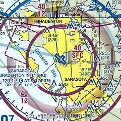
| Sectional chart |
|---|
|
CAUTION: Diagram may not be current
 Download PDF
of official airport diagram from the FAA
| Airport distance calculator |
|---|
|
|
| Sunrise and sunset |
|---|
|
Times for 19-Jun-2026
| | Local
(UTC-4) | | Zulu
(UTC) |
|---|
| Morning civil twilight | | 06:10 | | 10:10 |
| Sunrise | | 06:36 | | 10:36 |
| Sunset | | 20:27 | | 00:27 |
| Evening civil twilight | | 20:53 | | 00:53 |
|
| Current date and time |
|---|
| Zulu (UTC) | 19-Jun-2026 15:09:49 |
|---|
| Local (UTC-4) | 19-Jun-2026 11:09:49 |
|---|
|
| METAR |
|---|
| KSRQ | 191453Z 23011KT 10SM FEW019 FEW024 FEW030 32/26 A3006 RMK AO2 SLP177 T03220256 51004
|
|
| TAF |
|---|
| KSRQ | 191120Z 1912/2012 19007KT P6SM SCT120 BKN250 FM191600 23011KT P6SM SCT040 BKN250 FM192100 27009KT P6SM FEW050 BKN250 FM200200 VRB04KT P6SM FEW040 BKN250
|
|
| NOTAMs |
|---|
NOTAMs are issued by the DoD/FAA and will open in a separate window not controlled by AirNav.
|
|


