FAA INFORMATION EFFECTIVE 11 JUNE 2026
Location
| FAA Identifier: | SPG |
| Lat/Long: | 27-45-54.4110N 082-37-36.9830W
27-45.906850N 082-37.616383W
27.7651142,-82.6269397
(estimated) |
| Elevation: | 6.6 ft. / 2.0 m (surveyed) |
| Variation: | 05W (2010) |
| Time zone: | UTC -4 (UTC -5 during Standard Time) |
| Zip code: | 33701 |
Airport Operations
| Airport use: | Open to the public |
| Activation date: | 04/1940 |
| Control tower: | yes |
| ARTCC: | MIAMI CENTER |
| FSS: | SAINT PETERSBURG FLIGHT SERVICE STATION |
| NOTAMs facility: | SPG (NOTAM-D service available) |
| Attendance: | 0600-2100 |
| Pattern altitude: | 806.6 ft. MSL |
| Wind indicator: | lighted |
| Segmented circle: | yes |
| Lights: | ACTVT MIRL RWY 18/36 & RWY 07/25 - CTAF, REIL RWYS 7, 25, & 36 ACTVT WHEN MIRL ACTVT, REIL RWY 18 ONLY ACTVT ON STEP 3 MIRL, PAPI RWYS 07, 25, 18 & 36 OPERATE CONTINUOUSLY. |
| Beacon: | white-green (lighted land airport)
Operates sunset to sunrise. |
Airport Communications
| CTAF: | 127.4 |
| UNICOM: | 122.95 |
| WX ASOS: | 118.875 (727-821-4334) |
| WHITTED GROUND: | 121.8 [0700-2100] |
| WHITTED TOWER: | 127.4 257.6 [0700-2100] |
| TAMPA APPROACH: | 119.65 ;EAST 125.3 ;WEST |
| TAMPA DEPARTURE: | 119.65 ;EAST 125.3 ;WEST |
| WX ASOS at PIE (9 nm N): | 134.5 (727-502-6385) |
| WX AWOS-3 at TPF (13 nm NE): | 118.925 (813-251-6824) |
| WX ASOS at TPA (14 nm N): | 126.45 (813-296-2752) |
| WX AWOS-3P at CLW (15 nm NW): | 119.225 (727-462-6383) |
- FREQ 121.5 NOT MONITORED.
Nearby radio navigation aids
| VOR radial/distance | | VOR name | | Freq | | Var |
|---|
| PIEr165/9.1 | | ST PETERSBURG VORTAC | | 116.40 | | 05W |
| SRQr356/21.7 | | SARASOTA VOR/DME | | 117.00 | | 05W |
| LALr247/35.1 | | LAKELAND VORTAC | | 116.00 | | 01E |
| NDB name | | Hdg/Dist | | Freq | | Var | | ID |
|---|
| CAPOK | | 169/14.4 | | 360 | | 05W | | PI | .--. .. |
Airport Services
| Fuel available: | 100LL JET-A JET-A1 |
| Parking: | hangars and tiedowns |
| Airframe service: | MAJOR |
| Powerplant service: | MAJOR |
| Bottled oxygen: | LOW |
| Bulk oxygen: | NONE |
Runway Information
Runway 7/25
| Dimensions: | 3676 x 75 ft. / 1120 x 23 m |
| Surface: | asphalt, in good condition |
| Weight bearing capacity: | | PCN 9 /F/B/X/T | | Single wheel: | 60.0 | | Double wheel: | 105.0 | | Double tandem: | 190.0 |
|
| Runway edge lights: | medium intensity |
| RUNWAY 7 | | RUNWAY 25 |
| Latitude: | 27-45.790660N | | 27-46.074572N |
| Longitude: | 082-38.017410W | | 082-37.414643W |
| Elevation: | 5.3 ft. | | 5.9 ft. |
| Traffic pattern: | right | | left |
| Runway heading: | 067 magnetic, 062 true | | 247 magnetic, 242 true |
| Displaced threshold: | 557 ft. | | 263 ft. |
| Declared distances: | TORA:3646 TODA:3646 ASDA:3376 LDA:2849 | | TORA:3180 TODA:3180 ASDA:3312 LDA:3042 |
| Markings: | nonprecision, in fair condition | | basic, in fair condition |
| Visual slope indicator: | 2-light PAPI on left (3.31 degrees glide path) | | 2-light PAPI on left (3.90 degrees glide path) |
| Runway end identifier lights: | yes | | yes |
| Touchdown point: | yes, no lights | | yes, no lights |
| Obstructions: | 19 ft. bldg, 201 ft. from runway
19 FT BLAST FENCE AT RWY END, 15 FT STREET 5 FT FM RWY END, 24 FT BLDG 100 FT FM RWY END. | | 52 ft. boat, 1020 ft. from runway, 15:1 slope to clear
RWY 25 APCH RATIO 25:1 FM DTHR. |
Runway 18/36
| Dimensions: | 2864 x 75 ft. / 873 x 23 m |
| Surface: | asphalt, in excellent condition |
| Weight bearing capacity: | | PCN 14 /F/A/X/T | | Single wheel: | 60.0 | | Double wheel: | 105.0 | | Double tandem: | 190.0 |
|
| Runway edge lights: | medium intensity |
| RUNWAY 18 | | RUNWAY 36 |
| Latitude: | 27-46.110058N | | 27-45.637447N |
| Longitude: | 082-37.490172W | | 082-37.486775W |
| Elevation: | 5.3 ft. | | 4.6 ft. |
| Traffic pattern: | left | | right |
| Runway heading: | 185 magnetic, 180 true | | 005 magnetic, 360 true |
| Displaced threshold: | 190 ft. | | 115 ft. |
| Declared distances: | TORA:2864 TODA:2864 ASDA:2749 LDA:2559 | | TORA:2864 TODA:2864 ASDA:2674 LDA:2559 |
| Markings: | nonprecision, in good condition | | nonprecision, in good condition |
| Visual slope indicator: | 2-light PAPI on right (4.00 degrees glide path) | | 2-light PAPI on left (4.00 degrees glide path) |
| Runway end identifier lights: | yes | | yes |
| Touchdown point: | yes, no lights | | yes, no lights |
| Obstructions: | 40 ft. boat, marked and lighted, 1000 ft. from runway, 20:1 slope to clear
RWY 18 APRCH SLP 29:1 TO DTHR. | | 37 ft. boat, 614 ft. from runway, 11:1 slope to clear |
Airport Ownership and Management from official FAA records
| Ownership: | Publicly-owned |
| Owner: | CITY OF ST PETERSBURG
107 8TH AVENUE, S.E.
ST PETERSBURG, FL 33701
Phone 727-892-5715 |
| Manager: | RICH LESNIAK
ALBERT WHITTED AIRPORT, 107 8TH AVENUE SOUTHEAST
ST PETERSBURG, FL 33701
Phone 727-893-7657 |
Additional Remarks
| A30A-25 | TGL NA. |
| A30A-36 | SHIP CHANNEL & OCEAN VESSELS IN APCH AREA. |
| - | +/- 100 FT LIT/UNLIT BOAT MASTS IN RWY 18, 25 & 36 APCH AREA. |
| - | EMERG HELI WITH ROTG BCN 1/2 MI W OF ARPT. |
| - | WHEN ATCT CLSD; FOR CD CTC TAMPA APCH - 813-878-2528. |
| - | BANNER TOWING E OF RWY 18/36. |
| - | BIRDS ON & INVOF ARPT; GULLS ON RWY DURG INCLEMENT WX. |
| - | OCEAN VESSELS IN SHIP CHANNELS. |
| - | ALERT - HEAVY JET ACFT INVOF ARPT 1600 FT & ABV. |
Instrument Procedures
NOTE: All procedures below are presented as PDF files. If you need a reader for these files, you should download the free Adobe Reader.NOT FOR NAVIGATION. Please procure official charts for flight.
FAA instrument procedures published for use from 11 June 2026 at 0901Z to 09 July 2026 at 0900z.
STARs - Standard Terminal Arrivals |
|---|
| BANGZ TWO (RNAV) **NEW** | |
2 pages:
[1] [2] (422KB) |
| BLFRG THREE (RNAV) **NEW** | |
2 pages:
[1] [2] (299KB) |
| DADES TWO (RNAV) **NEW** | |
2 pages:
[1] [2] (426KB) |
| RAYZZ THREE (RNAV) **NEW** | |
2 pages:
[1] [2] (441KB) |
IAPs - Instrument Approach Procedures |
|---|
| RNAV (GPS) RWY 07 | |
download (234KB) |
| RNAV (GPS) RWY 18 | |
download (233KB) |
| RNAV (GPS) RWY 36 | |
download (206KB) |
| NOTE: Special Alternate Minimums apply | |
download (147KB) |
| NOTE: Special Take-Off Minimums/Departure Procedures apply | |
download (411KB) |
Other nearby airports with instrument procedures:
KMCF - MacDill Air Force Base (8 nm NE)
KPIE - St Pete-Clearwater International Airport (9 nm N)
KTPF - Peter O Knight Airport (13 nm NE)
KTPA - Tampa International Airport (14 nm N)
KCLW - Clearwater Executive Airport (15 nm NW)
|
|

Road maps at:
MapQuest
Bing
Google
| Aerial photo |
|---|
WARNING: Photo may not be current or correct
 Photo by Richard Lesniak
Taken in April 2018
looking north.
Photo by Richard Lesniak
Taken in April 2018
looking north.
Do you have a better or more recent aerial photo of Albert Whitted Airport that you would like to share? If so, please send us your photo.
|
| Sectional chart |
|---|
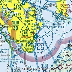
|
CAUTION: Diagram may not be current
 Download PDF
of official airport diagram from the FAA
| Airport distance calculator |
|---|
|
|
| Sunrise and sunset |
|---|
|
Times for 02-Jul-2026
| | Local
(UTC-4) | | Zulu
(UTC) |
|---|
| Morning civil twilight | | 06:13 | | 10:13 |
| Sunrise | | 06:40 | | 10:40 |
| Sunset | | 20:29 | | 00:29 |
| Evening civil twilight | | 20:56 | | 00:56 |
|
| Current date and time |
|---|
| Zulu (UTC) | 02-Jul-2026 06:17:32 |
|---|
| Local (UTC-4) | 02-Jul-2026 02:17:32 |
|---|
|
| METAR |
|---|
| KSPG | 020553Z AUTO 08015KT 10SM FEW032 28/26 A3000 RMK AO2 SLP157 T02780261 10283 20272 50005
|
KMCF
8nm NE | 020555Z AUTO 07010KT 10SM CLR 26/24 A2999 RMK AO2 SLP158 60000 T02640240 10272 20251 50003
|
KPIE
10nm N | 020553Z AUTO 07008KT 10SM CLR 27/24 A3001 RMK AO2 SLP163 T02670244 10272 20261 50003
|
KTPF
13nm NE | 020555Z AUTO 05007KT 10SM CLR 25/24 A3000 RMK AO2 T02520243 10260 20252 50004 $
|
KTPA
13nm N | 020553Z 05005KT 10SM FEW250 26/23 A3002 RMK AO2 SLP165 T02560233 10267 20256 50003 $
|
KCLW
15nm NW | 020555Z AUTO 09003KT 25/23 A3001 RMK AO2
|
|
| TAF |
|---|
KMCF
8nm NE | 020100Z 0201/0307 06006KT 9999 FEW090 SCT200 QNH2996INS BECMG 0218/0219 VRB10G15KT 9999 VCTS BKN050CB OVC080 QNH2998INS TEMPO 0219/0222 VRB15G20KT 4800 TSRA OVC030CB BECMG 0301/0302 15006KT 9999 NSW BKN040 QNH3001INS TEMPO 0303/0305 8000 -SHRA BECMG 0305/0306 11006KT 9999 SCT060 QNH3001INS TX34/0218Z TN25/0208Z
|
KPIE
10nm N | 020521Z 0206/0306 10005KT P6SM FEW250 FM021900 06006KT P6SM VCTS SCT040CB BKN250 TEMPO 0220/0223 VRB15G25KT 2SM TSRA BKN030CB FM030100 08005KT P6SM FEW040 BKN250
|
KTPA
13nm N | 020303Z 0203/0306 VRB03KT P6SM FEW100 SCT250 FM021400 09005KT P6SM SCT030 SCT250 FM021900 24008KT P6SM VCTS SCT035CB BKN250 TEMPO 0219/0222 VRB15G25KT 2SM TSRA BKN030CB FM030100 07005KT P6SM FEW040 SCT120 BKN250
|
|
| NOTAMs |
|---|
NOTAMs are issued by the DoD/FAA and will open in a separate window not controlled by AirNav.
|
|


