FAA INFORMATION EFFECTIVE 04 SEPTEMBER 2025
Location
| FAA Identifier: | T56 |
| Lat/Long: | 32-30-46.1240N 096-55-36.3965W
32-30.768733N 096-55.606608W
32.5128122,-96.9267768
(estimated) |
| Elevation: | 780 ft. / 238 m (estimated) |
| Variation: | 06E (1985) |
| From city: | 4 miles NE of MIDLOTHIAN, TX |
| Time zone: | UTC -5 (UTC -6 during Standard Time) |
| Zip code: | 76065 |
Airport Operations
| Airport use: | Open to the public |
| Activation date: | 02/1985 |
| Control tower: | no |
| ARTCC: | FORT WORTH CENTER |
| FSS: | FORT WORTH FLIGHT SERVICE STATION |
| NOTAMs facility: | FTW (NOTAM-D service available) |
| Attendance: | UNATNDD |
| Wind indicator: | yes |
| Segmented circle: | no |
| Lights: | ACTVT MIRL RWY 17/35, REILS RWY 17 & 35, TRIL RWY 17 & 35 - 122.975. |
| Beacon: | white-green (lighted land airport)
Operates sunset to sunrise. |
Airport Communications
| CTAF: | 122.975 |
| WX AWOS-3P at JWY (3 nm S): | 119.575 (972-227-0471) |
| WX ASOS at RBD (11 nm N): | PHONE 214-330-5317 |
| WX AWOS-3PT at LNC (11 nm E): | 118.975 (972-227-0471) |
| WX ASOS at GKY (12 nm NW): | 127.375 (817-557-0251) |
| WX AWOS-3P at GPM (13 nm NW): | 118.475 (972-606-1433) |
| WX AWOS-3 at 49T (17 nm N): | 135.425 (214-670-1243) |
| WX AWOS-3PT at FWS (20 nm W): | 120.025 (817-426-4172) |
Nearby radio navigation aids
| VOR radial/distance | | VOR name | | Freq | | Var |
|---|
| TTTr159/22.1 | | MAVERICK VOR/DME | | 113.10 | | 06E |
| CVEr177/22.7 | | COWBOY VOR/DME | | 116.20 | | 06E |
| FUZr145/25.9 | | RANGER VORTAC | | 115.70 | | 06E |
Airport Services
Runway Information
Runway 17/35
| Dimensions: | 3216 x 36 ft. / 980 x 11 m |
| Surface: | concrete, in good condition |
| Runway edge lights: | medium intensity
STROBES MARK THRS. |
| Runway edge markings: | ARPT NAME & CTAF MKD ON RWY. |
| Operational restrictions: | RWY 35 RISES 12 FT FM PAVEMENT END TO DSPLCD THLD. |
| RUNWAY 17 | | RUNWAY 35 |
| Latitude: | 32-31.033950N | | 32-30.503517N |
| Longitude: | 096-55.606350W | | 096-55.606867W |
| Elevation: | 779.0 ft. | | 748.0 ft. |
| Traffic pattern: | left | | right |
| Displaced threshold: | 332 ft.
37 FT POLES 401 FT FM DSPLCD THR, 125 FT L & R OF CNTRLN. | | 272 ft. |
| Markings: | basic, in good condition | | basic, in good condition |
| Visual slope indicator: | tri-color VASI on left (5.00 degrees glide path) | | tri-color VASI on left (5.00 degrees glide path) |
| Runway end identifier lights: | yes | | yes |
| Obstructions: | 20 ft. trees, 201 ft. from runway, 40 ft. right of centerline
5 FT FENCE, 40 FT DSTC, 125 FT L/R; 15 RD, 51 FT DSTC, 125 FT L/R. | | 23 ft. road, 211 ft. from runway, 145 ft. left and right of centerline
35 FT TREES, 20 FT DSTC, 115 FT R. |
Airport Ownership and Management from official FAA records
| Ownership: | Privately-owned |
| Owner: | EAGLES NEST PROPERTY OWNERS ASSN
2510 FALCON WAY
MIDLOTHIAN, TX 76065
Phone 972-742-2751 |
| Manager: | JAMES BARTH
3121 FALCON WAY
MIDLOTHIAN, TX 76065
Phone 972-775-6403
PROP. OWNERS ASSN PRES. |
Additional Remarks
| - | FOR CD CTC FORT WORTH ARTCC AT 817-858-7584. |
| - | NO LINE OF SIGHT BETWEEN RWY ENDS. |
| - | ACTVT RWY LTS FOR ALL OPERATIONS DUE TO LINE OF SIGHT LIMITATIONS. |
Instrument Procedures
There are no published instrument procedures at T56.
Some nearby airports with instrument procedures:
KJWY - Mid-Way Regional Airport (3 nm S)
KRBD - Dallas Executive Airport (11 nm N)
KLNC - Lancaster Regional Airport (11 nm E)
KGKY - Arlington Municipal Airport (12 nm NW)
KGPM - Grand Prairie Municipal Airport (13 nm NW)
F41 - Ennis Municipal Airport (17 nm SE)
KFWS - Fort Worth Spinks Airport (20 nm W)
|
|

Road maps at:
MapQuest
Bing
Google
| Aerial photo |
|---|
WARNING: Photo may not be current or correct

Do you have a better or more recent aerial photo of Eagle's Nest Estates Airport that you would like to share? If so, please send us your photo.
|
| Sectional chart |
|---|
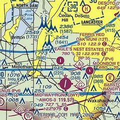
|
| Airport distance calculator |
|---|
|
|
| Sunrise and sunset |
|---|
|
Times for 20-Sep-2025
| | Local
(UTC-5) | | Zulu
(UTC) |
|---|
| Morning civil twilight | | 06:51 | | 11:51 |
| Sunrise | | 07:16 | | 12:16 |
| Sunset | | 19:27 | | 00:27 |
| Evening civil twilight | | 19:51 | | 00:51 |
|
| Current date and time |
|---|
| Zulu (UTC) | 20-Sep-2025 11:03:45 |
|---|
| Local (UTC-5) | 20-Sep-2025 06:03:45 |
|---|
|
| METAR |
|---|
KJWY
3nm S | 200355Z AUTO 12003KT 10SM CLR 25/21 A3002 RMK AO2 T02490209 $
|
KRBD
11nm N | 201053Z AUTO 19004KT 10SM CLR 22/20 A3000 RMK AO2 SLP151 T02220200
|
KLNC
11nm E | 201055Z AUTO 00000KT 21/20 A3002 RMK AO2 T02110200 PWINO
|
KGKY
13nm NW | 201053Z AUTO 17004KT 10SM CLR 23/20 A3000 RMK AO2 SLP149 T02330200
|
KGPM
13nm NW | 201055Z AUTO 20004KT 10SM CLR 24/19 A3002 RMK AO2 T02360190
|
KFWS
19nm W | 201055Z AUTO 19004KT 10SM CLR 21/19 A3001 RMK AO2 T02110186 $
|
|
| TAF |
|---|
KGKY
13nm NW | 200849Z 2009/2106 16009KT P6SM SCT070 BKN250
|
|
| NOTAMs |
|---|
NOTAMs are issued by the DoD/FAA and will open in a separate window not controlled by AirNav.
|
|


