FAA INFORMATION EFFECTIVE 14 MAY 2026
Location
| FAA Identifier: | 1M4 |
| Lat/Long: | 34-16-49.2000N 087-36-01.5000W
34-16.820000N 087-36.025000W
34.2803333,-87.6004167
(estimated) |
| Elevation: | 929.8 ft. / 283.4 m (surveyed) |
| Variation: | 01W (2000) |
| From city: | 3 miles NE of HALEYVILLE, AL |
| Time zone: | UTC -5 (UTC -6 during Standard Time) |
| Zip code: | 35565 |
Airport Operations
| Airport use: | Open to the public |
| Activation date: | 01/1959 |
| Control tower: | no |
| ARTCC: | MEMPHIS CENTER |
| FSS: | ANNISTON FLIGHT SERVICE STATION |
| NOTAMs facility: | ANB (NOTAM-D service available) |
| Attendance: | MON-FRI 0800-1700
FOR SVC AFT HRS CALL 205-494-9527, FUEL UNAVBL WKENDS EXC PRIOR APVL. |
| Wind indicator: | lighted |
| Segmented circle: | yes |
| Lights: | ACTVT REIL RWY 18 & 36; PAPI RWY 18 & 36; MIRL 18/36 - CTAF |
| Beacon: | white-green (lighted land airport)
Operates sunset to sunrise. |
Airport Communications
| CTAF/UNICOM: | 122.8 |
| WX AWOS-3PT: | 119.525 (205-486-0035) |
- APCH/DEP SVC PRVDD BY MEMPHIS ARTCC ON FREQS 120.8/307.0 (HUNTSVILLE RCAG).
Airport Services
| Fuel available: | 100LL JET-A+ |
| Parking: | tiedowns |
| Airframe service: | NONE |
| Powerplant service: | NONE |
| Bottled oxygen: | NONE |
| Bulk oxygen: | NONE |
Runway Information
Runway 18/36
| Dimensions: | 5008 x 100 ft. / 1526 x 30 m |
| Surface: | asphalt, in excellent condition |
| Weight bearing capacity: | |
| Runway edge lights: | medium intensity |
| RUNWAY 18 | | RUNWAY 36 |
| Latitude: | 34-17.232110N | | 34-16.406865N |
| Longitude: | 087-36.011102W | | 087-36.040325W |
| Elevation: | 929.8 ft. | | 902.7 ft. |
| Traffic pattern: | left | | left |
| Runway heading: | 183 magnetic, 182 true | | 003 magnetic, 002 true |
| Markings: | nonprecision, in good condition | | nonprecision, in good condition |
| Visual slope indicator: | 4-light PAPI on left (3.00 degrees glide path) | | 4-light PAPI on left (3.00 degrees glide path) |
| Runway end identifier lights: | yes | | yes |
| Touchdown point: | yes, no lights | | yes, no lights |
| Obstructions: | 45 ft. tree, 1067 ft. from runway, 331 ft. right of centerline, 19:1 slope to clear | | 53 ft. tree, 935 ft. from runway, 318 ft. left of centerline, 13:1 slope to clear |
Airport Ownership and Management from official FAA records
| Ownership: | Publicly-owned |
| Owner: | CITY OF HALEYVILLE
911 21ST STREET
HALEYVILLE, AL 35565
Phone 205-486-3121 |
| Manager: | BRYAN CRUMPTON
721 COUNTY RD 51
HALEYVILLE, AL 35565
Phone 205-486-8054 |
Additional Remarks
| A39-18/36 | PCR VALUE: 333/F/D/X/T |
| - | FOR CD CTC MEMPHIS ARTCC AT 901-368-8453/8449. |
| - | WIDESPREAD CRACKING AND VEGETATION GROWTH ON RAMP. |
Instrument Procedures
NOTE: All procedures below are presented as PDF files. If you need a reader for these files, you should download the free Adobe Reader.NOT FOR NAVIGATION. Please procure official charts for flight.
FAA instrument procedures published for use from 14 May 2026 at 0901Z to 11 June 2026 at 0900Z.
IAPs - Instrument Approach Procedures |
|---|
| RNAV (GPS) RWY 18 | |
download (250KB) |
| RNAV (GPS) RWY 36 | |
download (218KB) |
| NOTE: Special Alternate Minimums apply | |
download (157KB) |
| NOTE: Special Take-Off Minimums/Departure Procedures apply | |
download (490KB) |
Other nearby airports with instrument procedures:
M22 - Bill Pugh Field Airport (11 nm NW)
KHAB - Marion County-Rankin Fite Airport (22 nm SW)
9A4 - Courtland Airport (26 nm NE)
KJFX - Walker County Airport/Bevill Field (27 nm SE)
KMSL - Northwest Alabama Regional Airport (28 nm N)
|
|

Road maps at:
MapQuest
Bing
Google
| Aerial photo |
|---|
WARNING: Photo may not be current or correct
 Photo by Rob Wakefield
Photo taken 20-Nov-2008
Photo by Rob Wakefield
Photo taken 20-Nov-2008
Do you have a better or more recent aerial photo of Posey Field Airport that you would like to share? If so, please send us your photo.
|
| Sectional chart |
|---|
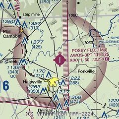
|
| Airport distance calculator |
|---|
|
|
| Sunrise and sunset |
|---|
|
Times for 22-May-2026
| | Local
(UTC-5) | | Zulu
(UTC) |
|---|
| Morning civil twilight | | 05:17 | | 10:17 |
| Sunrise | | 05:45 | | 10:45 |
| Sunset | | 19:49 | | 00:49 |
| Evening civil twilight | | 20:18 | | 01:18 |
|
| Current date and time |
|---|
| Zulu (UTC) | 22-May-2026 08:42:21 |
|---|
| Local (UTC-5) | 22-May-2026 03:42:21 |
|---|
|
| METAR |
|---|
| K1M4 | 220756Z AUTO 15004KT 10SM -RA BKN004 BKN008 OVC046 20/19 A2997 RMK AO2 SLP909 P0001 T02000194
|
|
| TAF |
|---|
KMSL
28nm N | 220520Z 2206/2306 VRB03KT P6SM OVC035 FM220700 VRB03KT 6SM BR VCSH OVC020 FM220900 15003KT 6SM -TSRA BR OVC007CB FM221400 17007G17KT 4SM -TSRA BR OVC005CB FM221800 18010G20KT 6SM TSRA BR OVC015CB FM230200 18004KT 6SM -TSRA BR OVC007CB
|
|
| NOTAMs |
|---|
NOTAMs are issued by the DoD/FAA and will open in a separate window not controlled by AirNav.
|
|

