FAA INFORMATION EFFECTIVE 09 JULY 2026
Location
| FAA Identifier: | 2J0 |
| Lat/Long: | 29-59-22.0400N 084-23-43.4100W
29-59.367333N 084-23.723500W
29.9894556,-84.3953917
(estimated) |
| Elevation: | 11 ft. / 3.4 m (surveyed) |
| Variation: | 01W (1985) |
| From city: | 3 miles S of PANACEA, FL |
| Time zone: | UTC -4 (UTC -5 during Standard Time) |
| Zip code: | 32346 |
Airport Operations
| Airport use: | Open to the public |
| Activation date: | 06/1966 |
| Control tower: | no |
| ARTCC: | JACKSONVILLE CENTER |
| FSS: | GAINESVILLE FLIGHT SERVICE STATION |
| NOTAMs facility: | GNV (NOTAM-D service available) |
| Attendance: | UNATNDD
GROUND ACCESS BY PRIOR REQUEST, 850-321-0373. |
| Wind indicator: | yes |
| Segmented circle: | no |
| Lights: | LGTS OTS |
Airport Communications
Nearby radio navigation aids
| VOR radial/distance | | VOR name | | Freq | | Var |
|---|
| SZWr180/34.0 | | SEMINOLE VORTAC | | 117.50 | | 02E |
Airport Services
| Parking: | tiedowns |
| Airframe service: | NONE |
| Powerplant service: | NONE |
| Bottled oxygen: | NONE |
| Bulk oxygen: | NONE |
Runway Information
Runway 18/36
| Dimensions: | 2590 x 70 ft. / 789 x 21 m |
| Surface: | turf, in fair condition
RY 18/36 SOFT TURF. |
| Runway edge markings: | RWY 18/36 LEN AND WID AND DSPLCD THLDS MKD WITH W PVC PIPES. |
| RUNWAY 18 | | RUNWAY 36 |
| Latitude: | 29-59.581000N | | 29-59.153667N |
| Longitude: | 084-23.723500W | | 084-23.723500W |
| Traffic pattern: | left | | left |
| Displaced threshold: | 200 ft. | | 375 ft. |
| Markings: | NSTD, in fair condition | | NSTD, in fair condition |
| Obstructions: | 15 ft. road, 102 ft. from runway, 125 ft. left of centerline, 6:1 slope to clear
RWY 36 APCH SLP 20:1 TO MKD DTHR. | | 35 ft. trees, 250 ft. from runway, 20 ft. left of centerline, 7:1 slope to clear |
Airport Ownership and Management from official FAA records
| Ownership: | Publicly-owned |
| Owner: | WAKULLA COUNTY
PO BOX 1263
CRAWFORDVILLE, FL 32326-1263
Phone 850-926-0919
CONTACT PERSON: DAVID EDWARDS |
| Manager: | STEVEN FULTS
35 MONOCOUPE CIRCLE
PANACEA, FL 32346
Phone 850-321-0373
ALT PHONE 850-321-0373 |
Additional Remarks
| - | AER 36 HAS 10-25 FT TREES AND 5 FT FENCE 90 FT EAST OF CNTRLN. |
| - | TREES, BLDGS, WINDSOCK POLES, LIGHTNING DETECTION SYSTEM, BERMS AND UTILITY POLES 75-125 FT EAST OF RY 18/36. |
| - | 50 FT TREES 100-125 FT WEST OF RWY 18/36 FULL LEN. |
| - | FOR CD CTC TALLAHASSEE APCH AT 850-942-8311, WHEN APCH CLSD CTC JACKSONVILLE ARTCC AT 904-845-1592. |
| - | 24 HR ADVN NOTICE OR IMT REPORTING UPON LDG FOR ACFT EQUIPPED WITH WEATHER MODIFICATION OR GEOENGINEERING EQUIP CTC ARPT OPS 850-321-0373. |
Instrument Procedures
There are no published instrument procedures at 2J0.
Some nearby airports with instrument procedures:
KTLH - Tallahassee International Airport (25 nm N)
KAAF - Apalachicola Regional Airport-Cleve Randolph Field (36 nm SW)
2J9 - Quincy Municipal Airport (37 nm N)
KFPY - Perry-Foley Airport (43 nm E)
70J - Cairo-Grady County Airport (55 nm N)
|
|

Road maps at:
MapQuest
Bing
Google
| Aerial photo |
|---|
WARNING: Photo may not be current or correct
 Taken in May 2016
looking northwest
Taken in May 2016
looking northwest
Do you have a better or more recent aerial photo of Wakulla County Airport that you would like to share? If so, please send us your photo.
|
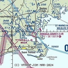
| Sectional chart |
|---|
|
| Airport distance calculator |
|---|
|
|
| Sunrise and sunset |
|---|
|
Times for 30-Jul-2026
| | Local
(UTC-4) | | Zulu
(UTC) |
|---|
| Morning civil twilight | | 06:30 | | 10:30 |
| Sunrise | | 06:56 | | 10:56 |
| Sunset | | 20:32 | | 00:32 |
| Evening civil twilight | | 20:58 | | 00:58 |
|
| Current date and time |
|---|
| Zulu (UTC) | 30-Jul-2026 09:16:27 |
|---|
| Local (UTC-4) | 30-Jul-2026 05:16:27 |
|---|
|
| METAR |
|---|
KTLH
25nm N | 300853Z AUTO 28006KT 10SM VCTS BKN055 OVC070 26/23 A2989 RMK AO2 LTG DSNT SW-N TSE20 SLP120 T02560233 55002
|
KAAF
37nm SW | 300853Z AUTO 26013G19KT 10SM CLR 26/23 A2987 RMK AO1 SLP114 T02610233 58008 TSNO $
|
K2J9
37nm N | 300855Z AUTO 00000KT 10SM VCTS FEW005 OVC055 24/24 A2992 RMK AO2 LTG DSNT ALQDS
|
KFPY
43nm E | 300855Z AUTO 00000KT 10SM SCT060 SCT075 SCT100 26/25 A2988 RMK AO2 LTG DSNT SW T02610253
|
|
| TAF |
|---|
KTLH
25nm N | 300538Z 3006/3106 23003KT P6SM VCSH SCT030 BKN070 OVC150 FM301000 29003KT 5SM BR SCT004 BKN030 FM301300 29004KT P6SM SCT020 BKN035 FM301700 26007KT P6SM VCSH SCT030 BKN050 BKN100 TEMPO 3020/3024 2SM TSRA BR BKN030CB BKN050 FM310300 27004KT P6SM SCT020 BKN040
|
|
| NOTAMs |
|---|
NOTAMs are issued by the DoD/FAA and will open in a separate window not controlled by AirNav.
|
|


