FAA INFORMATION EFFECTIVE 09 JULY 2026
Location
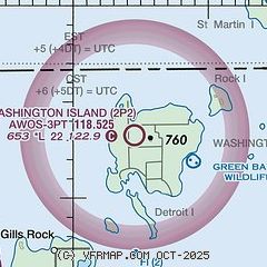
| FAA Identifier: | 2P2 |
| Lat/Long: | 45-23-17.7165N 086-55-26.5450W
45-23.295275N 086-55.442417W
45.3882546,-86.9240403
(estimated) |
| Elevation: | 652.5 ft. / 199 m (estimated) |
| Variation: | 04W (2000) |
| From city: | 1 mile S of WASHINGTON ISLAND, WI |
| Time zone: | UTC -5 (UTC -6 during Standard Time) |
| Zip code: | 54246 |
Airport Operations
| Airport use: | Open to the public |
| Activation date: | 02/1944 |
| Control tower: | no |
| ARTCC: | MINNEAPOLIS CENTER |
| FSS: | GREEN BAY FLIGHT SERVICE STATION |
| NOTAMs facility: | GRB (NOTAM-D service available) |
| Attendance: | UNATNDD |
| Wind indicator: | lighted, ACTVT WIND SOCK/WIND TEE - CTAF. |
| Segmented circle: | no |
| Lights: | LIRL RWY 02/20 OPR SS-SS AND PRESET TO LOW INTST; TO INCR INTST AND ACTVT LIRL RWY 02/20 & 14/32 - CTAF. |
| Beacon: | white-green (lighted land airport)
ACTVT ROTG BCN - CTAF. |
Airport Communications
| CTAF: | 122.9 |
| WX AWOS-3PT: | 118.525 (920 847 3024) |
| WX AWOS-3PT at 3D2 (19 nm SW): | 124.175 (920-854-5559) |
- APCH/DEP SVC PRVDD BY MINNEAPOLIS ARTCC ON FREQ 127.65 (ESCANABA RCAG).
Nearby radio navigation aids
| VOR radial/distance | | VOR name | | Freq | | Var |
|---|
| ESCr161/21.2 | | ESCANABA VOR/DME | | 113.55 | | 00E |
Airport Services
| Parking: | tiedowns |
| Airframe service: | NONE |
| Powerplant service: | NONE |
| Bottled oxygen: | NONE |
| Bulk oxygen: | NONE |
Runway Information
Runway 2/20
| Dimensions: | 2250 x 150 ft. / 686 x 46 m |
| Surface: | turf, in good condition |
| Runway edge lights: | low intensity |
| Runway edge markings: | MKD WITH YELLOW CONES. |
| RUNWAY 2 | | RUNWAY 20 |
| Latitude: | 45-23.071500N | | 45-23.407667N |
| Longitude: | 086-55.521500W | | 086-55.301167W |
| Elevation: | 650.4 ft. | | 643.1 ft. |
| Traffic pattern: | left | | left |
| Runway heading: | 029 magnetic, 025 true | | 209 magnetic, 205 true |
| Touchdown point: | yes, no lights | | yes, no lights |
| Obstructions: | 45 ft. trees, 750 ft. from runway, 200 ft. right of centerline, 16:1 slope to clear | | 32 ft. trees, 380 ft. from runway, 140 ft. left of centerline, 11:1 slope to clear |
Runway 14/32
| Dimensions: | 2232 x 150 ft. / 680 x 46 m |
| Surface: | turf, in good condition |
| Runway edge lights: | low intensity |
| Runway edge markings: | MKD WITH YELLOW CONES. |
| RUNWAY 14 | | RUNWAY 32 |
| Latitude: | 45-23.498833N | | 45-23.204000N |
| Longitude: | 086-55.629167W | | 086-55.318333W |
| Elevation: | 652.5 ft. | | 636.2 ft. |
| Traffic pattern: | left | | left |
| Runway heading: | 147 magnetic, 143 true | | 327 magnetic, 323 true |
| Runway end identifier lights: | no | | no |
| Touchdown point: | yes, no lights | | yes, no lights |
| Obstructions: | 66 ft. trees, 690 ft. from runway, 190 ft. right of centerline, 10:1 slope to clear | | 61 ft. tree, 590 ft. from runway, 180 ft. right of centerline, 9:1 slope to clear |
Airport Ownership and Management from official FAA records
| Ownership: | Publicly-owned |
| Owner: | TOWN OF WASHINGTON
P.O. BOX 220
WASHINGTON ISLAND, WI 54246
Phone 920-847-2522 |
| Manager: | RICHARD DONNELLY
PO BOX 220
WASHINGTON ISLAND, WI 54246
Phone (920) 535-0546
ARPT PHONE 920-847-2448. |
Additional Remarks
| - | RY 14/32 +12' RISE IN RY ELEV NW 900 FT. |
| - | NUMEROUS FLOCKS OF WATERFOWL & DEER ON & INVOF ARPT. |
| - | RWY 02/20 & RWY 14/32 PLWD WHEN SNOW IS OVER 3 INCHES. CFM CONDS 920-535-0979. |
| - | FOR CD CTC MINNEAPOLIS ARTCC AT 651-463-5588. |
Instrument Procedures
NOTE: All procedures below are presented as PDF files. If you need a reader for these files, you should download the free Adobe Reader.NOT FOR NAVIGATION. Please procure official charts for flight.
FAA instrument procedures published for use from 09 July 2026 at 0901Z to 06 August 2026 at 0900Z.
IAPs - Instrument Approach Procedures |
|---|
| COPTER RNAV (GPS) 029 | |
download (180KB) |
Departure Procedures |
|---|
| WINEP ONE (RNAV) | |
download (119KB) |
| NOTE: Special Take-Off Minimums/Departure Procedures apply | |
download (415KB) |
Other nearby airports with instrument procedures:
3D2 - Ephraim/Gibraltar Airport (19 nm SW)
KESC - Delta County Airport (21 nm N)
KMNM - Menominee Regional Airport (34 nm SW)
KSUE - Door County Cherryland Airport (39 nm SW)
KISQ - Schoolcraft County Airport (47 nm NE)
|
|

Road maps at:
MapQuest
Bing
Google
| Aerial photo |
|---|
WARNING: Photo may not be current or correct
 Photo by Leo Irakliotis
Photo taken 04-Sep-2017
looking north.
Photo by Leo Irakliotis
Photo taken 04-Sep-2017
looking north.
Do you have a better or more recent aerial photo of Washington Island Airport that you would like to share? If so, please send us your photo.
|
| Sectional chart |
|---|
|
| Airport distance calculator |
|---|
|
|
| Sunrise and sunset |
|---|
|
Times for 01-Aug-2026
| | Local
(UTC-5) | | Zulu
(UTC) |
|---|
| Morning civil twilight | | 04:59 | | 09:59 |
| Sunrise | | 05:33 | | 10:33 |
| Sunset | | 20:15 | | 01:15 |
| Evening civil twilight | | 20:49 | | 01:49 |
|
| Current date and time |
|---|
| Zulu (UTC) | 01-Aug-2026 08:39:17 |
|---|
| Local (UTC-5) | 01-Aug-2026 03:39:17 |
|---|
|
| METAR |
|---|
| K2P2 | 010815Z AUTO 16003KT 10SM BKN100 OVC120 19/17 A2990 RMK AO2 T01870169
|
K3D2
19nm SW | 010815Z AUTO 00000KT 18/17 A2991 RMK AO2 T01770171 PWINO
|
|
| NOTAMs |
|---|
NOTAMs are issued by the DoD/FAA and will open in a separate window not controlled by AirNav.
|
|

