FAA INFORMATION EFFECTIVE 14 MAY 2026
Location
| FAA Identifier: | ISQ |
| Lat/Long: | 45-58-28.7000N 086-10-18.6000W
45-58.478333N 086-10.310000W
45.9746389,-86.1718333
(estimated) |
| Elevation: | 684.3 ft. / 208.6 m (surveyed) |
| Variation: | 05W (1995) |
| From city: | 3 miles NE of MANISTIQUE, MI |
| Time zone: | UTC -4 (UTC -5 during Standard Time) |
| Zip code: | 49854 |
Airport Operations
| Airport use: | Open to the public |
| Activation date: | 04/1940 |
| Control tower: | no |
| ARTCC: | MINNEAPOLIS CENTER |
| FSS: | GREEN BAY FLIGHT SERVICE STATION |
| NOTAMs facility: | ISQ (NOTAM-D service available) |
| Attendance: | MON-FRI 0800-1500 |
| Wind indicator: | lighted |
| Segmented circle: | yes |
| Lights: | ACTVT REIL RWY 28; PAPI RWY 10 & 28; MIRL RWY 10/28 - CTAF. |
| Beacon: | white-green (lighted land airport)
Operates sunset to sunrise. |
Airport Communications
| CTAF/UNICOM: | 122.8 |
| WX AWOS-3P: | 118.775 (906-341-8585) |
- APCH/DEP SVC PRVDD BY MINNEAPOLIS ARTCC (ZMP) ON FREQ 134.6/354.05 (PELLSTON RCAG).
Airport Services
| Fuel available: | 100LL JET-A+ |
| Parking: | tiedowns |
| Airframe service: | NONE |
| Powerplant service: | NONE |
| Bottled oxygen: | NONE |
| Bulk oxygen: | NONE |
Runway Information
Runway 10/28
| Dimensions: | 5001 x 100 ft. / 1524 x 30 m |
| Surface: | asphalt, in good condition |
| Weight bearing capacity: | | Single wheel: | 26.0 | | Double wheel: | 45.0 |
|
| Runway edge lights: | medium intensity |
| RUNWAY 10 | | RUNWAY 28 |
| Latitude: | 45-58.498510N | | 45-58.497110N |
| Longitude: | 086-10.935253W | | 086-09.755075W |
| Elevation: | 684.3 ft. | | 672.9 ft. |
| Traffic pattern: | left | | left |
| Runway heading: | 095 magnetic, 090 true | | 275 magnetic, 270 true |
| Markings: | nonprecision, in good condition | | nonprecision, in good condition |
| Visual slope indicator: | 2-light PAPI on left (3.00 degrees glide path) | | 2-light PAPI on left (3.00 degrees glide path) |
| Runway end identifier lights: | no | | yes |
| Touchdown point: | yes, no lights | | yes, no lights |
| Obstructions: | 40 ft. pline, 1200 ft. from runway, 500 ft. both sides of centerline, 25:1 slope to clear
ALSO +40 FT PLINE, 1200 FT DIST, 25:1. | | 22 ft. trees, 439 ft. from runway, 280 ft. right of centerline, 10:1 slope to clear |
Runway 1/19
| Dimensions: | 2501 x 50 ft. / 762 x 15 m |
| Surface: | asphalt, in good condition |
| Weight bearing capacity: | | Single wheel: | 26.0 | | Double wheel: | 45.0 |
|
| Runway edge lights: | UNLGTD & NO REFLECTORS. |
| RUNWAY 1 | | RUNWAY 19 |
| Latitude: | 45-58.234373N | | 45-58.645840N |
| Longitude: | 086-10.233218W | | 086-10.242427W |
| Elevation: | 677.4 ft. | | 680.9 ft. |
| Traffic pattern: | left | | left |
| Runway heading: | 004 magnetic, 359 true | | 184 magnetic, 179 true |
| Markings: | basic, in good condition | | basic, in good condition |
| Touchdown point: | yes, no lights | | yes, no lights |
Airport Ownership and Management from official FAA records
| Ownership: | Publicly-owned |
| Owner: | SCHOOLCRAFT COUNTY
300 WALNUT ST RM 140
MANISTIQUE, MI 49854-1495
Phone 906-341-3662 |
| Manager: | STEVE VIDETICH
5910 W US HIGHWAY 2
MANISTIQUE, MI 49854
Phone 906-341-5522 |
Additional Remarks
| A52-01 | ALSO +15 FT ROAD, 659 FT DIST, 30:1. |
| - | DEER, BIRDS, & WILDLIFE ON & INVOF ARPT. |
| - | RWY 19: 100 FT UNMARKED PLINE, 1 MI NORTH OF RWY END. |
| - | FOR CD IF UNA TO CTC ON FSS FREQ, CTC MINNEAPOLIS ARTCC AT 651-463-5588. |
Instrument Procedures
NOTE: All procedures below are presented as PDF files. If you need a reader for these files, you should download the free Adobe Reader.NOT FOR NAVIGATION. Please procure official charts for flight.
FAA instrument procedures published for use from 14 May 2026 at 0901Z to 11 June 2026 at 0900Z.
IAPs - Instrument Approach Procedures |
|---|
| RNAV (GPS) RWY 10 | |
download (214KB) |
| RNAV (GPS) RWY 28 | |
download (216KB) |
| NOTE: Special Alternate Minimums apply | |
download (53KB) |
| NOTE: Special Take-Off Minimums/Departure Procedures apply | |
download (122KB) |
Other nearby airports with instrument procedures:
KSJX - Beaver Island Airport (30 nm SE)
KERY - Luce County Airport (36 nm NE)
KESC - Delta County Airport (41 nm W)
2P2 - Washington Island Airport (47 nm SW)
KCVX - Charlevoix Municipal Airport (55 nm SE)
|
|

Road maps at:
MapQuest
Bing
Google
| Aerial photo |
|---|
WARNING: Photo may not be current or correct
 Photo taken 01-Jul-2008
Do you have a better or more recent aerial photo of Schoolcraft County Airport that you would like to share? If so, please send us your photo.
|
| Sectional chart |
|---|
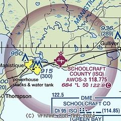
|
| Airport distance calculator |
|---|
|
|
| Sunrise and sunset |
|---|
|
Times for 23-May-2026
| | Local
(UTC-4) | | Zulu
(UTC) |
|---|
| Morning civil twilight | | 05:29 | | 09:29 |
| Sunrise | | 06:05 | | 10:05 |
| Sunset | | 21:18 | | 01:18 |
| Evening civil twilight | | 21:54 | | 01:54 |
|
| Current date and time |
|---|
| Zulu (UTC) | 23-May-2026 18:08:34 |
|---|
| Local (UTC-4) | 23-May-2026 14:08:34 |
|---|
|
| METAR |
|---|
| KISQ | 231755Z AUTO 08007KT 10SM SCT042 OVC048 14/05 A3010 RMK AO2 60003 T01430054 10147 20090
|
|
| NOTAMs |
|---|
NOTAMs are issued by the DoD/FAA and will open in a separate window not controlled by AirNav.
|
|

