FAA INFORMATION EFFECTIVE 25 DECEMBER 2025
Location
| FAA Identifier: | 37XA |
| Lat/Long: | 29-59-34.1981N 095-55-49.7350W
29-59.569968N 095-55.828917W
29.9928328,-95.9304819
(estimated) |
| Elevation: | 235 ft. / 71.6 m (surveyed) |
| Variation: | 06E (1985) |
| From city: | 4 miles S of WALLER, TX |
| Time zone: | UTC -6 (UTC -5 during Daylight Saving Time) |
| Zip code: | 77484 |
Airport Operations
| Airport use: | Private use. Permission required prior to landing |
| Activation date: | 03/1962 |
| Control tower: | no |
| ARTCC: | HOUSTON CENTER |
| FSS: | MONTGOMERY COUNTY FLIGHT SERVICE STATION |
| Attendance: | UNATNDD |
| Wind indicator: | yes |
| Segmented circle: | no |
| Lights: | ACTVT LIRL RY N/S - CTAF. CALL 832-607-5698 FOR AVAILABILITY. |
| Beacon: | white-green (lighted land airport)
ROTG BCN OTS INDEFLY. Operates sunset to sunrise. |
Airport Communications
| WX AWOS-3 at TME (11 nm S): | 119.525 (281-574-7296) |
Nearby radio navigation aids
| VOR radial/distance | | VOR name | | Freq | | Var |
|---|
| TNVr152/18.9 | | NAVASOTA VOR/DME | | 115.90 | | 08E |
| IAHr269/30.5 | | HUMBLE VORTAC | | 116.60 | | 05E |
Airport Services
| Parking: | tiedowns |
| Airframe service: | MINOR
FOR REPAIRS CALL 832-607-5698. |
| Powerplant service: | MINOR |
Runway Information
Runway 17/35
| Dimensions: | 4190 x 50 ft. / 1277 x 15 m |
| Surface: | asphalt/treated, in poor condition
SEVERELY GRASS ENCROACHED. |
| Operational restrictions: | RY CLSD INDEFLY. |
| RUNWAY 17 | | RUNWAY 35 |
| Latitude: | 29-59.950000N | | 29-59.258833N |
| Longitude: | 095-55.826000W | | 095-55.818333W |
| Elevation: | 230.0 ft. | | 226.0 ft. |
| Traffic pattern: | left | | left |
| Runway heading: | 174 magnetic, 180 true | | 354 magnetic, 360 true |
| Obstructions: | 50 ft. trees, 280 ft. from runway, 1:1 slope to clear
45 FT TREE 50 FT FM THLD 55 FT R. | | 30 ft. trees, 675 ft. from runway, 50 ft. right of centerline, 15:1 slope to clear
+32 FT PLINE 107 FT FM THLD ACRS APCH. |
Runway N/S
| Dimensions: | 3030 x 53 ft. / 924 x 16 m |
| Surface: | turf, in good condition |
| Runway edge lights: | low intensity
2590 FT OF RY AVBL FOR NIGHT OPNS; RY N THLD RELOCATED 440 FT AT NIGHT. |
| RUNWAY N | | RUNWAY S |
| Latitude: | 29-59.272333N | | 29-59.772333N |
| Longitude: | 095-55.835000W | | 095-55.841500W |
| Elevation: | 224.0 ft. | | 228.0 ft. |
| Traffic pattern: | left | | left |
| Obstructions: | 16 ft. brush, 54 ft. from runway, 36 ft. right of centerline, 3:1 slope to clear | | 55 ft. trees, 363 ft. from runway, 159 ft. right of centerline, 6:1 slope to clear |
Airport Ownership and Management from official FAA records
| Ownership: | Privately-owned |
| Owner: | RICHARD D. DAVIS LLP
15355 PENICK ROAD
WALLER, TX 77484
Phone 832-607-5698 |
| Manager: | KIM SUAREZ
15355 PENICK ROAD
WALLER, TX 77484
Phone 832-607-5698 |
Additional Remarks
| - | HIGH CONCENTRATION OF SKYDIVING ACTIVITY WITHIN A 3 NM RADIUS OF ARPT. |
| - | FOR CD CTC HOUSTON ARTCC AT 281-230-5622. |
Instrument Procedures
There are no published instrument procedures at 37XA.
Some nearby airports with instrument procedures:
KTME - Houston Executive Airport (11 nm S)
KIWS - West Houston Airport (17 nm SE)
KDWH - David Wayne Hooks Memorial Airport (20 nm E)
60R - Navasota Municipal Airport (24 nm NW)
KSGR - Sugar Land Regional Airport (26 nm SE)
|
|

Road maps at:
MapQuest
Bing
Google
| Aerial photo |
|---|
WARNING: Photo may not be current or correct

Do you have a better or more recent aerial photo of Skydive Houston Airport that you would like to share? If so, please send us your photo.
|
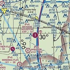
| Sectional chart |
|---|
|
| Airport distance calculator |
|---|
|
|
| Sunrise and sunset |
|---|
|
Times for 03-Jan-2026
| | Local
(UTC-6) | | Zulu
(UTC) |
|---|
| Morning civil twilight | | 06:55 | | 12:55 |
| Sunrise | | 07:21 | | 13:21 |
| Sunset | | 17:35 | | 23:35 |
| Evening civil twilight | | 18:02 | | 00:02 |
|
| Current date and time |
|---|
| Zulu (UTC) | 03-Jan-2026 10:20:48 |
|---|
| Local (UTC-6) | 03-Jan-2026 04:20:48 |
|---|
|
| METAR |
|---|
KTME
11nm S | 030955Z AUTO 24006KT 8SM 17/17 A2980 RMK AO2
|
KDWH
20nm E | 030953Z AUTO 22005KT 10SM CLR 18/16 A2977 RMK AO2 SLP078 T01780161
|
|
| NOTAMs |
|---|
NOTAMs are issued by the DoD/FAA and will open in a separate window not controlled by AirNav.
|
|

