FAA INFORMATION EFFECTIVE 16 APRIL 2026
Location
| FAA Identifier: | 3C1 |
| Lat/Long: | 41-39-25.1750N 086-02-05.0060W
41-39.419583N 086-02.083433W
41.6569931,-86.0347239
(estimated) |
| Elevation: | 755 ft. / 230 m (estimated) |
| Variation: | 03W (1985) |
| From city: | 3 miles SW of ELKHART, IN |
| Time zone: | UTC -4 (UTC -5 during Standard Time) |
| Zip code: | 46517 |
Airport Operations
| Airport use: | Open to the public |
| Activation date: | 08/1964 |
| Control tower: | no |
| ARTCC: | CHICAGO CENTER |
| FSS: | TERRE HAUTE FLIGHT SERVICE STATION |
| NOTAMs facility: | HUF (NOTAM-D service available) |
| Attendance: | IRREG |
| Wind indicator: | lighted |
| Segmented circle: | no |
| Lights: | SS-SR |
| Beacon: | white-green (lighted land airport)
OTS INDEFLY. DUSK-DAWN. |
Airport Communications
| CTAF: | 122.9 |
| WX AWOS-3PT at EKM (4 nm N): | 124.475 (574-264-9002) |
| WX ASOS at SBN (13 nm W): | 120.675 (574-200-0869) |
| WX ASOS at GSH (13 nm SE): | 121.45 (574-642-4231) |
Nearby radio navigation aids
| VOR radial/distance | | VOR name | | Freq | | Var |
|---|
| GIJr118/14.4 | | GIPPER VORTAC | | 115.40 | | 00E |
| OLKr319/(34.5) | | WEBSTER LAKE VOR | | 110.40 | | 03W |
| NDB name | | Hdg/Dist | | Freq | | Var | | ID |
|---|
| MISHA | | 114/8.8 | | 341 | | 05W | | SB | ... -... |
| STURGIS | | 255/28.5 | | 382 | | 04W | | IRS | .. .-. ... |
Airport Services
Runway Information
Runway 3/21
| Dimensions: | 2243 x 40 ft. / 684 x 12 m |
| Surface: | asphalt, in good condition |
| Runway edge lights: | low intensity |
| RUNWAY 3 | | RUNWAY 21 |
| Latitude: | 41-39.166667N | | 41-39.551500N |
| Longitude: | 086-02.200000W | | 086-01.949833W |
| Elevation: | 755.0 ft. | | 750.0 ft. |
| Traffic pattern: | left | | left |
| Displaced threshold: | 187 ft. | | 200 ft. |
| Markings: | basic, in fair condition | | basic, in fair condition |
| Runway end identifier lights: | no | | no |
| Obstructions: | 15 ft. road, 240 ft. from runway, 125 ft. right of centerline, 2:1 slope to clear
APCH SLOPE 28:1 FM DTHR. | | 15 ft. road, 240 ft. from runway, 130 ft. right of centerline, 2:1 slope to clear
APCH SLOPE 29:1 FM DTHR. |
Runway 12/30
| Dimensions: | 3140 x 100 ft. / 957 x 30 m |
| Surface: | turf, in excellent condition |
| Runway edge markings: | GND MKRS. |
| RUNWAY 12 | | RUNWAY 30 |
| Latitude: | 41-39.499500N | | 41-39.300000N |
| Longitude: | 086-02.320167W | | 086-01.850000W |
| Elevation: | 752.0 ft. | | 753.0 ft. |
| Traffic pattern: | left | | left |
| Displaced threshold: | 690 ft. | | 520 ft. |
| Markings: | NSTD | | NSTD |
| Runway end identifier lights: | no | | no |
| Obstructions: | 75 ft. trees, 255 ft. from runway, 130 ft. right of centerline, 3:1 slope to clear
APCH SLOPE 12:1 FM DTHR. | | 45 ft. trees, 180 ft. from runway, 120 ft. left of centerline, 4:1 slope to clear |
Airport Ownership and Management from official FAA records
| Ownership: | Privately-owned |
| Owner: | AIRPORT REALITY BOARD
29580 COUNTY ROAD 20
ELKHART, IN 46517
Phone (574) 522-9025 |
| Manager: | CHRIS RINGOS
29580 COUNTY ROAD 20
ELKHART, IN 46517
Phone (574) 675-7575 |
Additional Remarks
| - | FOR CD CTC SOUTH BEND APCH 574-251-2609. WHEN SOUTH BEND APCH CLSD, FOR CD CTC CHICAGO ARTCC AT 630-906-8921. |
Instrument Procedures
There are no published instrument procedures at 3C1.
Some nearby airports with instrument procedures:
KEKM - Elkhart Municipal Airport (4 nm N)
KSBN - South Bend International Airport (13 nm W)
KGSH - Goshen Municipal Airport (13 nm SE)
C03 - Nappanee Municipal Airport (13 nm S)
3TR - Jerry Tyler Memorial Airport (14 nm NW)
|
|

Road maps at:
MapQuest
Bing
Google
| Aerial photo |
|---|
WARNING: Photo may not be current or correct

Do you have a better or more recent aerial photo of Mishawaka Pilots Club Airport that you would like to share? If so, please send us your photo.
|
| Sectional chart |
|---|
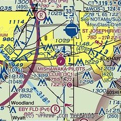
|
| Airport distance calculator |
|---|
|
|
| Sunrise and sunset |
|---|
|
Times for 01-May-2026
| | Local
(UTC-4) | | Zulu
(UTC) |
|---|
| Morning civil twilight | | 06:12 | | 10:12 |
| Sunrise | | 06:42 | | 10:42 |
| Sunset | | 20:41 | | 00:41 |
| Evening civil twilight | | 21:11 | | 01:11 |
|
| Current date and time |
|---|
| Zulu (UTC) | 01-May-2026 09:30:15 |
|---|
| Local (UTC-4) | 01-May-2026 05:30:15 |
|---|
|
| METAR |
|---|
KEKM
4nm NE | 010915Z AUTO 11004KT 9SM -RA FEW009 OVC024 03/03 A2994 RMK AO2 P0000 T00270027 $
|
KSBN
13nm W | 010854Z AUTO 10006KT 10SM -RA SCT008 OVC047 04/02 A2995 RMK AO2 SLP145 6//// T00390022 55008 PNO
|
KGSH
14nm SE | 010922Z AUTO 09008KT 7SM -RA SCT007 BKN027 OVC045 02/01 A2993 RMK AO2 P0005 T00220011
|
|
| TAF |
|---|
KSBN
13nm W | 010520Z 0106/0206 03005KT 6SM -SHRA OVC020 TEMPO 0107/0110 4SM -SHRA OVC009 FM011000 34004KT P6SM BKN025 FM011600 32012KT P6SM BKN040 FM020100 33006KT P6SM FEW250
|
|
| NOTAMs |
|---|
NOTAMs are issued by the DoD/FAA and will open in a separate window not controlled by AirNav.
|
|

