FAA INFORMATION EFFECTIVE 14 MAY 2026
Location
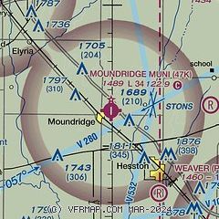
| FAA Identifier: | 47K |
| Lat/Long: | 38-12-32.7300N 097-30-09.8100W
38-12.545500N 097-30.163500W
38.2090917,-97.5027250
(estimated) |
| Elevation: | 1489 ft. / 453.8 m (surveyed) |
| Variation: | 07E (1985) |
| From city: | 1 mile E of MOUNDRIDGE, KS |
| Time zone: | UTC -5 (UTC -6 during Standard Time) |
| Zip code: | 67107 |
Airport Operations
| Airport use: | Open to the public |
| Activation date: | 08/1971 |
| Control tower: | no |
| ARTCC: | KANSAS CITY CENTER |
| FSS: | WICHITA FLIGHT SERVICE STATION |
| NOTAMs facility: | ICT (NOTAM-D service available) |
| Attendance: | MON - FRI 0800-1700 |
| Wind indicator: | yes |
| Segmented circle: | no |
| Beacon: | white-green (lighted land airport)
Operates sunset to sunrise. |
Airport Communications
| CTAF: | 122.9 |
| WICHITA APPROACH: | 125.5 |
| WICHITA DEPARTURE: | 125.5 |
| WX AWOS-3P at MPR (12 nm NW): | 119.025 (620-798-1650) |
| WX AWOS-3PT at EWK (14 nm SE): | 123.875 (316-283-8789) |
| WX ASOS at HUT (19 nm SW): | PHONE 620-662-1071 |
Nearby radio navigation aids
| VOR radial/distance | | VOR name | | Freq | | Var |
|---|
| HUTr054/24.0 | | HUTCHINSON VOR/DME | | 116.80 | | 04E |
| ICTr001/28.1 | | WICHITA VORTAC | | 113.80 | | 07E |
| NDB name | | Hdg/Dist | | Freq | | Var | | ID |
|---|
| HARVS | | 284/11.4 | | 395 | | 06E | | CA | -.-. .- |
Airport Services
| Fuel available: | 100LL MOGAS
100LL:FUEL 24 HR SELF SERVE. |
| Parking: | hangars and tiedowns |
| Airframe service: | NONE |
| Powerplant service: | NONE |
Runway Information
Runway 17/35
| Dimensions: | 3405 x 50 ft. / 1038 x 15 m |
| Surface: | asphalt, in good condition |
| Runway edge lights: | low intensity |
| RUNWAY 17 | | RUNWAY 35 |
| Latitude: | 38-12.826000N | | 38-12.265000N |
| Longitude: | 097-30.163000W | | 097-30.164000W |
| Elevation: | 1489.0 ft. | | 1487.8 ft. |
| Traffic pattern: | left | | left |
| Runway heading: | 173 magnetic, 180 true | | 353 magnetic, 000 true |
| Markings: | nonprecision, in fair condition | | nonprecision, in fair condition |
| Touchdown point: | yes, no lights | | yes, no lights |
| Obstructions: | 25 ft. trees, 925 ft. from runway, 82 ft. left of centerline, 29:1 slope to clear
20 FT BLDG, 0-199 FT DSTC, 204 FT R. 55 FT RTG BCN, 67 FT DSTC, 214 FT L. | | 20 ft. bldg, lighted, 201 ft. from runway, 173 ft. both sides of centerline |
Airport Ownership and Management from official FAA records
| Ownership: | Publicly-owned |
| Owner: | CITY OF MOUNDRIDGE
225 SOUTH CHRISTIAN AVENUE
MOUNDRIDGE, KS 67107
Phone 620-345-8246
AMGR CELL. |
| Manager: | MIKE STRAUSZ
225 SOUTH CHRISTIAN AVENUE
MOUNDRIDGE, KS 67107
Phone 620-345-1281 |
Additional Remarks
| - | FOR CD CTC WICHITA APCH AT 316-350-1520. |
Instrument Procedures
NOTE: All procedures below are presented as PDF files. If you need a reader for these files, you should download the free Adobe Reader.NOT FOR NAVIGATION. Please procure official charts for flight.
FAA instrument procedures published for use from 14 May 2026 at 0901Z to 11 June 2026 at 0900Z.
IAPs - Instrument Approach Procedures |
|---|
| RNAV (GPS) RWY 17 | |
download (165KB) |
| RNAV (GPS) RWY 35 | |
download (167KB) |
| NOTE: Special Take-Off Minimums/Departure Procedures apply | |
download (147KB) |
Other nearby airports with instrument procedures:
KMPR - Mc Pherson Airport (12 nm NW)
KEWK - Newton City/County Airport (14 nm SE)
KHUT - Hutchinson Regional Airport (19 nm SW)
KAAO - Colonel James Jabara Airport (31 nm SE)
1K1 - Lloyd Stearman Field Airport (32 nm SE)
|
|

Road maps at:
MapQuest
Bing
Google
| Aerial photo |
|---|
WARNING: Photo may not be current or correct
 Photo taken 31-Dec-2005
Do you have a better or more recent aerial photo of Moundridge Municipal Airport that you would like to share? If so, please send us your photo.
|
| Sectional chart |
|---|
|
| Airport distance calculator |
|---|
|
|
| Sunrise and sunset |
|---|
|
Times for 05-Jun-2026
| | Local
(UTC-5) | | Zulu
(UTC) |
|---|
| Morning civil twilight | | 05:37 | | 10:37 |
| Sunrise | | 06:08 | | 11:08 |
| Sunset | | 20:49 | | 01:49 |
| Evening civil twilight | | 21:20 | | 02:20 |
|
| Current date and time |
|---|
| Zulu (UTC) | 06-Jun-2026 01:58:34 |
|---|
| Local (UTC-5) | 05-Jun-2026 20:58:34 |
|---|
|
| METAR |
|---|
KMPR
12nm NW | 060135Z AUTO 18013KT 10SM SCT028 27/22 A2984 RMK AO2 T02700218
|
KEWK
15nm SE | 060056Z AUTO 17013KT 10SM CLR 27/22 A2987 RMK AO2 SLP100 T02670222 $
|
KHUT
19nm SW | 060152Z 16009KT 10SM CLR 26/22 A2984 RMK AO2 SLP083 T02560217
|
|
| TAF |
|---|
KHUT
19nm SW | 051720Z 0518/0618 20014G22KT P6SM SCT200 FM060000 17011KT P6SM BKN200 FM061700 18012KT P6SM BKN100
|
|
| NOTAMs |
|---|
NOTAMs are issued by the DoD/FAA and will open in a separate window not controlled by AirNav.
|
|

