FAA INFORMATION EFFECTIVE 14 MAY 2026
Location
| FAA Identifier: | 4G7 |
| Lat/Long: | 39-26-51.1466N 080-10-03.4849W
39-26.852443N 080-10.058082W
39.4475407,-80.1676347
(estimated) |
| Elevation: | 1032.4 ft. / 314.7 m (surveyed) |
| Variation: | 09W (2010) |
| From city: | 2 miles SW of FAIRMONT, WV |
| Time zone: | UTC -4 (UTC -5 during Standard Time) |
| Zip code: | 26554 |
Airport Operations
| Airport use: | Open to the public |
| Activation date: | 09/1970 |
| Control tower: | no |
| ARTCC: | CLEVELAND CENTER |
| FSS: | ELKINS FLIGHT SERVICE STATION [703-724-4288] |
| NOTAMs facility: | EKN (NOTAM-D service available) |
| Attendance: | MON-FRI 0830-1430 |
| Wind indicator: | lighted |
| Segmented circle: | no |
| Lights: | ACTVT REIL RWY 23; MIRL RWY 5/23 - CTAF. |
| Beacon: | white-green (lighted land airport)
Operates sunset to sunrise. |
Airport Communications
| CTAF/UNICOM: | 122.8 |
| CLARKSBURG APPROACH: | 121.15 [0700-2300] |
| CLARKSBURG DEPARTURE: | 121.15 [0700-2300] |
| CLEARANCE DELIVERY: | 118.35 |
| WX ASOS at CKB (9 nm S): | PHONE 304-842-9240 |
| WX ASOS at MGW (17 nm NE): | 120.675 (304-371-2021) |
- APCH/DEP SVC PRVDD BY CLEVELAND ARTCC (ZOB) ON FREQS 126.95/239.3 (BELMONT RCAG) WHEN CLARKSBURG APCH CTL CLSD.
Nearby radio navigation aids
| VOR radial/distance | | VOR name | | Freq | | Var |
|---|
| CKBr026/12.6 | | CLARKSBURG VOR/DME | | 112.60 | | 04W |
| MGWr250/15.7 | | MORGANTOWN VOR/DME | | 111.60 | | 05W |
| EKNr001/32.1 | | ELKINS VORTAC | | 114.20 | | 07W |
| NDB name | | Hdg/Dist | | Freq | | Var | | ID |
|---|
| RANDOLPH COUNTY | | 344/36.2 | | 284 | | 07W | | RQY | .-. --.- -.-- |
Airport Services
| Fuel available: | 100LL |
| Parking: | tiedowns |
| Airframe service: | MAJOR |
| Powerplant service: | MAJOR |
| Bottled oxygen: | NONE |
| Bulk oxygen: | NONE |
Runway Information
Runway 5/23
| Dimensions: | 2965 x 75 ft. / 904 x 23 m |
| Surface: | asphalt, in good condition |
| Weight bearing capacity: | |
| Runway edge lights: | medium intensity |
| RUNWAY 5 | | RUNWAY 23 |
| Latitude: | 39-26.658300N | | 39-27.046587N |
| Longitude: | 080-10.249020W | | 080-09.867142W |
| Elevation: | 1032.4 ft. | | 1012.6 ft. |
| Traffic pattern: | left | | left |
| Runway heading: | 046 magnetic, 037 true | | 226 magnetic, 217 true |
| Displaced threshold: | 720 ft. | | no |
| Markings: | basic, in fair condition | | nonprecision, in fair condition |
| Runway end identifier lights: | | | yes |
| Touchdown point: | yes, no lights | | yes, no lights |
| Obstructions: | 30 ft. gnd, 201 ft. from runway, 73 ft. left of centerline
+30 FT HILL 201 FT FM THLD 0B. | | 30 ft. trees, 201 ft. from runway, 240 ft. right of centerline
12 FT TREES, 199 FT DSTC, 235 R. |
Airport Ownership and Management from official FAA records
| Ownership: | Publicly-owned |
| Owner: | FAIRMONT-MARION CO REG ARPT AUTH
P.O. BOX 387
FAIRMONT, WV 26555-0387
Phone 304-282-5289 |
| Manager: | DONNIE TUCKER
PO BOX 387
FAIRMONT, WV 26555
Phone 304-366-1300
304-612-4015 MGR CELL |
Additional Remarks
| - | RADIO TOWERS APRX 300' AGL 2 MILES NE AND 2.5 MILES NW OF ARPT. |
| - | DEER ON & INVOF ARPT. |
| - | RWY 23 HAS 100 FT DROP OFF, NE END. |
| - | RWY 5 HAS +30 FT HILL AT SW END. |
| - | FOR CD CTC CLARKSBURG APCH AT 304-842-2011, WHEN APCH CLSD CTC CLEVELAND ARTCC AT 440-774-0226. |
| - | AFTR HRS ATNDT 304-933-4399 - CALL IN FEE. |
Instrument Procedures
NOTE: All procedures below are presented as PDF files. If you need a reader for these files, you should download the free Adobe Reader.NOT FOR NAVIGATION. Please procure official charts for flight.
FAA instrument procedures published for use from 14 May 2026 at 0901Z to 11 June 2026 at 0900Z.
IAPs - Instrument Approach Procedures |
|---|
| RNAV (GPS) RWY 23 | |
download (188KB) |
| NOTE: Special Take-Off Minimums/Departure Procedures apply | |
download (428KB) |
Other nearby airports with instrument procedures:
KCKB - North Central West Virginia Airport (9 nm S)
KMGW - Morgantown Municipal Airport/Walter L Bill Hart Field (16 nm NE)
79D - Philippi/Barbour County Regional Airport (18 nm S)
KWAY - Greene County Airport (27 nm N)
W22 - Upshur County Regional Airport (27 nm S)
|
|

Road maps at:
MapQuest
Bing
Google
| Aerial photo |
|---|
WARNING: Photo may not be current or correct
 Photo taken 13-Jun-2006
Do you have a better or more recent aerial photo of Fairmont Municipal Airport-Frankman Field that you would like to share? If so, please send us your photo.
|
| Sectional chart |
|---|
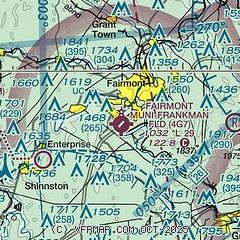
|
| Airport distance calculator |
|---|
|
|
| Sunrise and sunset |
|---|
|
Times for 08-Jun-2026
| | Local
(UTC-4) | | Zulu
(UTC) |
|---|
| Morning civil twilight | | 05:22 | | 09:22 |
| Sunrise | | 05:54 | | 09:54 |
| Sunset | | 20:45 | | 00:45 |
| Evening civil twilight | | 21:17 | | 01:17 |
|
| Current date and time |
|---|
| Zulu (UTC) | 08-Jun-2026 18:32:15 |
|---|
| Local (UTC-4) | 08-Jun-2026 14:32:15 |
|---|
|
| METAR |
|---|
KCKB
9nm S | 081753Z 11003KT 10SM BKN050 28/17 A3014 RMK AO2 SLP192 T02830172 10294 20189 58006
|
KMGW
17nm NE | 081753Z 14006KT 10SM FEW060 29/14 A3017 RMK AO2 SLP206 T02940144 10294 20206 58005
|
|
| TAF |
|---|
KCKB
9nm S | 081720Z 0818/0918 VRB03KT P6SM SCT040 FM090400 00000KT P6SM BKN090 FM091200 VRB03KT P6SM BKN070 FM091700 20008G15KT P6SM BKN045
|
KMGW
17nm NE | 081720Z 0818/0918 13005KT P6SM BKN250 FM091600 17006KT P6SM SCT040 BKN070
|
|
| NOTAMs |
|---|
NOTAMs are issued by the DoD/FAA and will open in a separate window not controlled by AirNav.
|
|

