FAA INFORMATION EFFECTIVE 19 FEBRUARY 2026
Location
| FAA Identifier: | 4J1 |
| Lat/Long: | 31-12-21.8480N 081-54-21.5500W
31-12.364133N 081-54.359167W
31.2060689,-81.9059861
(estimated) |
| Elevation: | 84.7 ft. / 25.8 m (surveyed) |
| Variation: | 06W (2010) |
| From city: | 4 miles E of NAHUNTA, GA |
| Time zone: | UTC -5 (UTC -4 during Daylight Saving Time) |
| Zip code: | 31553 |
Airport Operations
| Airport use: | Open to the public |
| Control tower: | no |
| ARTCC: | JACKSONVILLE CENTER |
| FSS: | MACON FLIGHT SERVICE STATION |
| NOTAMs facility: | MCN (NOTAM-D service available) |
| Attendance: | UNATNDD |
| Wind indicator: | lighted |
| Segmented circle: | yes |
| Lights: | ACTVT PAPI RWY 01 & 19; MIRL RWY 01/19 - CTAF. |
| Beacon: | white-green (lighted land airport)
Operates sunset to sunrise. |
Airport Communications
- APCH/DEP SVC PRVDD BY JACKSONVILLE ARTCC ON FREQS 127.575/269.025 (ALMA RCAG).
Nearby radio navigation aids
| VOR radial/distance | | VOR name | | Freq | | Var |
|---|
| SSIr296/25.4 | | BRUNSWICK VORTAC | | 109.80 | | 04W |
| AYSr096/33.6 | | WAYCROSS VORTAC | | 112.40 | | 00E |
Airport Services
| Parking: | tiedowns |
| Airframe service: | NONE |
| Powerplant service: | NONE |
| Bottled oxygen: | NONE |
| Bulk oxygen: | NONE |
Runway Information
Runway 1/19
| Dimensions: | 4000 x 75 ft. / 1219 x 23 m |
| Surface: | asphalt, in good condition |
| Weight bearing capacity: | |
| Runway edge lights: | medium intensity |
| RUNWAY 1 | | RUNWAY 19 |
| Latitude: | 31-12.036262N | | 31-12.692010N |
| Longitude: | 081-54.401180W | | 081-54.317158W |
| Elevation: | 80.5 ft. | | 80.7 ft. |
| Traffic pattern: | left | | left |
| Runway heading: | 012 magnetic, 006 true | | 192 magnetic, 186 true |
| Displaced threshold: | no | | 700 ft. |
| Markings: | nonprecision, in good condition | | nonprecision, in good condition |
| Visual slope indicator: | 2-light PAPI on left (3.00 degrees glide path) | | 2-light PAPI on left (3.00 degrees glide path) |
| Touchdown point: | yes, no lights | | yes, no lights |
| Obstructions: | 20 ft. trees, 201 ft. from runway, 240 ft. right of centerline | | 86 ft. trees, 1060 ft. from runway, 355 ft. right of centerline, 10:1 slope to clear |
Airport Ownership and Management from official FAA records
| Ownership: | Publicly-owned |
| Owner: | BRANTLEY COUNTY
33 ALLEN RD, PO BOX 398, 117 BRANTLY STREET
NAHUNTA, GA 31553
Phone 912-462-5256 |
| Manager: | JOEY CASON
33 ALLEN RD, PO BOX 792
NAHUNTA, GA 31553
Phone (912) 462-5256 |
Additional Remarks
| - | FOR CD CTC JACKSONVILLE ARTCC AT 904-845-1592. |
Instrument Procedures
NOTE: All procedures below are presented as PDF files. If you need a reader for these files, you should download the free Adobe Reader.NOT FOR NAVIGATION. Please procure official charts for flight.
FAA instrument procedures published for use from 19 February 2026 at 0901Z to 19 March 2026 at 0900Z.
IAPs - Instrument Approach Procedures |
|---|
| RNAV (GPS) RWY 01 | |
download (232KB) |
| RNAV (GPS) RWY 19 | |
download (221KB) |
| NOTE: Special Take-Off Minimums/Departure Procedures apply | |
download (189KB) |
Other nearby airports with instrument procedures:
KJES - Jesup-Wayne County Airport (21 nm N)
KBQK - Brunswick Golden Isles Airport (23 nm E)
KAYS - Waycross-Ware County Airport (25 nm W)
09J - Jekyll Island Airport (26 nm E)
KSSI - St Simons Island Airport (27 nm E)
|
|

Road maps at:
MapQuest
Bing
Google
| Aerial photo |
|---|
WARNING: Photo may not be current or correct
 Photo taken 24-Sep-2011
looking south-southwest.
Photo taken 24-Sep-2011
looking south-southwest.
Do you have a better or more recent aerial photo of Brantley County Airport that you would like to share? If so, please send us your photo.
|
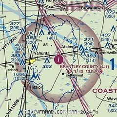
| Sectional chart |
|---|
|
| Airport distance calculator |
|---|
|
|
| Sunrise and sunset |
|---|
|
Times for 17-Mar-2026
| | Local
(UTC-4) | | Zulu
(UTC) |
|---|
| Morning civil twilight | | 07:12 | | 11:12 |
| Sunrise | | 07:36 | | 11:36 |
| Sunset | | 19:36 | | 23:36 |
| Evening civil twilight | | 20:00 | | 00:00 |
|
| Current date and time |
|---|
| Zulu (UTC) | 17-Mar-2026 21:17:49 |
|---|
| Local (UTC-4) | 17-Mar-2026 17:17:49 |
|---|
|
| METAR |
|---|
KJES
21nm N | 172055Z AUTO 29006G09KT 10SM CLR 12/M05 A3016 RMK AO2
|
KBQK
23nm E | 172055Z AUTO 28009KT 10SM CLR 12/M05 A3013 RMK AO2 T01231054
|
KAYS
25nm W | 172055Z AUTO 33009KT 10SM CLR 12/M07 A3015 RMK AO2 T01231070
|
KSSI
27nm E | 172055Z AUTO 30009G14KT 10SM CLR 13/M05 A3012 RMK AO2
|
|
| TAF |
|---|
KSSI
27nm E | 171735Z 1718/1818 31010G15KT P6SM SCT150 BKN250 FM180000 33005KT P6SM SCT150 BKN250 FM181300 02009KT P6SM SCT250
|
|
| NOTAMs |
|---|
NOTAMs are issued by the DoD/FAA and will open in a separate window not controlled by AirNav.
|
|


