FAA INFORMATION EFFECTIVE 16 APRIL 2026
Location
| FAA Identifier: | JES |
| Lat/Long: | 31-33-14.2680N 081-52-57.0640W
31-33.237800N 081-52.951067W
31.5539633,-81.8825178
(estimated) |
| Elevation: | 107.5 ft. / 32.8 m (surveyed) |
| Variation: | 04W (1990) |
| From city: | 3 miles S of JESUP, GA |
| Time zone: | UTC -4 (UTC -5 during Standard Time) |
| Zip code: | 31546 |
Airport Operations
| Airport use: | Open to the public |
| Control tower: | no |
| ARTCC: | JACKSONVILLE CENTER |
| FSS: | MACON FLIGHT SERVICE STATION |
| NOTAMs facility: | MCN (NOTAM-D service available) |
| Attendance: | MON-FRI 0800-1700 |
| Wind indicator: | lighted |
| Segmented circle: | yes |
| Lights: | ACTVT MIRL RY 11/29; PAPI RY 11; PAPI RY 29 & MALSF RY 29 - CTAF. |
| Beacon: | white-green (lighted land airport)
Operates sunset to sunrise. |
Airport Communications
| CTAF/UNICOM: | 122.8 |
| WX AWOS-3PT: | 118.125 (912-427-0855) |
- APCH/DEP SVC PRVDD BY JACKSONVILLE ARTCC (ZJX) ON FREQS 126.75/277.4 (BRUNSWICK RCAG).
Nearby radio navigation aids
| VOR radial/distance | | VOR name | | Freq | | Var |
|---|
| SSIr327/37.6 | | BRUNSWICK VORTAC | | 109.80 | | 04W |
| AYSr064/38.5 | | WAYCROSS VORTAC | | 112.40 | | 00E |
Airport Services
| Fuel available: | 100LL JET-A+ |
| Parking: | tiedowns |
| Airframe service: | MAJOR |
| Powerplant service: | MAJOR |
| Bottled oxygen: | NONE |
| Bulk oxygen: | NONE |
Runway Information
Runway 11/29
| Dimensions: | 5500 x 100 ft. / 1676 x 30 m |
| Surface: | asphalt, in good condition |
| Weight bearing capacity: | |
| Runway edge lights: | medium intensity |
| RUNWAY 11 | | RUNWAY 29 |
| Latitude: | 31-33.312488N | | 31-33.163092N |
| Longitude: | 081-53.473507W | | 081-52.428628W |
| Elevation: | 107.3 ft. | | 69.7 ft. |
| Traffic pattern: | left | | left |
| Runway heading: | 103 magnetic, 099 true | | 283 magnetic, 279 true |
| Markings: | nonprecision, in fair condition | | nonprecision, in fair condition |
| Visual slope indicator: | 2-light PAPI on left (3.75 degrees glide path) | | 2-light PAPI on left (3.00 degrees glide path) |
| Approach lights: | | | MALSF: 1,400 foot medium intensity approach lighting system with sequenced flashers |
| Touchdown point: | yes, no lights | | yes, no lights |
| Obstructions: | 99 ft. trees, 1883 ft. from runway, 73 ft. left of centerline, 17:1 slope to clear | | 30 ft. trees, 1070 ft. from runway, 369 ft. right of centerline, 29:1 slope to clear |
Airport Ownership and Management from official FAA records
| Ownership: | Publicly-owned |
| Owner: | WAYNE COUNTY
PO BOX 270
JESUP, GA 31598
Phone 912-427-5900 |
| Manager: | MITCH SUTTON
535 AIRPORT ROAD
JESUP, GA 31546
Phone 912-266-2234
ARPT PHONE 912-427-5949. |
Additional Remarks
| - | FOR CD CTC JACKSONVILLE ARTCC AT 904-845-1592. |
Instrument Procedures
NOTE: All procedures below are presented as PDF files. If you need a reader for these files, you should download the free Adobe Reader.NOT FOR NAVIGATION. Please procure official charts for flight.
FAA instrument procedures published for use from 16 April 2026 at 0901Z to 14 May 2026 at 0900Z.
IAPs - Instrument Approach Procedures |
|---|
| RNAV (GPS) RWY 11 | |
download (275KB) |
| RNAV (GPS) RWY 29 | |
download (295KB) |
| NOTE: Special Alternate Minimums apply | |
download (69KB) |
| NOTE: Special Take-Off Minimums/Departure Procedures apply | |
download (189KB) |
Other nearby airports with instrument procedures:
4J1 - Brantley County Airport (21 nm S)
KLHW - Wright Army Airfield (Fort Stewart)/Midcoast Regional Airport (26 nm NE)
KBQK - Brunswick Golden Isles Airport (28 nm SE)
KBHC - Baxley Municipal Airport (28 nm W)
KAMG - Bacon County Airport (32 nm W)
|
|

Road maps at:
MapQuest
Bing
Google
| Aerial photo |
|---|
WARNING: Photo may not be current or correct
 Photo taken 07-Jul-2013
looking west.
Photo taken 07-Jul-2013
looking west.
Do you have a better or more recent aerial photo of Jesup-Wayne County Airport that you would like to share? If so, please send us your photo.
|
| Sectional chart |
|---|
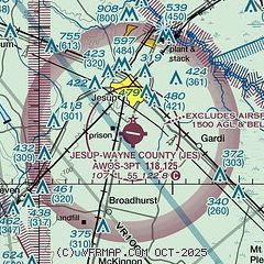
|
| Airport distance calculator |
|---|
|
|
| Sunrise and sunset |
|---|
|
Times for 07-May-2026
| | Local
(UTC-4) | | Zulu
(UTC) |
|---|
| Morning civil twilight | | 06:12 | | 10:12 |
| Sunrise | | 06:38 | | 10:38 |
| Sunset | | 20:10 | | 00:10 |
| Evening civil twilight | | 20:36 | | 00:36 |
|
| Current date and time |
|---|
| Zulu (UTC) | 07-May-2026 15:06:05 |
|---|
| Local (UTC-4) | 07-May-2026 11:06:05 |
|---|
|
| METAR |
|---|
| KJES | 071430Z AUTO 25005KT 10SM SCT110 23/18 A3001 RMK AO2
|
|
| TAF |
|---|
KSSI
35nm SE | 071337Z 0714/0812 23009KT 3SM HZ BR SCT020 FM071500 23010G15KT P6SM FEW040 FM071700 26013G22KT P6SM SCT040 BKN250 PROB30 0719/0722 VRB25G35KT 3SM +TSRA BR BKN035CB FM080100 25007KT P6SM BKN050
|
|
| NOTAMs |
|---|
NOTAMs are issued by the DoD/FAA and will open in a separate window not controlled by AirNav.
|
|


