FAA INFORMATION EFFECTIVE 19 MARCH 2026
Location
| FAA Identifier: | 52I |
| Lat/Long: | 43-50-48.6200N 084-00-46.0600W
43-50.810333N 084-00.767667W
43.8468389,-84.0127944
(estimated) |
| Elevation: | 618 ft. / 188 m (estimated) |
| Variation: | 06W (1985) |
| From city: | 3 miles W of PINCONNING, MI |
| Time zone: | UTC -4 (UTC -5 during Standard Time) |
| Zip code: | 48650 |
Airport Operations
| Airport use: | Open to the public |
| Activation date: | 11/1999 |
| Control tower: | no |
| ARTCC: | CLEVELAND CENTER |
| FSS: | LANSING FLIGHT SERVICE STATION |
| NOTAMs facility: | LAN (NOTAM-D service available) |
| Attendance: | IREG
FOR SVC CALL 989-239-9878. |
| Wind indicator: | yes |
| Segmented circle: | no |
| Lights: | ACTVT LIRL RWY 09/27 - CTAF. |
Airport Communications
| CTAF: | 122.9 |
| WX AWOS-3P at IKW (15 nm SW): | 119.525 (989-835-5841) |
| WX ASOS at MBS (19 nm S): | PHONE 989-695-2488 |
Nearby radio navigation aids
| VOR radial/distance | | VOR name | | Freq | | Var |
|---|
| MBSr011/19.1 | | SAGINAW VOR/DME | | 114.35 | | 03W |
| MOPr072/34.2 | | MOUNT PLEASANT VOR/DME | | 110.60 | | 05W |
Airport Services
| Fuel available: | 100LL
100LL:FUEL AVBL FOR LCL CLUB PILOTS OR EMERG USE ONLY. |
| Parking: | tiedowns |
| Airframe service: | NONE |
| Powerplant service: | NONE |
| Bottled oxygen: | NONE |
| Bulk oxygen: | NONE |
Runway Information
Runway 9/27
| Dimensions: | 3300 x 90 ft. / 1006 x 27 m |
| Surface: | turf, in good condition |
| Runway edge lights: | low intensity |
| Runway edge markings: | RWY & DTHR MKD WITH 3 FT YELLOW CONES. |
| RUNWAY 9 | | RUNWAY 27 |
| Latitude: | 43-50.815000N | | 43-50.805667N |
| Longitude: | 084-01.143000W | | 084-00.392500W |
| Elevation: | 618.0 ft. | | 611.0 ft. |
| Traffic pattern: | left | | left |
| Runway heading: | 097 magnetic, 091 true | | 277 magnetic, 271 true |
| Displaced threshold: | 765 ft. | | 442 ft. |
| Obstructions: | 60 ft. trees, 588 ft. from runway, 10 ft. left of centerline, 9:1 slope to clear
APCH RATIO 20:1 TO DTHR. | | 45 ft. tree, 10 ft. from runway, 118 ft. right of centerline, 1:1 slope to clear
APCH RATIO 10:1 TO DTHR OVR +45 FT TREE, 477 FT DIST, 118 FT R. |
Airport Ownership and Management from official FAA records
| Ownership: | Privately-owned |
| Owner: | CARL A GROSS, INC
706 5TH ST, BOX 31
PINCONNING, MI 48650-8730 |
| Manager: | JAMES M KLEIN
706 5TH ST, BOX 31
PINCONNING, MI 48650-8730
Phone 989-708-7583
ASST AMGR 989-239-9878. |
Additional Remarks
| - | FOR FICONS CALL 989-239-9878. |
| - | BLDGS IN PRI SFC EAST END, 70 FT NORTH & 93 FT SOUTH OF CNTRLN; 15-45 FT TREES, 95 FT SOUTH OF CNTRLN WEST END. |
| - | -6 FT DITCH, 5 FT WEST OF RWY END 09. |
| - | ULTRALIGHTS USE 500 FT TPA. |
| - | FOR CD CTC GREAT LAKES APCH AT 269-459-3345, WHEN APCH CLSD CTC CLEVELAND ARTCC AT 440-774-0224/0490. |
| - | DEER & LRG BIRDS ON & INVOF ARPT. |
Instrument Procedures
There are no published instrument procedures at 52I.
Some nearby airports with instrument procedures:
KIKW - Jack Barstow Airport (15 nm SW)
3CM - James Clements Municipal Airport (19 nm S)
KMBS - MBS International Airport (19 nm S)
KGDW - Gladwin Zettel Memorial Airport (21 nm W)
Y31 - West Branch Community Airport (25 nm N)
|
|

Road maps at:
MapQuest
Bing
Google
| Aerial photo |
|---|
WARNING: Photo may not be current or correct
 Photo by: Tom Taylor, Essexville, MI
Do you have a better or more recent aerial photo of Gross Airport that you would like to share? If so, please send us your photo.
|
| Sectional chart |
|---|
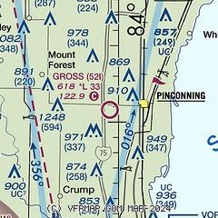
|
| Airport distance calculator |
|---|
|
|
| Sunrise and sunset |
|---|
|
Times for 13-Apr-2026
| | Local
(UTC-4) | | Zulu
(UTC) |
|---|
| Morning civil twilight | | 06:28 | | 10:28 |
| Sunrise | | 06:57 | | 10:57 |
| Sunset | | 20:16 | | 00:16 |
| Evening civil twilight | | 20:46 | | 00:46 |
|
| Current date and time |
|---|
| Zulu (UTC) | 13-Apr-2026 18:22:01 |
|---|
| Local (UTC-4) | 13-Apr-2026 14:22:01 |
|---|
|
| METAR |
|---|
KIKW
15nm SW | 131755Z AUTO 27011G17KT 10SM BKN029 BKN034 OVC047 23/15 A2988 RMK AO2 10233 20160
|
KMBS
19nm S | 131753Z 27013G22KT 10SM FEW028 SCT036 BKN044 22/16 A2989 RMK AO2 SLP118 T02170156 10222 20156 50006
|
KGDW
21nm W | 131755Z AUTO 26015KT 10SM SCT020 OVC031 21/15 A2987 RMK AO2 10208 20148
|
KY31
25nm N | 131755Z AUTO 25012G17KT 10SM SCT021 BKN028 OVC035 21/15 A2985 RMK AO2 T02130145 10215 20141
|
KHYX
26nm S | 131755Z AUTO 24012G19KT 10SM BKN030 BKN037 24/16 A2988 RMK AO2 10239 20160
|
|
| TAF |
|---|
KMBS
19nm S | 131739Z 1318/1418 26015G25KT P6SM BKN035 FM132100 20008KT P6SM SCT040 BKN150 FM140100 20008KT 5SM -SHRA OVC035 PROB30 1401/1405 2SM TSRA OVC030CB FM140800 22014KT 5SM -SHRA BKN028 OVC045 PROB30 1408/1410 4SM -TSRA BKN020 OVC040CB FM141200 24016G26KT P6SM BKN030
|
|
| NOTAMs |
|---|
NOTAMs are issued by the DoD/FAA and will open in a separate window not controlled by AirNav.
|
|

