FAA INFORMATION EFFECTIVE 19 MARCH 2026
Location
| FAA Identifier: | 74P |
| Lat/Long: | 36-16-19.4133N 115-59-42.9335W
36-16.323555N 115-59.715558W
36.2720592,-115.9952593
(estimated) |
| Elevation: | 2726 ft. / 831 m (estimated) |
| Variation: | 14E (1985) |
| From city: | 5 miles N of PAHRUMP, NV |
| Time zone: | UTC -7 (UTC -8 during Standard Time) |
| Zip code: | 89048 |
Airport Operations
| Airport use: | Open to the public |
| Activation date: | 07/1987 |
| Control tower: | no |
| ARTCC: | LOS ANGELES CENTER |
| FSS: | RENO FLIGHT SERVICE STATION |
| NOTAMs facility: | RNO (NOTAM-D service not available) |
| Attendance: | UNATNDD |
| Wind indicator: | yes |
| Segmented circle: | no |
| Lights: | ACTVT LIRL RWY 15/33 - CTAF 5 CLICKS. |
Airport Communications
Airport Services
| Fuel available: | 100LL JET-A JET-A+ |
| Parking: | tiedowns |
| Airframe service: | NONE |
| Powerplant service: | NONE |
| Bottled oxygen: | NONE |
| Bulk oxygen: | NONE |
Runway Information
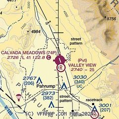
Runway 15/33
| Dimensions: | 4081 x 48 ft. / 1244 x 15 m |
| Surface: | asphalt/gravel/aggregate friction seal coat, in good condition |
| Runway edge lights: | low intensity |
| Runway edge markings: | RWY MARKINGS FADED. |
| RUNWAY 15 | | RUNWAY 33 |
| Latitude: | 36-16.646282N | | 36-16.000827N |
| Longitude: | 115-59.832447W | | 115-59.598668W |
| Elevation: | 2676.6 ft. | | 2717.5 ft. |
| Traffic pattern: | left | | left |
| Runway heading: | 150 magnetic, 164 true | | 330 magnetic, 344 true |
| Displaced threshold: | 200 ft. | | no |
| Markings: | basic, in fair condition | | basic, in fair condition |
| Runway end identifier lights: | no | | no |
| Touchdown point: | yes, no lights | | yes, no lights |
| Obstructions: | 35 ft. pline, 375 ft. from runway | | 12 ft. bldg, 400 ft. from runway |
Helipad H1
| Dimensions: | 20 x 20 ft. / 6 x 6 m |
| Surface: | concrete, in good condition |
| Latitude: | 36-16.652800N | | |
| Longitude: | 115-59.891427W | | |
| Elevation: | 2670.3 ft. | | |
| Traffic pattern: | left | | left |
Airport Ownership and Management from official FAA records
| Ownership: | Privately-owned |
| Owner: | CALVADA AIRPARK ASSOCIATION
900 E JENNY CIRCLE
PAHRUMP, NV 89060
Phone 888-540-0250 |
| Manager: | LEE PHILLIPS
900 E JENNY CIRCLE
PAHRUMP, NV 89060
Phone 760-608-2765 |
Additional Remarks
| - | FOR CD CTC LOS ANGELES ARTCC AT 661-575-2079. |
| - | HVY ACFT PRKG NW CORNER. |
| - | OTR CTC LEE PHILLIPS 760-603-7512. |
| - | TSNT ACFT PRKG OFF NW PARL TWY AT TRML. |
| - | PPR FOR ACFT OPRNS OVER 12500 LBS, COML OPRNS, AND FOR GLDR, PWRD PRCHT, BANNER TOWING, PRCHTG, FLT TRNG, UAS, OR JET OPRNS. |
| - | ACFT WINGSPANS EXCEEDING GROUP I (49 FT) RSTRD NW PARL TWY AND ALL TAXILANES. |
Instrument Procedures
There are no published instrument procedures at 74P.
Some nearby airports with instrument procedures:
KVGT - North Las Vegas Airport (39 nm E)
KLAS - Harry Reid International Airport (42 nm E)
KHND - Henderson Executive Airport (45 nm SE)
KLSV - Nellis Air Force Base (47 nm E)
KBVU - Boulder City Municipal Airport (58 nm E)
|
|

Road maps at:
MapQuest
Bing
Google
| Aerial photo |
|---|
WARNING: Photo may not be current or correct
 Photo by Leo Fitzgerald / Introflights.com
Taken in May 2021
looking north.
Photo by Leo Fitzgerald / Introflights.com
Taken in May 2021
looking north.
Do you have a better or more recent aerial photo of Calvada Meadows Airport that you would like to share? If so, please send us your photo.
|
| Sectional chart |
|---|
|
| Airport distance calculator |
|---|
|
|
| Sunrise and sunset |
|---|
|
Times for 26-Mar-2026
| | Local
(UTC-7) | | Zulu
(UTC) |
|---|
| Morning civil twilight | | 06:14 | | 13:14 |
| Sunrise | | 06:40 | | 13:40 |
| Sunset | | 19:00 | | 02:00 |
| Evening civil twilight | | 19:25 | | 02:25 |
|
| Current date and time |
|---|
| Zulu (UTC) | 26-Mar-2026 23:30:55 |
|---|
| Local (UTC-7) | 26-Mar-2026 16:30:55 |
|---|
|
| METAR |
|---|
KDRA
21nm N | 262253Z AUTO 24005KT 10SM CLR 31/M04 A2997 RMK AO2 SLP102 T03111044
|
KINS
25nm NE | 262155Z 32008KT 10SM CLR 32/M10 A2995 RMK AO2A SLP094 T03211100 $
|
KVGT
39nm E | 262253Z 10005KT 10SM CLR 33/M02 A2988 RMK AO2 SLP112 T03331017
|
|
| TAF |
|---|
KINS
25nm NE | 260455Z 2613/2719 VRB06KT 9999 SKC QNH2987INS BECMG 2617/2618 31012KT 9999 SKC QNH2986INS BECMG 2707/2708 02010KT 9999 SKC QNH3000INS TX32/2623Z TN13/2615Z
|
|
| NOTAMs |
|---|
NOTAMs are issued by the DoD/FAA and will open in a separate window not controlled by AirNav.
|
|


