FAA INFORMATION EFFECTIVE 14 MAY 2026
Location
| FAA Identifier: | 83D |
| Lat/Long: | 45-53-29.2000N 084-44-17.3000W
45-53.486667N 084-44.288333W
45.8914444,-84.7381389
(estimated) |
| Elevation: | 623.5 ft. / 190.0 m (surveyed) |
| Variation: | 06W (1990) |
| From city: | 2 miles NW of ST IGNACE, MI |
| Time zone: | UTC -4 (UTC -5 during Standard Time) |
| Zip code: | 49781 |
Airport Operations
| Airport use: | Open to the public |
| Activation date: | 04/1940 |
| Control tower: | no |
| ARTCC: | MINNEAPOLIS CENTER |
| FSS: | GREEN BAY FLIGHT SERVICE STATION |
| NOTAMs facility: | GRB (NOTAM-D service available) |
| Attendance: | DAWN-DUSK
FOR SVC AFT HRS CALL AMGR RES AT 906-643-7161. |
| Wind indicator: | yes |
| Segmented circle: | yes |
| Lights: | ACTVT REIL RWY 07 & 25; PAPI RWY 07 & 25; MIRL RWY 07/25; RAMP LGTS - CTAF. |
| Beacon: | white-green (lighted land airport)
Operates sunset to sunrise. |
Airport Communications
| CTAF/UNICOM: | 122.7 |
| WX AWOS-3P at MCD (5 nm E): | 118.275 (906-847-3778) |
| WX AWOS-3P at SLH (17 nm SE): | 118.175 (231-627-4671) |
| WX ASOS at PLN (19 nm S): | 119.025 (231-539-7700) |
- APCH/DEP SVC PRVDD BY MINNEAPOLIS ARTCC ON FREQS 134.6/354.05 (PELLSTON RCAG).
Nearby radio navigation aids
| VOR radial/distance | | VOR name | | Freq | | Var |
|---|
| PLNr355/16.0 | | PELLSTON VORTAC | | 111.80 | | 06W |
| SSMr213/35.9 | | SAULT STE MARIE VOR/DME | | 112.20 | | 04W |
Airport Services
| Fuel available: | 100LL JET-A+ |
| Parking: | hangars and tiedowns |
| Airframe service: | MAJOR |
| Powerplant service: | MAJOR |
| Bottled oxygen: | NONE |
| Bulk oxygen: | NONE |
Runway Information
Runway 7/25
| Dimensions: | 3800 x 75 ft. / 1158 x 23 m |
| Surface: | concrete, in good condition |
| Weight bearing capacity: | |
| Runway edge lights: | medium intensity |
| RUNWAY 7 | | RUNWAY 25 |
| Latitude: | 45-53.368452N | | 45-53.605187N |
| Longitude: | 084-44.702515W | | 084-43.873855W |
| Elevation: | 622.4 ft. | | 608.3 ft. |
| Traffic pattern: | left | | left |
| Runway heading: | 074 magnetic, 068 true | | 254 magnetic, 248 true |
| Markings: | nonprecision, in good condition | | nonprecision, in good condition |
| Visual slope indicator: | 4-light PAPI on left (4.00 degrees glide path) | | 4-light PAPI on left (3.00 degrees glide path) |
| Runway end identifier lights: | yes | | yes |
| Touchdown point: | yes, no lights | | yes, no lights |
| Obstructions: | 14 ft. brush, 387 ft. from runway, 209 ft. right of centerline, 13:1 slope to clear
5-10 FT BRUSH, 150-199 FT DIST, 240 FT L. | | none |
Airport Ownership and Management from official FAA records
| Ownership: | Publicly-owned |
| Owner: | MACKINAC CO BOARD OF COMMISSIONERS
COURT HOUSE, 110 S MARLEY ST
SAINT IGNACE, MI 49781-1518
Phone 906-643-7300 |
| Manager: | PAUL S FULLERTON
1220 N STATE ST
SAINT IGNACE, MI 49781-1014
Phone 906-643-7327 |
Additional Remarks
| - | DEER, BIRDS, & WILDLIFE ON & INVOF ARPT. |
| - | MCD AWOS FREQ CAN BE RCVD ON THE GND. |
| - | RADIO CALL "SAINT IGNACE." |
| - | FOR CD CTC MINNEAPOLIS ARTCC AT 651-463-5588. |
Instrument Procedures
NOTE: All procedures below are presented as PDF files. If you need a reader for these files, you should download the free Adobe Reader.NOT FOR NAVIGATION. Please procure official charts for flight.
FAA instrument procedures published for use from 14 May 2026 at 0901Z to 11 June 2026 at 0900Z.
IAPs - Instrument Approach Procedures |
|---|
| RNAV (GPS) RWY 07 | |
download (292KB) |
| RNAV (GPS) RWY 25 | |
download (246KB) |
| NOTE: Special Take-Off Minimums/Departure Procedures apply | |
download (122KB) |
Other nearby airports with instrument procedures:
KMCD - Mackinac Island Airport (5 nm E)
6Y1 - Bois Blanc Island Airport (12 nm SE)
KSLH - Cheboygan County Airport (17 nm SE)
KPLN - Pellston Regional/Emmet County Airport (19 nm S)
KCIU - Chippewa County International Airport (24 nm NE)
|
|

Road maps at:
MapQuest
Bing
Google
| Aerial photo |
|---|
WARNING: Photo may not be current or correct
 Photo courtesy of Skypixs Aerials
Do you have a better or more recent aerial photo of Mackinac County Airport that you would like to share? If so, please send us your photo.
|
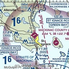
| Sectional chart |
|---|
|
| Airport distance calculator |
|---|
|
|
| Sunrise and sunset |
|---|
|
Times for 20-May-2026
| | Local
(UTC-4) | | Zulu
(UTC) |
|---|
| Morning civil twilight | | 05:27 | | 09:27 |
| Sunrise | | 06:03 | | 10:03 |
| Sunset | | 21:08 | | 01:08 |
| Evening civil twilight | | 21:44 | | 01:44 |
|
| Current date and time |
|---|
| Zulu (UTC) | 20-May-2026 19:07:28 |
|---|
| Local (UTC-4) | 20-May-2026 15:07:28 |
|---|
|
| METAR |
|---|
KMCD
5nm SE | 201855Z AUTO 33011KT 10SM CLR 11/M01 A3027 RMK AO2
|
KSLH
17nm SE | 201855Z AUTO 34013G18KT 10SM SCT041 11/00 A3027 RMK AO2
|
KPLN
20nm S | 201854Z AUTO 30012G22KT 10SM CLR 10/M01 A3028 RMK AO2 SLP259 T01001011
|
|
| TAF |
|---|
KPLN
20nm S | 201720Z 2018/2118 35015G25KT P6SM FEW030 FM210100 VRB04KT P6SM SKC FM211100 02007KT P6SM FEW030
|
KCIU
24nm NE | 201720Z 2018/2118 33015G25KT P6SM SCT025 FM210100 02004KT P6SM FEW030 FM211100 01007KT P6SM FEW030
|
|
| NOTAMs |
|---|
NOTAMs are issued by the DoD/FAA and will open in a separate window not controlled by AirNav.
|
|

