FAA INFORMATION EFFECTIVE 14 MAY 2026
Location
| FAA Identifier: | MCD |
| Lat/Long: | 45-51-53.9400N 084-38-13.5400W
45-51.899000N 084-38.225667W
45.8649833,-84.6370944
(estimated) |
| Elevation: | 741 ft. / 225.9 m (surveyed) |
| Variation: | 07W (2000) |
| From city: | 1 mile NW of MACKINAC ISLAND, MI |
| Time zone: | UTC -4 (UTC -5 during Standard Time) |
| Zip code: | 49757 |
Airport Operations
| Airport use: | Open to the public |
| Activation date: | 04/1940 |
| Control tower: | no |
| ARTCC: | MINNEAPOLIS CENTER |
| FSS: | GREEN BAY FLIGHT SERVICE STATION |
| NOTAMs facility: | MCD (NOTAM-D service available) |
| Attendance: | 0800-1700 |
| Pattern altitude: | 1900 ft. MSL |
| Wind indicator: | lighted |
| Segmented circle: | yes |
| Lights: | ACTVT REIL RWY 08 & 26; PAPI RWY 08 & 26; MIRL RWY 08/26 - 122.8. |
| Beacon: | white-green (lighted land airport)
Operates sunset to sunrise. |
| Landing fee: | yes |
Airport Communications
| CTAF/UNICOM: | 122.7 |
| WX AWOS-3P: | 118.275 (906-847-3778) |
| WX AWOS-3P at SLH (14 nm S): | 118.175 (231-627-4671) |
| WX ASOS at PLN (19 nm S): | 119.025 (231-539-7700) |
- APCH/DEP SVC PRVDD BY MINNEAPOLIS ARTCC ON FREQS 134.6/354.05 (PELLSTON RCAG).
Nearby radio navigation aids
| VOR radial/distance | | VOR name | | Freq | | Var |
|---|
| PLNr011/14.1 | | PELLSTON VORTAC | | 111.80 | | 06W |
| SSMr206/35.5 | | SAULT STE MARIE VOR/DME | | 112.20 | | 04W |
Airport Services
| Parking: | tiedowns |
| Airframe service: | NONE |
| Powerplant service: | NONE |
| Bottled oxygen: | NONE |
| Bulk oxygen: | NONE |
Runway Information
Runway 8/26
| Dimensions: | 3501 x 75 ft. / 1067 x 23 m |
| Surface: | asphalt/porous friction courses, in good condition |
| Weight bearing capacity: | |
| Runway edge lights: | medium intensity |
| RUNWAY 8 | | RUNWAY 26 |
| Latitude: | 45-51.825667N | | 45-51.972333N |
| Longitude: | 084-38.624333W | | 084-37.827167W |
| Elevation: | 728.7 ft. | | 741.0 ft. |
| Traffic pattern: | left | | left |
| Runway heading: | 082 magnetic, 075 true | | 262 magnetic, 255 true |
| Markings: | nonprecision, in good condition | | nonprecision, in good condition |
| Visual slope indicator: | 4-light PAPI on left (3.50 degrees glide path)
PAPI UNUSBL BYD 5 DEGS LEFT OF CNTRLN. | | 4-light PAPI on left (3.80 degrees glide path)
PAPI UNUSBL BYD 5 DEGS LEFT OF CNTRLN. |
| Runway end identifier lights: | yes | | yes |
| Touchdown point: | yes, no lights | | yes, no lights |
| Obstructions: | 29 ft. tree, 374 ft. from runway, 290 ft. left of centerline, 6:1 slope to clear
+4 FT FENCE, 0 FT DIST, 210 FT L/R. | | 34 ft. tree, 491 ft. from runway, 275 ft. left of centerline, 8:1 slope to clear |
Airport Ownership and Management from official FAA records
| Ownership: | Publicly-owned |
| Owner: | MACKINAC ISLAND STATE PARK CMSN
PO BOX 370
MACKINAC ISLAND, MI 49757-0370
Phone 906-847-3231 |
| Manager: | MYRON JOHNSON
PO BOX 370
MACKINAC ISLAND, MI 49757-0370
Phone 906-847-3231 |
Additional Remarks
| - | LRG BIRDS ON & INVOF ARPT; FLOCKS OF SEAGULLS INVOF LANDFILL 0.3 NM NE. |
| - | NOISE ABATEMENT PROCS: CLIMB TO TPA BFR TURNING; AVD FLT OVR SHORE & TOWN; TGL NA. |
| - | OBSTN LGTS ARE IN THE APCH TO RWY 26. |
| - | PITOT COVS RCMDD WHILE PARKED; CK TUBES BFR DEP DUE TO MUD DAUBERS. |
| - | FOR CD CTC MINNEAPOLIS ARTCC AT 651-463-5588. |
Instrument Procedures
NOTE: All procedures below are presented as PDF files. If you need a reader for these files, you should download the free Adobe Reader.NOT FOR NAVIGATION. Please procure official charts for flight.
FAA instrument procedures published for use from 14 May 2026 at 0901Z to 11 June 2026 at 0900Z.
IAPs - Instrument Approach Procedures |
|---|
| RNAV (GPS) RWY 08 | |
download (229KB) |
| RNAV (GPS) RWY 26 | |
download (253KB) |
| NOTE: Special Alternate Minimums apply **CHANGED** | |
download (140KB) |
| NOTE: Special Take-Off Minimums/Departure Procedures apply | |
download (122KB) |
Other nearby airports with instrument procedures:
83D - Mackinac County Airport (5 nm W)
6Y1 - Bois Blanc Island Airport (8 nm SE)
KSLH - Cheboygan County Airport (14 nm S)
KPLN - Pellston Regional/Emmet County Airport (19 nm S)
KCIU - Chippewa County International Airport (24 nm N)
|
|

Road maps at:
MapQuest
Bing
Google
| Aerial photo |
|---|
WARNING: Photo may not be current or correct
 looking southwest
Do you have a better or more recent aerial photo of Mackinac Island Airport that you would like to share? If so, please send us your photo.
|
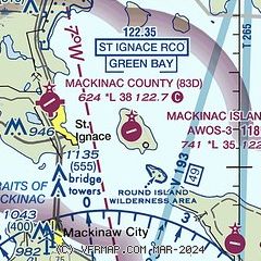
| Sectional chart |
|---|
|
| Airport distance calculator |
|---|
|
|
| Sunrise and sunset |
|---|
|
Times for 24-May-2026
| | Local
(UTC-4) | | Zulu
(UTC) |
|---|
| Morning civil twilight | | 05:22 | | 09:22 |
| Sunrise | | 05:59 | | 09:59 |
| Sunset | | 21:12 | | 01:12 |
| Evening civil twilight | | 21:48 | | 01:48 |
|
| Current date and time |
|---|
| Zulu (UTC) | 24-May-2026 04:02:08 |
|---|
| Local (UTC-4) | 24-May-2026 00:02:08 |
|---|
|
| METAR |
|---|
| KMCD | 240355Z AUTO 10013G17KT 1/2SM DZ FG VV005 05/05 A3009 RMK AO2 400890054
|
KSLH
14nm S | 240355Z AUTO 10011G16KT 10SM OVC004 07/06 A3008 RMK AO2 PRESFR 401550072
|
KPLN
19nm S | 240354Z AUTO 09009KT 10SM OVC006 08/06 A3008 RMK AO2 SLP188 T00780061
|
|
| TAF |
|---|
KPLN
19nm S | 240202Z 2402/2424 09011KT P6SM OVC007 FM240500 09005KT P6SM OVC006 FM241200 00000KT P6SM BKN015 FM241600 24004KT P6SM BKN018 FM242100 26006KT P6SM SCT021
|
|
| NOTAMs |
|---|
NOTAMs are issued by the DoD/FAA and will open in a separate window not controlled by AirNav.
|
|

