FAA INFORMATION EFFECTIVE 09 JULY 2026
Location
| FAA Identifier: | 84R |
| Lat/Long: | 30-01-41.5480N 097-10-01.3410W
30-01.692467N 097-10.022350W
30.0282078,-97.1670392
(estimated) |
| Elevation: | 323.2 ft. / 98.5 m (surveyed) |
| Variation: | 03E (2025) |
| From city: | 2 miles N of SMITHVILLE, TX |
| Time zone: | UTC -5 (UTC -6 during Standard Time) |
| Zip code: | 78957 |
Airport Operations
| Airport use: | Open to the public |
| Activation date: | 04/1971 |
| Control tower: | no |
| ARTCC: | HOUSTON CENTER |
| FSS: | SAN ANGELO FLIGHT SERVICE STATION |
| NOTAMs facility: | SJT (NOTAM-D service available) |
| Attendance: | MON-SAT 0900-1700
AFTR HRS ATNDT 979-224-6304. |
| Wind indicator: | lighted |
| Segmented circle: | yes |
| Lights: | SS-SR ACTVT MIRL RWY 17/35 - 123.3. |
| Beacon: | white-green (lighted land airport)
Operates sunset to sunrise. |
Airport Communications
| CTAF: | 122.9 |
| AUSTIN APPROACH: | 120.875 |
| AUSTIN DEPARTURE: | 120.875 |
| WX AWOS-3 at GYB (13 nm NE): | 119.225 (979-542-0382) |
| WX AWOS-3 at 3T5 (13 nm SE): | 124.175 (979-242-5777) |
Nearby radio navigation aids
| VOR radial/distance | | VOR name | | Freq | | Var |
|---|
| CWKr132/28.2 | | CENTEX VORTAC | | 112.80 | | 06E |
Airport Services
| Fuel available: | 100LL |
| Parking: | hangars and tiedowns |
| Airframe service: | MAJOR |
| Powerplant service: | MAJOR |
| Bottled oxygen: | NONE |
| Bulk oxygen: | NONE |
Runway Information
Runway 17/35
| Dimensions: | 4000 x 75 ft. / 1219 x 23 m |
| Surface: | asphalt, in good condition |
| Weight bearing capacity: | |
| Runway edge lights: | medium intensity |
| RUNWAY 17 | | RUNWAY 35 |
| Latitude: | 30-02.019148N | | 30-01.365798N |
| Longitude: | 097-10.075680W | | 097-09.969027W |
| Elevation: | 323.2 ft. | | 322.0 ft. |
| Traffic pattern: | left | | left |
| Runway heading: | 169 magnetic, 172 true | | 349 magnetic, 352 true |
| Markings: | nonprecision, in good condition | | nonprecision, in good condition |
| Visual slope indicator: | 2-light PAPI on left (4.00 degrees glide path) | | 2-light PAPI on left (3.00 degrees glide path) |
| Touchdown point: | yes, no lights | | yes, no lights |
| Obstructions: | 106 ft. trees, 2200 ft. from runway, 30 ft. left of centerline, 18:1 slope to clear | | 45 ft. pline, marked and lighted, 1380 ft. from runway, 680 ft. left and right of centerline, 26:1 slope to clear |
Airport Ownership and Management from official FAA records
| Ownership: | Publicly-owned |
| Owner: | CITY OF SMITHVILLE
PO BOX 449
SMITHVILLE, TX 78957
Phone 512-237-3282 |
| Manager: | MR. SANDY MEYERSON
BOX 449
SMITHVILLE, TX 78957
Phone 512-237-3282 |
Additional Remarks
| - | WILDLIFE & LIVESTOCK INVOF ARPT. |
| - | FOR CD CTC AUSTIN APCH AT 512-369-7865. |
Instrument Procedures
NOTE: All procedures below are presented as PDF files. If you need a reader for these files, you should download the free Adobe Reader.NOT FOR NAVIGATION. Please procure official charts for flight.
FAA instrument procedures published for use from 09 July 2026 at 0901Z to 06 August 2026 at 0900Z.
IAPs - Instrument Approach Procedures |
|---|
| RNAV (GPS) RWY 17 | |
download (165KB) |
| RNAV (GPS) RWY 35 | |
download (184KB) |
| NOTE: Special Take-Off Minimums/Departure Procedures apply | |
download (303KB) |
Other nearby airports with instrument procedures:
KGYB - Giddings-Lee County Airport (13 nm NE)
3T5 - Fayette Regional Air Center Airport (13 nm SE)
KAUS - Austin-Bergstrom International Airport (28 nm W)
50R - Lockhart Municipal Airport (28 nm W)
KEDC - Austin Executive Airport (30 nm NW)
|
|

Road maps at:
MapQuest
Bing
Google
| Aerial photo |
|---|
WARNING: Photo may not be current or correct
 Photo by Sandy Meyerson
Photo taken 15-Dec-2023
looking South.
Photo by Sandy Meyerson
Photo taken 15-Dec-2023
looking South.
Do you have a better or more recent aerial photo of Smithville Crawford Municipal Airport that you would like to share? If so, please send us your photo.
|
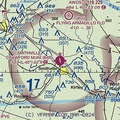
| Sectional chart |
|---|
|
| Airport distance calculator |
|---|
|
|
| Sunrise and sunset |
|---|
|
Times for 26-Jul-2026
| | Local
(UTC-5) | | Zulu
(UTC) |
|---|
| Morning civil twilight | | 06:19 | | 11:19 |
| Sunrise | | 06:45 | | 11:45 |
| Sunset | | 20:25 | | 01:25 |
| Evening civil twilight | | 20:52 | | 01:52 |
|
| Current date and time |
|---|
| Zulu (UTC) | 27-Jul-2026 04:58:21 |
|---|
| Local (UTC-5) | 26-Jul-2026 23:58:21 |
|---|
|
| METAR |
|---|
KGYB
13nm NE | 270435Z AUTO 19006KT 10SM CLR 28/22 A3003 RMK AO2 T02800220
|
K3T5
14nm SE | 270455Z AUTO 18007KT 10SM CLR 27/24 A2999 RMK AO2 T02730242 $
|
|
| TAF |
|---|
KAUS
32nm NW | 270257Z 2706/2812 19003KT P6SM FEW070 FEW300 FM271000 19004KT P6SM SCT015 TEMPO 2710/2714 BKN015 FM271700 19011KT P6SM FEW060 FM280000 17011KT P6SM SKC
|
|
| NOTAMs |
|---|
NOTAMs are issued by the DoD/FAA and will open in a separate window not controlled by AirNav.
|
|

