FAA INFORMATION EFFECTIVE 14 MAY 2026
Location
| FAA Identifier: | 50R |
| Lat/Long: | 29-51-01.2000N 097-40-20.7000W
29-51.020000N 097-40.345000W
29.8503333,-97.6724167
(estimated) |
| Elevation: | 531.6 ft. / 162.0 m (surveyed) |
| Variation: | 07E (1985) |
| From city: | 2 miles S of LOCKHART, TX |
| Time zone: | UTC -5 (UTC -6 during Standard Time) |
| Zip code: | 78644 |
Airport Operations
| Airport use: | Open to the public |
| Activation date: | 11/1949 |
| Control tower: | no |
| ARTCC: | HOUSTON CENTER |
| FSS: | SAN ANGELO FLIGHT SERVICE STATION |
| NOTAMs facility: | SJT (NOTAM-D service available) |
| Attendance: | 0800-1700 |
| Wind indicator: | lighted |
| Segmented circle: | yes |
| Lights: | DUSK-DAWN. MIRL RWY 18/36 PRESET LOW INTST; TO INCR INTST ACTVT - CTAF. |
| Beacon: | white-green (lighted land airport)
Operates sunset to sunrise. |
Airport Communications
| CTAF/UNICOM: | 122.8 |
| AUSTIN APPROACH: | 120.875 |
| AUSTIN DEPARTURE: | 120.875 |
| WX AWOS-3PT at HYI (10 nm W): | PHONE 512-353-8005 |
Nearby radio navigation aids
| VOR radial/distance | | VOR name | | Freq | | Var |
|---|
| CWKr187/32.5 | | CENTEX VORTAC | | 112.80 | | 06E |
| RNDr053/37.6 | | RANDOLPH VORTAC | | 112.30 | | 05E |
Airport Services
| Fuel available: | 100LL |
| Parking: | hangars and tiedowns |
| Airframe service: | MAJOR |
| Powerplant service: | MAJOR |
| Bulk oxygen: | NONE |
Runway Information
Runway 18/36
| Dimensions: | 4001 x 75 ft. / 1220 x 23 m |
| Surface: | asphalt, in fair condition |
| Weight bearing capacity: | |
| Runway edge lights: | medium intensity |
| RUNWAY 18 | | RUNWAY 36 |
| Latitude: | 29-51.349613N | | 29-50.689872N |
| Longitude: | 097-40.331762W | | 097-40.357707W |
| Elevation: | 531.5 ft. | | 524.0 ft. |
| Traffic pattern: | left | | left |
| Runway heading: | 175 magnetic, 182 true | | 355 magnetic, 002 true |
| Markings: | nonprecision, in good condition | | nonprecision, in good condition |
| Visual slope indicator: | 2-light PAPI on left (3.50 degrees glide path) | | 2-light PAPI on left (3.00 degrees glide path) |
| Touchdown point: | yes, no lights | | yes, no lights |
| Obstructions: | 12 ft. tree, 355 ft. from runway, 220 ft. right of centerline, 12:1 slope to clear | | 21 ft. tree, 228 ft. from runway, 80 ft. left of centerline, 1:1 slope to clear
10 FT TREE, 3 FT DSTC 172 FT L. |
Airport Ownership and Management from official FAA records
| Ownership: | Publicly-owned |
| Owner: | CITY OF LOCKHART
PO BOX 239
LOCKHART, TX 78644
Phone 512-398-3461 |
| Manager: | SEAN KELLEY
PO BOX 239
LOCKHART, TX 78644
Phone 512-398-6452
PUBLIC WORKS |
Additional Remarks
| - | WILDLIFE INVOF ARPT. |
| - | FOR CD CTC AUSTIN APCH AT 512-369-7865. |
Instrument Procedures
NOTE: All procedures below are presented as PDF files. If you need a reader for these files, you should download the free Adobe Reader.NOT FOR NAVIGATION. Please procure official charts for flight.
FAA instrument procedures published for use from 14 May 2026 at 0901Z to 11 June 2026 at 0900Z.
IAPs - Instrument Approach Procedures |
|---|
| RNAV (GPS) RWY 18 | |
download (205KB) |
| RNAV (GPS) RWY 36 | |
download (225KB) |
| NOTE: Special Take-Off Minimums/Departure Procedures apply | |
download (105KB) |
Other nearby airports with instrument procedures:
KHYI - San Marcos Regional Airport (10 nm W)
KAUS - Austin-Bergstrom International Airport (21 nm N)
KBAZ - New Braunfels National Airport (21 nm SW)
84R - Smithville Crawford Municipal Airport (28 nm E)
KEDC - Austin Executive Airport (33 nm N)
|
|

Road maps at:
MapQuest
Bing
Google
| Aerial photo |
|---|
WARNING: Photo may not be current or correct
 Photo by Feng Ma
Do you have a better or more recent aerial photo of Lockhart Municipal Airport that you would like to share? If so, please send us your photo.
|
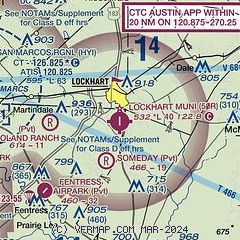
| Sectional chart |
|---|
|
| Airport distance calculator |
|---|
|
|
| Sunrise and sunset |
|---|
|
Times for 19-May-2026
| | Local
(UTC-5) | | Zulu
(UTC) |
|---|
| Morning civil twilight | | 06:10 | | 11:10 |
| Sunrise | | 06:36 | | 11:36 |
| Sunset | | 20:18 | | 01:18 |
| Evening civil twilight | | 20:44 | | 01:44 |
|
| Current date and time |
|---|
| Zulu (UTC) | 19-May-2026 17:31:39 |
|---|
| Local (UTC-5) | 19-May-2026 12:31:39 |
|---|
|
| METAR |
|---|
KHYI
10nm W | 191656Z 17014G19KT 10SM CLR 31/21 A2999 RMK AO2 SLP147 T03060206
|
|
| NOTAMs |
|---|
NOTAMs are issued by the DoD/FAA and will open in a separate window not controlled by AirNav.
|
|


