FAA INFORMATION EFFECTIVE 22 JANUARY 2026
Location
| FAA Identifier: | 87MO |
| Lat/Long: | 38-41-46.0390N 094-15-28.8050W
38-41.767317N 094-15.480083W
38.6961219,-94.2580014
(estimated) |
| Elevation: | 915 ft. / 279 m (estimated) |
| Variation: | 05E (1985) |
| From city: | 3 miles NW of EAST LYNNE, MO |
| Time zone: | UTC -6 (UTC -5 during Daylight Saving Time) |
| Zip code: | 64080 |
Airport Operations
| Airport use: | Private use. Permission required prior to landing |
| Activation date: | 04/1969 |
| Control tower: | no |
| ARTCC: | KANSAS CITY CENTER |
| FSS: | COLUMBIA FLIGHT SERVICE STATION |
| Attendance: | MON-SAT DAYLIGHT HOURS |
| Wind indicator: | yes |
| Segmented circle: | no |
Airport Communications
| WX AWOS-3PT at LRY (7 nm SW): | 119.975 (816-380-5936) |
| WX ASOS at LXT (17 nm N): | 124.175 (816-347-9807) |
Nearby radio navigation aids
| VOR radial/distance | | VOR name | | Freq | | Var |
|---|
| ANXr187/24.7 | | NAPOLEON VORTAC | | 115.15 | | 07E |
| BUMr016/27.6 | | BUTLER VORTAC | | 115.90 | | 07E |
Airport Services
| Parking: | tiedowns |
| Airframe service: | MAJOR |
| Powerplant service: | MAJOR |
| Bottled oxygen: | NONE |
| Bulk oxygen: | NONE |
Runway Information
Runway 18/36
| Dimensions: | 3000 x 85 ft. / 914 x 26 m |
| Surface: | turf/gravel, in good condition |
| RUNWAY 18 | | RUNWAY 36 |
| Traffic pattern: | left | | left |
| Markings: | none | | none |
| Runway end identifier lights: | no | | no |
| Obstructions: | 15 ft. road
+7' FC, 20' FM RWY END, B; +30' TREES, 20' FM RWY END, 75-125'R; +15' RD, AT RWY END, 50'L; +9' FC, AT RWY END, 75'L. | | 17 ft. road, 50 ft. right of centerline
+1' FENCE AT RWY END LEFT. |
Airport Ownership and Management from official FAA records
| Ownership: | Privately-owned |
| Owner: | RONALD L. RICHTER
RR 1
PLEASANT HILL, MO 64080
Phone 816-869-3374 |
| Manager: | RONALD L. RICHTER
RR 1
PLEASANT HILL, MO 64080
Phone 816-869-3374 |
Additional Remarks
| - | TREES, TIE DOWN AREA, HGR, RD, FCS & HIGH GND IN PRIM SFC; VIOLATIONS OF 7:1 HIGH GND, TREES & FC, EAST SIDE; TIE DOWN AREA & TREES WEST SIDE; TREES, HOUSE & RD NORTH END; RD & HIGH GND SOUTH END. |
| - | RWY 18 FIRST 400' ROLLING & UNEVEN. |
| - | FOR CD CTC KANSAS CITY APCH AT 816-329-2710. |
| - | GLIDER OPS INVOF ARPT. |
Instrument Procedures
There are no published instrument procedures at 87MO.
Some nearby airports with instrument procedures:
KLRY - Lawrence Smith Memorial Airport (7 nm SW)
KLXT - Kansas City/Lee's Summit Regional Airport (17 nm N)
3GV - East Kansas City Airport (19 nm N)
KRCM - Skyhaven Airport (22 nm E)
KOJC - Johnson County Executive Airport (24 nm W)
|
|

Road maps at:
MapQuest
Bing
Google
| Aerial photo |
|---|

|
| Sectional chart |
|---|
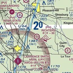
|
| Airport distance calculator |
|---|
|
|
| Sunrise and sunset |
|---|
|
Times for 11-Feb-2026
| | Local
(UTC-6) | | Zulu
(UTC) |
|---|
| Morning civil twilight | | 06:46 | | 12:46 |
| Sunrise | | 07:14 | | 13:14 |
| Sunset | | 17:49 | | 23:49 |
| Evening civil twilight | | 18:16 | | 00:16 |
|
| Current date and time |
|---|
| Zulu (UTC) | 11-Feb-2026 20:04:54 |
|---|
| Local (UTC-6) | 11-Feb-2026 14:04:54 |
|---|
|
| METAR |
|---|
KLRY
7nm SW | 111955Z AUTO 17003KT 10SM CLR 11/M06 A3034 RMK AO2
|
KGVW
17nm NW | 111955Z AUTO 18009KT 10SM BKN070 21/19 A3014 RMK A01
|
KLXT
17nm N | 111953Z AUTO 14004KT 10SM CLR 09/M07 A3031 RMK AO2 SLP268 T00891072
|
|
| TAF |
|---|
KMKC
30nm NW | 111720Z 1118/1218 14005KT P6SM SCT250
|
KIXD
30nm W | 111720Z 1118/1218 12006KT P6SM SCT250
|
KSZL
34nm E | 111100Z 1111/1217 02009KT 9999 SKC QNH3030INS BECMG 1117/1118 06009KT 9999 SKC QNH3028INS BECMG 1203/1204 13009KT 9999 SKC QNH3027INS BECMG 1207/1208 13009KT 9999 SCT160 QNH3025INS BECMG 1215/1216 16010G15KT 9999 SCT220 QNH3022INS TX11/1121Z TNM02/1112Z
|
|
| NOTAMs |
|---|
NOTAMs are issued by the DoD/FAA and will open in a separate window not controlled by AirNav.
|
|

