FAA INFORMATION EFFECTIVE 16 APRIL 2026
Location
| FAA Identifier: | 8A7 |
| Lat/Long: | 35-54-53.6940N 080-27-24.5030W
35-54.894900N 080-27.408383W
35.9149150,-80.4568064
(estimated) |
| Elevation: | 818 ft. / 249.3 m (surveyed) |
| Variation: | 06W (1985) |
| From city: | 5 miles NE of MOCKSVILLE, NC |
| Time zone: | UTC -4 (UTC -5 during Standard Time) |
| Zip code: | 27006 |
Airport Operations
| Airport use: | Open to the public |
| Control tower: | no |
| ARTCC: | ATLANTA CENTER |
| FSS: | RALEIGH FLIGHT SERVICE STATION |
| NOTAMs facility: | RDU (NOTAM-D service available) |
| Attendance: | 0800-1700 |
| Wind indicator: | yes |
| Segmented circle: | no |
| Lights: | SS-SR |
| Beacon: | white-green (lighted land airport)
Operates sunset to sunrise. |
Airport Communications
| CTAF/UNICOM: | 122.7 |
| GREENSBORO APPROACH: | 124.35 |
| GREENSBORO DEPARTURE: | 124.35 |
| WX AWOS-3 at EXX (11 nm SE): | 119.825 (336-956-2967) |
| WX AWOS-3P at RUQ (16 nm S): | 118.175 (704-637-6197) |
| WX ASOS at INT (17 nm NE): | PHONE 336-661-3096 |
Nearby radio navigation aids
| VOR radial/distance | | VOR name | | Freq | | Var |
|---|
| GSOr254/24.6 | | GREENSBORO VORTAC | | 116.20 | | 03W |
| BZMr092/38.2 | | BARRETTS MOUNTAIN VOR/DME | | 113.75 | | 06W |
| NDB name | | Hdg/Dist | | Freq | | Var | | ID |
|---|
| ROVDY | | 014/11.0 | | 275 | | 06W | | RU | .-. ..- |
Airport Services
| Fuel available: | 100LL
100LL:24 HR SELF SERVICE WITH CC. |
| Parking: | tiedowns |
| Airframe service: | MAJOR |
| Powerplant service: | MAJOR |
| Bottled oxygen: | LOW |
| Bulk oxygen: | NONE |
Runway Information
Runway 9/27
| Dimensions: | 2943 x 50 ft. / 897 x 15 m |
| Surface: | asphalt, in good condition |
| Weight bearing capacity: | |
| Runway edge lights: | non-standard
RWY 09/27 NSTD LIGHTING DUE TO NUMBER AND LOCATION. |
| Runway edge markings: | RWY 27 MARKINGS NONSTANDARD DUE TO SIZE AND LOCATION. |
| RUNWAY 9 | | RUNWAY 27 |
| Latitude: | 35-54.886633N | | 35-54.902933N |
| Longitude: | 080-27.706933W | | 080-27.111000W |
| Elevation: | 773.0 ft. | | 818.0 ft. |
| Traffic pattern: | left | | left |
| Runway heading: | 094 magnetic, 088 true | | 274 magnetic, 268 true |
| Markings: | NSTD, in good condition | | NSTD, in good condition |
| Visual slope indicator: | 2-light PAPI on left (3.50 degrees glide path) | | |
| Touchdown point: | yes, no lights | | yes, no lights |
| Obstructions: | 11 ft. trees, 222 ft. from runway, 18 ft. left of centerline, 2:1 slope to clear
HAS 10-15 FT BRUSH STARTING 0-200 FT FM THR OFFSET 37-58 FT R OF CNTRLN AND HAS 12-31 FT BRUSH 0-200 FT FM THR OFFSET 55-95 FT L OF CNTRLN. | | 75 ft. trees, 401 ft. from runway, 186 ft. right of centerline, 2:1 slope to clear |
Airport Ownership and Management from official FAA records
| Ownership: | Privately-owned |
| Owner: | DR. PHILIP MARTIN
644 HOLLY SPRINGS ROAD, SUITE 161
HOLLY SPRINGS, NC 27540
Phone 919-571-0081 |
| Manager: | BRIAN MEADOWS
1105 FORK BIXBY RD
ADVANCE, NC 27006
Phone 336-998-8101 |
Additional Remarks
| - | RWY 09 -18 FT DROP-OFF 150 FT FROM THR LEFT & RIGHT OF CNTRLN. |
| - | RWY 09 UPHILL GRADE. |
| - | DEER/MIGRATORY BIRDS OCNLLY ON ARPT. |
| - | FOR CD CTC GREENSBORO APCH AT 336-333-5119. |
| - | FOR AFT HRS SVC CTC 336-998-2126. |
Instrument Procedures
NOTE: All procedures below are presented as PDF files. If you need a reader for these files, you should download the free Adobe Reader.NOT FOR NAVIGATION. Please procure official charts for flight.
FAA instrument procedures published for use from 16 April 2026 at 0901Z to 14 May 2026 at 0900Z.
IAPs - Instrument Approach Procedures |
|---|
| RNAV (GPS) RWY 09 **CHANGED** | |
download (211KB) |
| NOTE: Special Take-Off Minimums/Departure Procedures apply | |
download (141KB) |
Other nearby airports with instrument procedures:
KEXX - Davidson County Executive Airport (11 nm SE)
KRUQ - Mid-Carolina Regional Airport (16 nm S)
KINT - Smith Reynolds Airport (17 nm NE)
KSVH - Statesville Regional Airport (26 nm W)
KZEF - Elkin Municipal Airport (27 nm NW)
|
|

Road maps at:
MapQuest
Bing
Google
| Aerial photo |
|---|
WARNING: Photo may not be current or correct
 Photo by Louis Guillama, CRS
Photo taken 20-Nov-2014
looking west.
Photo by Louis Guillama, CRS
Photo taken 20-Nov-2014
looking west.
Do you have a better or more recent aerial photo of Twin Lakes Airport that you would like to share? If so, please send us your photo.
|
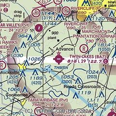
| Sectional chart |
|---|
|
| Airport distance calculator |
|---|
|
|
| Sunrise and sunset |
|---|
|
Times for 25-Apr-2026
| | Local
(UTC-4) | | Zulu
(UTC) |
|---|
| Morning civil twilight | | 06:10 | | 10:10 |
| Sunrise | | 06:37 | | 10:37 |
| Sunset | | 20:02 | | 00:02 |
| Evening civil twilight | | 20:29 | | 00:29 |
|
| Current date and time |
|---|
| Zulu (UTC) | 25-Apr-2026 11:31:15 |
|---|
| Local (UTC-4) | 25-Apr-2026 07:31:15 |
|---|
|
| METAR |
|---|
KEXX
11nm SE | 251115Z AUTO 00000KT 10SM CLR 12/12 A2983 RMK AO2 T01160116
|
KRUQ
16nm S | 251115Z AUTO 00000KT 10SM CLR 13/11 A2983 RMK AO2 T01280105
|
|
| TAF |
|---|
KINT
18nm NE | 250520Z 2506/2606 23005KT P6SM SCT120 FM251600 23010G16KT P6SM BKN120 FM252100 26008KT P6SM -RA OVC080 AMD NOT SKED
|
|
| NOTAMs |
|---|
NOTAMs are issued by the DoD/FAA and will open in a separate window not controlled by AirNav.
|
|

