FAA INFORMATION EFFECTIVE 11 JUNE 2026
Location
| FAA Identifier: | ZEF |
| Lat/Long: | 36-16-48.0000N 080-47-09.8000W
36-16.800000N 080-47.163333W
36.2800000,-80.7860556
(estimated) |
| Elevation: | 1067.2 ft. / 325.3 m (surveyed) |
| Variation: | 08W (2015) |
| From city: | 3 miles NE of ELKIN, NC |
| Time zone: | UTC -4 (UTC -5 during Standard Time) |
| Zip code: | 28621 |
Airport Operations
| Airport use: | Open to the public |
| Control tower: | no |
| ARTCC: | ATLANTA CENTER |
| FSS: | RALEIGH FLIGHT SERVICE STATION |
| NOTAMs facility: | RDU (NOTAM-D service available) |
| Attendance: | 0900-1700 |
| Pattern altitude: | MIN ALT 500 FT AGL BASE TURN TO FINAL RWY 25. |
| Wind indicator: | lighted |
| Segmented circle: | yes |
| Lights: | ACTVT REIL RWY 07 & 25; PAPI RWY 07 & 25; MIRL RWY 07/25 - CTAF. |
| Beacon: | white-green (lighted land airport)
Operates sunset to sunrise. |
Airport Communications
| CTAF/UNICOM: | 123.05 |
| WX AWOS-3 at UKF (15 nm W): | 126.625 (336-696-3788) |
| WX AWOS-3PT at MWK (16 nm NE): | 121.125 (336-789-2299) |
- APCH/DEP SVC PRVDD BY ATLANTA ARTCC ON FREQS 125.15/263.0 (HICKORY RCAG).
Nearby radio navigation aids
| VOR radial/distance | | VOR name | | Freq | | Var |
|---|
| BZMr048/33.1 | | BARRETTS MOUNTAIN VOR/DME | | 113.75 | | 06W |
Airport Services
| Fuel available: | 100LL JET-A1+
100LL:24 HR SELF SERVICE W/ CREDIT CARD. |
| Parking: | hangars and tiedowns |
| Airframe service: | MAJOR |
| Powerplant service: | MAJOR |
| Bottled oxygen: | HIGH/LOW |
| Bulk oxygen: | NONE |
Runway Information
Runway 7/25
| Dimensions: | 4001 x 75 ft. / 1220 x 23 m |
| Surface: | asphalt, in good condition |
| Weight bearing capacity: | |
| Runway edge lights: | medium intensity |
| RUNWAY 7 | | RUNWAY 25 |
| Latitude: | 36-16.669232N | | 36-16.932188N |
| Longitude: | 080-47.537362W | | 080-46.790572W |
| Elevation: | 1067.0 ft. | | 1036.8 ft. |
| Traffic pattern: | left | | left |
| Runway heading: | 075 magnetic, 067 true | | 255 magnetic, 247 true |
| Markings: | nonprecision, in good condition | | nonprecision, in good condition |
| Visual slope indicator: | 2-light PAPI on left (3.00 degrees glide path)
UNUSBL 7 DEG LEFT AND RIGHT OF RCL. | | 2-light PAPI on left (3.00 degrees glide path)
UNUSBL 9 DEG RIGHT OF RCL. |
| Runway end identifier lights: | yes | | yes |
| Touchdown point: | yes, no lights | | yes, no lights |
| Obstructions: | 26 ft. trees, 394 ft. from runway, 147 ft. right of centerline, 7:1 slope to clear | | 50 ft. trees, 331 ft. from runway, 203 ft. right of centerline, 2:1 slope to clear
56 FT TREES 171 FT FM THR OFFSET 228 FT RIGHT OF CNTRLN. |
Airport Ownership and Management from official FAA records
| Ownership: | Publicly-owned |
| Owner: | TOWN OF ELKIN
TOWN HALL - PO BOX 857
ELKIN, NC 28621
Phone (336) 794-6464 |
| Manager: | STEVE (SANDY) SHORE
1598 CC CAMP ROAD
ELKIN, NC 28621
Phone 336-366-3433 |
Additional Remarks
| - | RWY 07 SAFETY AREA HAS 80+ FT DROP-OFF AT END AND 90 FT BOTH SIDES OF CNTRLN. |
| - | DEER ON AND INVOF ARPT. |
| - | RWY 25 HAS AN UPHILL GRADE. |
| - | FOR SERVICE AFTER HOURS CALL (336)-874-7171, (336)-874-2931, (336)-366-7994, OR (336)-926-6243. |
| - | FOR CD CTC ATLANTA ARTCC AT 770-210-7692. |
| - | RWY 25 HAS UP TO 100+ FT DROP-OFF FIRST 600 FT AND 90 FT BOTH SIDES OF CNTRLN. |
| - | RWY 25 HAS UNMARKED POWER LINES 800 FT FM THR BOTH SIDES OF CNTRLN. |
Instrument Procedures
NOTE: All procedures below are presented as PDF files. If you need a reader for these files, you should download the free Adobe Reader.NOT FOR NAVIGATION. Please procure official charts for flight.
FAA instrument procedures published for use from 11 June 2026 at 0901Z to 09 July 2026 at 0900z.
IAPs - Instrument Approach Procedures |
|---|
| RNAV (GPS) RWY 07 | |
download (198KB) |
| RNAV (GPS) RWY 25 | |
download (195KB) |
| NOTE: Special Take-Off Minimums/Departure Procedures apply | |
download |
Other nearby airports with instrument procedures:
KUKF - Wilkes County Airport (15 nm W)
KMWK - Mount Airy/Surry County Airport (16 nm NE)
8A7 - Twin Lakes Airport (27 nm SE)
KINT - Smith Reynolds Airport (29 nm E)
KHLX - Twin County Airport (29 nm N)
|
|

Road maps at:
MapQuest
Bing
Google
| Aerial photo |
|---|
WARNING: Photo may not be current or correct
 Photo taken 15-Oct-2015
looking northwest.
Photo taken 15-Oct-2015
looking northwest.
Do you have a better or more recent aerial photo of Elkin Municipal Airport that you would like to share? If so, please send us your photo.
|
| Sectional chart |
|---|
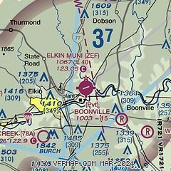
|
| Airport distance calculator |
|---|
|
|
| Sunrise and sunset |
|---|
|
Times for 12-Jun-2026
| | Local
(UTC-4) | | Zulu
(UTC) |
|---|
| Morning civil twilight | | 05:36 | | 09:36 |
| Sunrise | | 06:06 | | 10:06 |
| Sunset | | 20:40 | | 00:40 |
| Evening civil twilight | | 21:10 | | 01:10 |
|
| Current date and time |
|---|
| Zulu (UTC) | 12-Jun-2026 13:41:25 |
|---|
| Local (UTC-4) | 12-Jun-2026 09:41:25 |
|---|
|
| METAR |
|---|
KUKF
16nm W | 121315Z AUTO 00000KT 10SM CLR 27/21 A3005 RMK AO2
|
KMWK
16nm NE | 121315Z AUTO 24005KT 10SM CLR 28/21 A3001 RMK AO2
|
KHLX
29nm N | 121315Z AUTO 28013G18KT 250V320 10SM SCT019 SCT024 25/20 A3006 RMK AO2
|
|
| TAF |
|---|
KINT
29nm E | 121120Z 1212/1312 24005KT P6SM SCT180 FM121400 27009KT P6SM SCT050 SCT180 PROB30 1221/1301 5SM -TSRA BR BKN035CB BKN060 FM130200 34004KT P6SM SCT080 SCT200 AMD NOT SKED
|
|
| NOTAMs |
|---|
NOTAMs are issued by the DoD/FAA and will open in a separate window not controlled by AirNav.
|
|

