FAA INFORMATION EFFECTIVE 14 MAY 2026
Location
| FAA Identifier: | EXX |
| Lat/Long: | 35-46-52.1090N 080-18-13.5840W
35-46.868483N 080-18.226400W
35.7811414,-80.3037733
(estimated) |
| Elevation: | 732.5 ft. / 223.3 m (surveyed) |
| Variation: | 07W (2000) |
| From city: | 3 miles SW of LEXINGTON, NC |
| Time zone: | UTC -4 (UTC -5 during Standard Time) |
| Zip code: | 27292 |
Airport Operations
| Airport use: | Open to the public |
| Activation date: | 05/1961 |
| Control tower: | no |
| ARTCC: | ATLANTA CENTER |
| FSS: | RALEIGH FLIGHT SERVICE STATION |
| NOTAMs facility: | EXX (NOTAM-D service available) |
| Attendance: | 0800-1900
FOR SVC AFT HRS CALL 336-847-2983. UNATNDD JULY 4TH, THANKSGIVING, CHRISTMAS, NEW YEARS DAY. |
| Wind indicator: | lighted |
| Segmented circle: | yes |
| Lights: | ACTVT MALSR RWY 06; REILS RWY 24; PAPI RWY 06 & 24; MIRL RWY 06/24 - CTAF. |
| Beacon: | white-green (lighted land airport)
Operates sunset to sunrise. |
Airport Communications
| CTAF/UNICOM: | 122.8 |
| WX AWOS-3: | 119.825 (336-956-2967) |
| GREENSBORO APPROACH: | 126.6 |
| GREENSBORO DEPARTURE: | 126.6 |
| WX AWOS-3P at RUQ (13 nm SW): | 118.175 (704-637-6197) |
Nearby radio navigation aids
| VOR radial/distance | | VOR name | | Freq | | Var |
|---|
| GSOr228/22.5 | | GREENSBORO VORTAC | | 116.20 | | 03W |
| LIBr270/33.7 | | LIBERTY VORTAC | | 113.00 | | 03W |
| NDB name | | Hdg/Dist | | Freq | | Var | | ID |
|---|
| ROVDY | | 078/9.5 | | 275 | | 06W | | RU | .-. ..- |
Airport Services
| Fuel available: | 100LL JET-A+
100LL:100LL 24 HR SELF SVC WITH CREDIT CARD. |
| Parking: | hangars and tiedowns |
| Airframe service: | MAJOR |
| Powerplant service: | MAJOR |
| Bottled oxygen: | NONE |
| Bulk oxygen: | NONE |
Runway Information
Runway 6/24
| Dimensions: | 5004 x 100 ft. / 1525 x 30 m |
| Surface: | asphalt/grooved, in excellent condition |
| Weight bearing capacity: | | Single wheel: | 17.0 | | Double wheel: | 60.0 |
|
| Runway edge lights: | medium intensity |
| RUNWAY 6 | | RUNWAY 24 |
| Latitude: | 35-46.607213N | | 35-47.129720N |
| Longitude: | 080-18.617878W | | 080-17.834873W |
| Elevation: | 732.4 ft. | | 701.5 ft. |
| Traffic pattern: | left | | left |
| Runway heading: | 058 magnetic, 051 true | | 238 magnetic, 231 true |
| Markings: | precision, in fair condition | | nonprecision, in fair condition |
| Visual slope indicator: | 2-light PAPI on left (4.00 degrees glide path) | | 2-light PAPI on left (3.00 degrees glide path) |
| Approach lights: | MALSR: 1,400 foot medium intensity approach lighting system with runway alignment indicator lights | | |
| Runway end identifier lights: | | | yes |
| Touchdown point: | yes, no lights | | yes, no lights |
| Instrument approach: | ILS/DME | | |
| Obstructions: | 50 ft. trees, 1879 ft. from runway, 684 ft. left of centerline, 33:1 slope to clear | | 26 ft. trees, 453 ft. from runway, 39 ft. left of centerline, 9:1 slope to clear |
Airport Ownership and Management from official FAA records
| Ownership: | Publicly-owned |
| Owner: | DAVIDSON COUNTY ARPT AUTH
1673 AVIATION WAY
LEXINGTON, NC 27292
Phone 336-956-7774 |
| Manager: | KAREL VAN DER LINDEN
1673 AVIATION WAY
LEXINGTON, NC 27292
Phone 336-956-7774 |
Additional Remarks
| A39-06/24 | PCR VALUE: 369/F/C/X/T |
| - | WILDLIFE ON & INVOF ARPT. |
| - | TWY A FM RWY 24 TO TWY A3 HAS DROP-OFF UP TO 60 FT 20 FT FM PAVEMENT EDGE. |
| - | FOR CD CTC GREENSBORO APCH AT 743-222-6129. FOR CD IF UNA VIA GCO CTC ATLANTA ARTCC AT 770-210-7692. |
| - | GCO AVBL ON FREQ 135.075 THRU GSO CD & FLT SVCS. |
| - | MAX RAMP WT 30000 LBS SINGLE WHEEL, 60000 LBS DUAL WHEEL. |
| - | FOLLOW TWY CNTRLN TO PRKG. |
Instrument Procedures
NOTE: All procedures below are presented as PDF files. If you need a reader for these files, you should download the free Adobe Reader.NOT FOR NAVIGATION. Please procure official charts for flight.
FAA instrument procedures published for use from 14 May 2026 at 0901Z to 11 June 2026 at 0900Z.
IAPs - Instrument Approach Procedures |
|---|
| ILS OR LOC RWY 06 | |
download (301KB) |
| RNAV (GPS) RWY 06 | |
download (261KB) |
| RNAV (GPS) RWY 24 | |
download (256KB) |
| NOTE: Special Alternate Minimums apply | |
download (167KB) |
| NOTE: Special Take-Off Minimums/Departure Procedures apply | |
download (391KB) |
Other nearby airports with instrument procedures:
8A7 - Twin Lakes Airport (11 nm NW)
KRUQ - Mid-Carolina Regional Airport (13 nm SW)
KHBI - Asheboro Regional Airport (21 nm E)
KINT - Smith Reynolds Airport (22 nm N)
KVUJ - Stanly County Airport (23 nm S)
|
|

Road maps at:
MapQuest
Bing
Google
| Aerial photo |
|---|
WARNING: Photo may not be current or correct
 Photo courtesy of Fly High Lexington
Taken in the Summer of 2012
looking northeast.
Photo courtesy of Fly High Lexington
Taken in the Summer of 2012
looking northeast.
Do you have a better or more recent aerial photo of Davidson County Executive Airport that you would like to share? If so, please send us your photo.
|
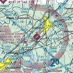
| Sectional chart |
|---|
|
CAUTION: Diagram may not be current

| Airport distance calculator |
|---|
|
|
| Sunrise and sunset |
|---|
|
Times for 03-Jun-2026
| | Local
(UTC-4) | | Zulu
(UTC) |
|---|
| Morning civil twilight | | 05:37 | | 09:37 |
| Sunrise | | 06:07 | | 10:07 |
| Sunset | | 20:32 | | 00:32 |
| Evening civil twilight | | 21:02 | | 01:02 |
|
| Current date and time |
|---|
| Zulu (UTC) | 03-Jun-2026 07:50:33 |
|---|
| Local (UTC-4) | 03-Jun-2026 03:50:33 |
|---|
|
| METAR |
|---|
| KEXX | 030735Z AUTO 00000KT 10SM CLR 10/10 A3028 RMK AO2 T01040104
|
KRUQ
13nm SW | 030730Z AUTO 00000KT 10SM CLR 10/09 A3028 RMK AO2 T00980092
|
|
| TAF |
|---|
KINT
22nm N | 030529Z 0306/0406 03005KT P6SM SKC FM031600 03008G16KT P6SM SKC AMD NOT SKED
|
KGSO
26nm NE | 030529Z 0306/0406 03005KT P6SM SKC FM031600 03008G16KT P6SM SKC
|
|
| NOTAMs |
|---|
NOTAMs are issued by the DoD/FAA and will open in a separate window not controlled by AirNav.
|
|


