FAA INFORMATION EFFECTIVE 09 JULY 2026
Location
| FAA Identifier: | 8S2 |
| Lat/Long: | 47-30-53.1000N 120-29-04.8000W
47-30.885000N 120-29.080000W
47.5147500,-120.4846667
(estimated) |
| Elevation: | 857.6 ft. / 261.4 m (surveyed) |
| Variation: | 20E (1985) |
| From city: | 2 miles SW of CASHMERE, WA |
| Time zone: | UTC -7 (UTC -8 during Standard Time) |
| Zip code: | 98815 |
Airport Operations
| Airport use: | Open to the public |
| Activation date: | 07/1950 |
| Control tower: | no |
| ARTCC: | SEATTLE CENTER |
| FSS: | SEATTLE FLIGHT SERVICE STATION |
| NOTAMs facility: | SEA (NOTAM-D service available) |
| Attendance: | UNATNDD |
| Wind indicator: | lighted |
| Segmented circle: | no |
| Lights: | ACTVT MIRL RWY 07/25 - 121.7. |
| Beacon: | white-green (lighted land airport)
ACTVT BCN - 121.7. |
Airport Communications
| CTAF: | 122.9 |
| WX ASOS at EAT (13 nm SE): | 119.925 (509-886-4226) |
Nearby radio navigation aids
| VOR radial/distance | | VOR name | | Freq | | Var |
|---|
| EATr287/13.1 | | WENATCHEE VOR/DME | | 114.35 | | 15E |
| ELNr337/29.4 | | ELLENSBURG VOR/DME | | 117.90 | | 21E |
Airport Services
| Parking: | tiedowns |
| Airframe service: | NONE |
| Powerplant service: | NONE |
| Bottled oxygen: | NONE |
| Bulk oxygen: | NONE |
Runway Information
Runway 7/25
| Dimensions: | 1800 x 50 ft. / 549 x 15 m |
| Surface: | asphalt, in fair condition |
| Weight bearing capacity: | |
| Runway edge lights: | medium intensity |
| RUNWAY 7 | | RUNWAY 25 |
| Latitude: | 47-30.884237N | | 47-30.885113N |
| Longitude: | 120-29.297863W | | 120-28.860805W |
| Elevation: | 857.6 ft. | | 833.0 ft. |
| Traffic pattern: | left | | left |
| Runway heading: | 070 magnetic, 090 true | | 250 magnetic, 270 true |
| Displaced threshold: | no | | 144 ft. |
| Markings: | basic, in fair condition | | basic, in fair condition |
| Touchdown point: | yes, no lights | | yes, no lights |
| Obstructions: | 54 ft. trees, 318 ft. from runway, 107 ft. right of centerline, 2:1 slope to clear
RWY 07 +4 FT FENCE 100 FT L, FR 200-100 FT, ; +5 FT FENCE 109 FT R, FR 65-200 FT FR THR. | | 50 ft. trees, 524 ft. from runway, 21 ft. right of centerline, 6:1 slope to clear
+4 FT FENCE 90 FT, 40 FT L&R; ROAD AT 90 FT; 25-30 FT TREES AT 150 FT, 60 FT R; 3 FT SIGN AT 22 FT FM THR, 79 FT L. |
Airport Ownership and Management from official FAA records
| Ownership: | Publicly-owned |
| Owner: | CHELAN COUNTY
COURT HOUSE
WENATCHEE, WA 98801
Phone 509-665-6700 |
| Manager: | GINA SMITH
5500 AIRPORT ROAD
CASHMERE, WA 98815
Phone (509) 782-3321 |
Additional Remarks
| - | NUMEROUS OBJECTS IN TRANSITION SFCS. |
| - | TREES IN PRIM SFC RY 07. |
| - | EXIT RWY AT TWYS ONLY. |
| - | GROUND VEHICLES AND PEDESTRIANS USE TWY FOR HANGAR ACCESS. |
| - | RADIO CONTROL MODEL ACTIVITY PERMITTED, ON WEST END OF ARPT. |
| - | FOR CD CTC SEATTLE ARTCC AT 253-351-3694. |
Instrument Procedures
There are no published instrument procedures at 8S2.
Some nearby airports with instrument procedures:
KEAT - Pangborn Memorial Airport (13 nm SE)
KELN - Bowers Field Airport (29 nm S)
KEPH - Ephrata Municipal Airport (41 nm E)
KMWH - Grant County International Airport (51 nm E)
KYKM - Yakima Air Terminal/McAllister Field (57 nm S)
|
|

Road maps at:
MapQuest
Bing
Google
| Aerial photo |
|---|
WARNING: Photo may not be current or correct
 Photo by Steven Wise
Photo taken 02-Jun-2007
Photo by Steven Wise
Photo taken 02-Jun-2007
Do you have a better or more recent aerial photo of Cashmere-Dryden Airport that you would like to share? If so, please send us your photo.
|
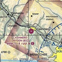
| Sectional chart |
|---|
|
| Airport distance calculator |
|---|
|
|
| Sunrise and sunset |
|---|
|
Times for 01-Aug-2026
| | Local
(UTC-7) | | Zulu
(UTC) |
|---|
| Morning civil twilight | | 05:05 | | 12:05 |
| Sunrise | | 05:41 | | 12:41 |
| Sunset | | 20:36 | | 03:36 |
| Evening civil twilight | | 21:12 | | 04:12 |
|
| Current date and time |
|---|
| Zulu (UTC) | 01-Aug-2026 11:45:37 |
|---|
| Local (UTC-7) | 01-Aug-2026 04:45:37 |
|---|
|
| METAR |
|---|
KEAT
13nm SE | 011055Z AUTO 32013KT 10SM CLR 23/09 A2990 RMK AO2 SLP115 T02330089
|
|
| TAF |
|---|
KEAT
13nm SE | 010539Z 0106/0206 08009KT P6SM SKC FM011000 31011KT P6SM SKC FM011500 30012G25KT P6SM FEW250 FM012000 29022G34KT 6SM HZ SKC FM020400 30019G27KT P6SM FEW250
|
|
| NOTAMs |
|---|
NOTAMs are issued by the DoD/FAA and will open in a separate window not controlled by AirNav.
|
|

