FAA INFORMATION EFFECTIVE 16 APRIL 2026
Location
| FAA Identifier: | 9G2 |
| Lat/Long: | 42-48-27.4000N 083-46-08.3000W
42-48.456667N 083-46.138333W
42.8076111,-83.7689722
(estimated) |
| Elevation: | 919.4 ft. / 280 m (estimated) |
| Variation: | 06W (2000) |
| From city: | 1 mile S of LINDEN, MI |
| Time zone: | UTC -4 (UTC -5 during Standard Time) |
| Zip code: | 48451 |
Airport Operations
| Airport use: | Open to the public |
| Activation date: | 02/1967 |
| Control tower: | no |
| ARTCC: | CLEVELAND CENTER |
| FSS: | LANSING FLIGHT SERVICE STATION |
| NOTAMs facility: | LAN (NOTAM-D service available) |
| Attendance: | IREG |
| Wind indicator: | lighted |
| Segmented circle: | no |
| Lights: | ACTVT MIRL RWY 09/27 - CTAF. |
| Beacon: | white-green (lighted land airport)
Operates sunset to sunrise. |
Airport Communications
| CTAF/UNICOM: | 123.0 |
| GREAT LAKES APPROACH: | 128.55 |
| GREAT LAKES DEPARTURE: | 128.55 |
| WX ASOS at FNT (10 nm N): | PHONE 810-202-2914 |
| WX AWOS-3P at OZW (14 nm SW): | 118.875 (517-546-4450) |
| WX ASOS at PTK (18 nm SE): | 125.025 (248-886-8551) |
| WX AWOS-3P at RNP (20 nm NW): | 118.025 (989-729-2967) |
- APCH/DEP SVC PRVDD BY CLEVELAND ARTCC (ZOB) ON FREQS 126.75/348.75 (FLINT RCAG) WHEN GREAT LAKES APCH CTL CLSD.
Nearby radio navigation aids
| VOR radial/distance | | VOR name | | Freq | | Var |
|---|
| FNTr192/9.6 | | FLINT VORTAC | | 116.90 | | 06W |
| SVMr345/25.2 | | SALEM VORTAC | | 114.30 | | 03W |
| DXOr339/39.9 | | DETROIT VOR/DME | | 113.40 | | 06W |
Airport Services
| Fuel available: | 100LL |
| Parking: | hangars and tiedowns |
| Airframe service: | MAJOR
PRIOR ARNGMT. |
| Powerplant service: | MAJOR |
Runway Information
Runway 9/27
| Dimensions: | 3999 x 75 ft. / 1219 x 23 m |
| Surface: | asphalt, in fair condition |
| Runway edge lights: | medium intensity |
| RUNWAY 9 | | RUNWAY 27 |
| Latitude: | 42-48.453502N | | 42-48.461403N |
| Longitude: | 083-46.584937W | | 083-45.690863W |
| Elevation: | 919.4 ft. | | 905.7 ft. |
| Traffic pattern: | left | | left |
| Runway heading: | 095 magnetic, 089 true | | 275 magnetic, 269 true |
| Displaced threshold: | 267 ft. | | 800 ft. |
| Markings: | nonprecision, in fair condition | | nonprecision, in fair condition |
| Runway end identifier lights: | no | | no |
| Touchdown point: | yes, no lights | | yes, no lights |
| Obstructions: | 36 ft. trees, 200 ft. from runway, 250 ft. right of centerline
-7 FT POND, 140 FT DIST. | | 36 ft. trees, 356 ft. from runway, 133 ft. left of centerline, 4:1 slope to clear
APCH RATIO 20:1 TO DTHR. |
Airport Ownership and Management from official FAA records
| Ownership: | Privately-owned |
| Owner: | 9G2 LLC
15057 LINDBERGH CT
LINDEN, MI 48451-9054
Phone 586-946-5381 |
| Manager: | JASON MORFORD
15057 LINDBERGH CT
LINDEN, MI 48451-9054
Phone 810-444-3458 |
Additional Remarks
| - | DEER & LRG BIRDS ON & INVOF ARPT. |
| - | FOR CD CTC GREAT LAKES APCH AT 269-459-3345, WHEN APCH CLSD CTC CLEVELAND ARTCC AT 440-774-0229/0490. |
Instrument Procedures
NOTE: All procedures below are presented as PDF files. If you need a reader for these files, you should download the free Adobe Reader.NOT FOR NAVIGATION. Please procure official charts for flight.
FAA instrument procedures published for use from 16 April 2026 at 0901Z to 14 May 2026 at 0900Z.
IAPs - Instrument Approach Procedures |
|---|
| RNAV (GPS) RWY 09 **CHANGED** | |
download (176KB) |
| RNAV (GPS) RWY 27 **CHANGED** | |
download (180KB) |
| VOR-A **CHANGED** | |
download (149KB) |
| NOTE: Special Take-Off Minimums/Departure Procedures apply | |
download (184KB) |
Other nearby airports with instrument procedures:
KFNT - Bishop International Airport (10 nm N)
KOZW - Livingston County/Spencer J Hardy Airport (14 nm SW)
KPTK - Oakland County International Airport (18 nm SE)
Y47 - Oakland Southwest Airport (19 nm S)
KRNP - Owosso Community Airport (20 nm NW)
|
|

Road maps at:
MapQuest
Bing
Google
| Aerial photo |
|---|
WARNING: Photo may not be current or correct

Do you have a better or more recent aerial photo of Price's Airport that you would like to share? If so, please send us your photo.
|
| Sectional chart |
|---|
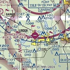
|
| Airport distance calculator |
|---|
|
|
| Sunrise and sunset |
|---|
|
Times for 29-Apr-2026
| | Local
(UTC-4) | | Zulu
(UTC) |
|---|
| Morning civil twilight | | 06:02 | | 10:02 |
| Sunrise | | 06:33 | | 10:33 |
| Sunset | | 20:32 | | 00:32 |
| Evening civil twilight | | 21:03 | | 01:03 |
|
| Current date and time |
|---|
| Zulu (UTC) | 29-Apr-2026 10:21:28 |
|---|
| Local (UTC-4) | 29-Apr-2026 06:21:28 |
|---|
|
| METAR |
|---|
KFNT
10nm N | 290953Z AUTO 05007KT 10SM BKN080 OVC100 10/05 A2989 RMK AO2 SLP122 T01000050 $
|
KOZW
14nm SW | 290955Z AUTO 06006KT 10SM -RA BKN042 BKN060 OVC080 09/04 A2988 RMK AO2
|
KPTK
18nm SE | 290953Z 05007KT 9SM SCT042 BKN080 OVC100 09/04 A2987 RMK SLPNO T00900040
|
KRNP
20nm NW | 290955Z AUTO 09006KT 10SM -DZ SCT060 BKN070 OVC075 09/04 A2989 RMK AO2 T00930043
|
|
| TAF |
|---|
KFNT
10nm N | 290523Z 2906/3006 36007KT P6SM BKN040 BKN250 FM290800 03007KT P6SM BKN040 BKN100 OVC250 FM291100 06010KT P6SM SCT025 BKN040 OVC080 TEMPO 2911/2915 6SM -SHRA BKN025 OVC040 FM291600 03010KT P6SM BKN040 OVC100 FM300100 36005KT P6SM SCT025 OVC040
|
KPTK
18nm SE | 290523Z 2906/3006 36007KT P6SM BKN040 BKN250 FM290800 03007KT P6SM BKN040 BKN100 OVC250 FM291100 06010KT P6SM SCT025 BKN040 OVC080 TEMPO 2911/2915 6SM -SHRA BKN025 OVC040 FM291600 03010KT P6SM BKN040 OVC100 FM300100 33005KT P6SM SCT025 OVC040
|
|
| NOTAMs |
|---|
NOTAMs are issued by the DoD/FAA and will open in a separate window not controlled by AirNav.
|
|

