FAA INFORMATION EFFECTIVE 09 JULY 2026
Location
| FAA Identifier: | ALW |
| Lat/Long: | 46-05-33.1500N 118-17-02.6970W
46-05.552500N 118-17.044950W
46.0925417,-118.2840825
(estimated) |
| Elevation: | 1194.4 ft. / 364.1 m (surveyed) |
| Variation: | 14E (2025) |
| From city: | 3 miles NE of WALLA WALLA, WA |
| Time zone: | UTC -7 (UTC -8 during Standard Time) |
| Zip code: | 99362 |
Airport Operations
| Airport use: | Open to the public |
| Activation date: | 10/1937 |
| Control tower: | yes |
| ARTCC: | SEATTLE CENTER |
| FSS: | SEATTLE FLIGHT SERVICE STATION |
| NOTAMs facility: | ALW (NOTAM-D service available) |
| Attendance: | 0800-1800 |
| Wind indicator: | lighted |
| Segmented circle: | no |
| Lights: | WHEN ATCT CLSD ACTVT MALSR RY 20, REIL RY 02 & HIRL RY 02/20 - CTAF. |
| Beacon: | white-green (lighted land airport)
Operates sunset to sunrise. |
| Fire and rescue: | ARFF index A |
| Airline operations: | ARFF SVCS AVBL DURING SCHEDULED ACR OPS. CLSD TO UNSKED ACR OPNS WITH MORE THAN 30 PSGR SEATS EXCP PPR CALL AMGR 509-525-3100. |
Airport Communications
| CTAF: | 118.5 |
| UNICOM: | 122.95 |
| WX ASOS: | 135.875 (509-525-3014) |
| WALLA WALLA GROUND: | 121.6 289.4 [0600-1830] |
| WALLA WALLA TOWER: | 118.5 289.4 [0600-1830] |
| SPOKANE APPROACH: | 133.15 |
| SPOKANE DEPARTURE: | 133.15 |
- FREQ 121.5 NOT AVBL.
- APCH/DEP CTL SVC PROVDD BY SEATTLE ARTCC (ZSE) ON 132.6/269.35 (YAKIMA RCAG), WHEN GEG APCH CLSD.
Nearby radio navigation aids
| VOR radial/distance | | VOR name | | Freq | | Var |
|---|
| ALW at field | | WALLA WALLA VOR/DME | | 116.40 | | 14E |
| PDTr035/36.1 | | PENDLETON VORTAC | | 114.70 | | 14E |
| PSCr092/36.2 | | PASCO VOR/DME | | 113.75 | | 15E |
| NDB name | | Hdg/Dist | | Freq | | Var | | ID |
|---|
| TRINA | | 202/6.2 | | 353 | | 14E | | AL | .- .-.. |
Airport Services
| Fuel available: | 100LL JET-A
100LL:SELF SVC CREDIT CARD FUELING FACILITY LCTD 600 FT N OF ATCT. |
| Parking: | hangars and tiedowns |
| Airframe service: | MAJOR |
| Powerplant service: | MAJOR |
| Bulk oxygen: | LOW |
Runway Information
Runway 2/20
| Dimensions: | 6527 x 150 ft. / 1989 x 46 m |
| Surface: | concrete/grooved, in good condition |
| Weight bearing capacity: | | Single wheel: | 84.0 | | Double wheel: | 107.0 | | Double tandem: | 164.0 |
|
| Runway edge lights: | high intensity |
| RUNWAY 2 | | RUNWAY 20 |
| Latitude: | 46-05.119267N | | 46-05.985970N |
| Longitude: | 118-17.500550W | | 118-16.589362W |
| Elevation: | 1153.9 ft. | | 1194.4 ft. |
| Traffic pattern: | left | | left |
| Runway heading: | 022 magnetic, 036 true | | 202 magnetic, 216 true |
| Declared distances: | TORA:6527 TODA:6527 ASDA:6527 LDA:6527 | | TORA:6527 TODA:6527 ASDA:6527 LDA:6527 |
| Markings: | nonprecision, in good condition | | precision, in good condition |
| Visual slope indicator: | 4-light PAPI on left (3.00 degrees glide path) | | 4-light PAPI on left (3.00 degrees glide path) |
| RVR equipment: | rollout | | touchdown |
| Approach lights: | | | MALSR: 1,400 foot medium intensity approach lighting system with runway alignment indicator lights |
| Runway end identifier lights: | yes | | |
| Touchdown point: | yes, no lights | | yes, no lights |
| Instrument approach: | | | ILS |
Airport Ownership and Management from official FAA records
| Ownership: | Publicly-owned |
| Owner: | PORT OF WALLA WALLA
45 TERMINAL LOOP RD., SUITE 210
WALLA WALLA, WA 99362
Phone 509-525-3100 |
| Manager: | JENNIFER SKOGLUND
45 TERMINAL LOOP RD., SUITE 210
WALLA WALLA, WA 99362
Phone 509-525-3100 |
Additional Remarks
| A39-02/20 | PCR VALUE: 340/F/D/X/T |
| - | SFC CONDS UNMON 0000-0300. |
| - | TWY A,A1,A2,A3,A4,A5 OPEN TO AIR CARRIERS. |
| - | 24 HR FUEL SVC CALL 509-540-1081. |
| - | PTN OF CORNER AT TWY A & TWY A1 NOT VSB BY TWR. |
| - | FOR CD WHEN ALW ATC IS CLSD CTC SPOKANE APCH AT 509-742-2525. WHEN APCH CLSD CTC SEATTLE ARTCC AT 253-351-3694 |
| - | CTC AMGR 509-525-3100 FOR ARNGMT FOR RAMP PRKG OF 175,000 LB MTOW |
Instrument Procedures
NOTE: All procedures below are presented as PDF files. If you need a reader for these files, you should download the free Adobe Reader.NOT FOR NAVIGATION. Please procure official charts for flight.
FAA instrument procedures published for use from 09 July 2026 at 0901Z to 06 August 2026 at 0900Z.
IAPs - Instrument Approach Procedures |
|---|
| ILS OR LOC RWY 20 | |
download (375KB) |
| RNAV (GPS) RWY 02 | |
download (375KB) |
| RNAV (GPS) RWY 20 | |
download (367KB) |
| VOR RWY 02 | |
download (326KB) |
| VOR RWY 20 | |
download (378KB) |
| NOTE: Special Alternate Minimums apply | |
download (209KB) |
Departure Procedures |
|---|
| WALLA WALLA TWO | |
download (164KB) |
| NOTE: Special Take-Off Minimums/Departure Procedures apply | |
download (543KB) |
Other nearby airports with instrument procedures:
KPDT - Eastern Oregon Regional Airport at Pendleton (33 nm SW)
KPSC - Tri-Cities Airport (36 nm W)
KHRI - Hermiston Municipal Airport (44 nm W)
KRLD - Richland Airport (44 nm W)
KLGD - La Grande/Union County Airport (50 nm S)
|
|

Road maps at:
MapQuest
Bing
Google
| Aerial photo |
|---|
WARNING: Photo may not be current or correct
 Photo by Bryan J. Painter
Photo taken 18-May-2008
from 14,000 ft
Photo by Bryan J. Painter
Photo taken 18-May-2008
from 14,000 ft
Do you have a better or more recent aerial photo of Walla Walla Regional Airport that you would like to share? If so, please send us your photo.
|
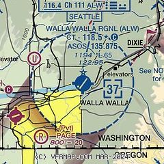
| Sectional chart |
|---|
|
CAUTION: Diagram may not be current
 Download PDF
of official airport diagram from the FAA
| Airport distance calculator |
|---|
|
|
| Sunrise and sunset |
|---|
|
Times for 30-Jul-2026
| | Local
(UTC-7) | | Zulu
(UTC) |
|---|
| Morning civil twilight | | 04:59 | | 11:59 |
| Sunrise | | 05:34 | | 12:34 |
| Sunset | | 20:25 | | 03:25 |
| Evening civil twilight | | 21:00 | | 04:00 |
|
| Current date and time |
|---|
| Zulu (UTC) | 30-Jul-2026 23:12:12 |
|---|
| Local (UTC-7) | 30-Jul-2026 16:12:12 |
|---|
|
| METAR |
|---|
| KALW | 302253Z 26006KT 9SM CLR 31/06 A2994 RMK AO2 SLP131 T03110056
|
|
| TAF |
|---|
| KALW | 301727Z 3018/3118 24007KT P6SM SKC FM310400 14007KT P6SM BKN250 FM311200 18005KT P6SM SKC
|
|
| NOTAMs |
|---|
NOTAMs are issued by the DoD/FAA and will open in a separate window not controlled by AirNav.
|
|


