FAA INFORMATION EFFECTIVE 14 MAY 2026
Location
| FAA Identifier: | APV |
| Lat/Long: | 34-34-31.1930N 117-11-10.2770W
34-34.519883N 117-11.171283W
34.5753314,-117.1861881
(estimated) |
| Elevation: | 3061.5 ft. / 933.1 m (surveyed) |
| Variation: | 14E (2000) |
| From city: | 3 miles N of APPLE VALLEY, CA |
| Time zone: | UTC -7 (UTC -8 during Standard Time) |
| Zip code: | 92307 |
Airport Operations
| Airport use: | Open to the public |
| Activation date: | 02/1970 |
| Control tower: | no |
| ARTCC: | LOS ANGELES CENTER |
| FSS: | RIVERSIDE FLIGHT SERVICE STATION |
| NOTAMs facility: | RAL (NOTAM-D service available) |
| Attendance: | 0800-1700 |
| Pattern altitude: | TPA RWY 18/36 1000 FT AGL; RWY 08/26 800 FT AGL. |
| Wind indicator: | lighted |
| Segmented circle: | yes |
| Lights: | ACTVT MIRL RWY 18/36 & TWY LGTS SS-SR - CTAF. PAPI RWY 18 & 36 ON CONSLY. |
| Beacon: | white-green (lighted land airport)
Operates sunset to sunrise. |
Airport Communications
| CTAF/UNICOM: | 122.8 |
| JOSHUA APPROACH: | 124.55 |
| JOSHUA DEPARTURE: | 124.55 |
| WX AWOS-3 at VCV (10 nm W): | 135.475 (760-246-3635) |
- AUTOMATED UNICOM; 3 CLICKS ADZY, 4 CLICKS RADIO CHECK.
- COMMUNICATIONS PRVDD BY RIVERSIDE RADIO ON FREQ 122.3 (BARSTOW RCO).
Nearby radio navigation aids
| VOR radial/distance | | VOR name | | Freq | | Var |
|---|
| VCVr082/10.1 | | VICTORVILLE VOR/DME | | 109.05 | | 14E |
| EDWr120/36.4 | | EDWARDS VORTAC | | 116.40 | | 12E |
| DAGr217/37.9 | | DAGGETT VORTAC | | 113.20 | | 15E |
| HECr235/38.1 | | HECTOR VORTAC | | 112.70 | | 15E |
| RALr005/(39.4) | | RIVERSIDE VOR | | 108.60 | | 14E |
Airport Services
| Fuel available: | 100LL JET-A
100LL:SS FUEL AVBL 24 HRS CALL 760-617-7599. |
| Parking: | tiedowns |
| Airframe service: | MAJOR |
| Powerplant service: | MAJOR |
| Bottled oxygen: | NONE |
| Bulk oxygen: | NONE |
Runway Information
Runway 18/36
| Dimensions: | 6498 x 150 ft. / 1981 x 46 m |
| Surface: | asphalt, in fair condition |
| Weight bearing capacity: | | Single wheel: | 70.0 | | Double wheel: | 90.0 | | Double tandem: | 150.0 |
|
| Runway edge lights: | medium intensity |
| RUNWAY 18 | | RUNWAY 36 |
| Latitude: | 34-35.252910N | | 34-34.223795N |
| Longitude: | 117-10.952805W | | 117-11.311420W |
| Elevation: | 3061.5 ft. | | 2966.0 ft. |
| Traffic pattern: | left | | right |
| Runway heading: | 182 magnetic, 196 true | | 002 magnetic, 016 true |
| Displaced threshold: | no | | 597 ft. |
| Markings: | nonprecision, in fair condition | | basic, in good condition |
| Visual slope indicator: | 2-light PAPI on left (3.50 degrees glide path) | | 2-light PAPI on left (3.00 degrees glide path) |
| Runway end identifier lights: | no | | no |
| Touchdown point: | yes, no lights | | yes, no lights |
| Obstructions: | 10 ft. hill, 500 ft. from runway, 125 ft. right of centerline, 30:1 slope to clear | | none |
Runway 8/26
| Dimensions: | 4100 x 60 ft. / 1250 x 18 m |
| Surface: | asphalt, in poor condition
LRG CRACKS, RAVELING. |
| Weight bearing capacity: | | Single wheel: | 40.0 | | Double wheel: | 60.0 | | Double tandem: | 100.0 |
|
| Runway edge markings: | MARKINGS FADED, CTRLN MISG. |
| Operational restrictions: | RWY 08/26 CLSD TO NIGHT OPNS DUE TO RAPIDLY RISING TERRAIN EAST AND WEST OF RY; WEST TO 3890 FT WITHIN 1.5 NM AND EAST TO 3910 FT WITHIN 1.7 NM. |
| RUNWAY 8 | | RUNWAY 26 |
| Latitude: | 34-34.173588N | | 34-34.173658N |
| Longitude: | 117-11.641793W | | 117-10.824843W |
| Elevation: | 2957.7 ft. | | 2975.5 ft. |
| Traffic pattern: | right | | left |
| Runway heading: | 076 magnetic, 090 true | | 256 magnetic, 270 true |
| Markings: | basic, in poor condition | | basic, in good condition |
| Touchdown point: | yes, no lights | | yes, no lights |
| Obstructions: | 40 ft. pline, 1540 ft. from runway, 212 ft. left of centerline, 34:1 slope to clear | | none |
Airport Ownership and Management from official FAA records
| Ownership: | Publicly-owned |
| Owner: | COUNTY OF SAN BERNARDINO
268 HOSPITALITY LANE, SUITE 302
SAN BERNARDINO, CA 92415
Phone 909-387-8810 |
| Manager: | TESS COOK
21600 CORWIN ROAD
APPLE VALLEY, CA 92307
Phone 909-327-8740 |
Additional Remarks
| - | HILLS NE; E; W AND N. |
| - | RY 18/36 LGTD DSTC REMAINING MKRS EAST SIDE OF RY. |
| - | ON APCH TO RY 36 CROSS RY 08/26. |
| - | RY 08/26 CLSD TO ACFT OVER 12500 LBS WITHOUT PPR FM AMGR CALL (760) 247-2371. |
| - | AEROBATIC TRAINING NE AREA OF ARPT. |
Instrument Procedures
NOTE: All procedures below are presented as PDF files. If you need a reader for these files, you should download the free Adobe Reader.NOT FOR NAVIGATION. Please procure official charts for flight.
FAA instrument procedures published for use from 14 May 2026 at 0901Z to 11 June 2026 at 0900Z.
IAPs - Instrument Approach Procedures |
|---|
| RNAV (GPS) RWY 18 | |
download (251KB) |
|
|---|
| EXCON ONE (OBSTACLE) (RNAV) | |
download (133KB) |
| NOTE: Special Take-Off Minimums/Departure Procedures apply | |
download (211KB) |
Other nearby airports with instrument procedures:
KVCV - Southern California Logistics Airport (10 nm W)
L35 - Big Bear City Airport (25 nm SE)
KDAG - Barstow-Daggett Airport (26 nm NE)
KSBD - San Bernardino International Airport (29 nm S)
KREI - Redlands Municipal Airport (29 nm S)
|
|

Road maps at:
MapQuest
Bing
Google
| Aerial photo |
|---|
WARNING: Photo may not be current or correct
 Photo courtesy of focalflight.com
Photo taken 13-Aug-2017
looking southeast.
Photo courtesy of focalflight.com
Photo taken 13-Aug-2017
looking southeast.
Do you have a better or more recent aerial photo of Apple Valley Airport that you would like to share? If so, please send us your photo.
|
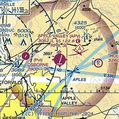
| Sectional chart |
|---|
|
| Airport distance calculator |
|---|
|
|
| Sunrise and sunset |
|---|
|
Times for 15-May-2026
| | Local
(UTC-7) | | Zulu
(UTC) |
|---|
| Morning civil twilight | | 05:19 | | 12:19 |
| Sunrise | | 05:47 | | 12:47 |
| Sunset | | 19:43 | | 02:43 |
| Evening civil twilight | | 20:11 | | 03:11 |
|
| Current date and time |
|---|
| Zulu (UTC) | 15-May-2026 18:34:14 |
|---|
| Local (UTC-7) | 15-May-2026 11:34:14 |
|---|
|
| METAR |
|---|
KVCV
10nm W | 151815Z AUTO VRB06G13KT 10SM CLR 28/00 A2995 RMK AO2
|
|
| TAF |
|---|
KDAG
26nm NE | 151726Z 1518/1618 29011G19KT P6SM SKC FM152300 24022G30KT P6SM SKC FM161500 25025G35KT P6SM SKC
|
KSBD
29nm S | 151720Z 1518/1618 VRB05KT 5SM HZ OVC016 FM152200 25010KT P6SM SKC FM160400 VRB05KT P6SM SKC FM160900 VRB04KT 5SM HZ BKN015
|
|
| NOTAMs |
|---|
NOTAMs are issued by the DoD/FAA and will open in a separate window not controlled by AirNav.
|
|


