FAA INFORMATION EFFECTIVE 02 OCTOBER 2025
Location
| FAA Identifier: | ASL |
| Lat/Long: | 32-31-13.8000N 094-18-28.0000W
32-31.230000N 094-18.466667W
32.5205000,-94.3077778
(estimated) |
| Elevation: | 357 ft. / 108.8 m (surveyed) |
| Variation: | 03E (2010) |
| From city: | 3 miles SE of MARSHALL, TX |
| Time zone: | UTC -5 (UTC -6 during Standard Time) |
| Zip code: | 75672 |
Airport Operations
| Airport use: | Open to the public |
| Activation date: | 11/1937 |
| Control tower: | no |
| ARTCC: | FORT WORTH CENTER |
| FSS: | FORT WORTH FLIGHT SERVICE STATION |
| NOTAMs facility: | FTW (NOTAM-D service available) |
| Attendance: | MON-SAT 0800-1700, ALL SUN IREG
FOR ARPT ATTENDANT ON SUN CALL 903-938-1394. |
| Wind indicator: | lighted |
| Segmented circle: | yes |
| Lights: | MIRL RWY 15/33 PRESET LOW INTST; TO INCR INTST & ACTVT REIL RWY 15 & 33 - CTAF. |
| Beacon: | white-green (lighted land airport)
Operates sunset to sunrise. |
Airport Communications
| CTAF/UNICOM: | 122.8 |
| WX AWOS-3PT: | 118.675 (903-938-2060) |
| SHREVEPORT APPROACH: | 119.9 |
| SHREVEPORT DEPARTURE: | 119.9 |
Nearby radio navigation aids
| VOR radial/distance | | VOR name | | Freq | | Var |
|---|
| GGGr068/23.4 | | GREGG COUNTY VORTAC | | 112.90 | | 07E |
| EICr232/29.3 | | BELCHER VORTAC | | 117.40 | | 07E |
| EMGr274/36.8 | | ELM GROVE VORTAC | | 116.65 | | 07E |
| NDB name | | Hdg/Dist | | Freq | | Var | | ID |
|---|
| ATLANTA | | 186/35.5 | | 347 | | 04E | | ATA | .- - .- |
Airport Services
| Fuel available: | 100LL JET-A |
| Parking: | hangars and tiedowns |
| Airframe service: | MAJOR |
| Powerplant service: | MAJOR |
| Bottled oxygen: | HIGH/LOW |
| Bulk oxygen: | HIGH/LOW |
Runway Information
Runway 15/33
| Dimensions: | 5002 x 100 ft. / 1525 x 30 m |
| Surface: | asphalt, in excellent condition |
| Weight bearing capacity: | |
| Runway edge lights: | medium intensity |
| RUNWAY 15 | | RUNWAY 33 |
| Latitude: | 32-31.554123N | | 32-30.796485N |
| Longitude: | 094-18.657650W | | 094-18.272652W |
| Elevation: | 355.9 ft. | | 319.5 ft. |
| Traffic pattern: | left | | left |
| Runway heading: | 154 magnetic, 157 true | | 334 magnetic, 337 true |
| Markings: | nonprecision, in good condition | | nonprecision, in good condition |
| Runway end identifier lights: | yes | | yes |
| Touchdown point: | yes, no lights | | yes, no lights |
| Obstructions: | 7 ft. fence, 228 ft. from runway, 250 ft. left of centerline, 4:1 slope to clear | | 45 ft. trees, 900 ft. from runway, 315 ft. left of centerline, 15:1 slope to clear |
Runway 2/20
| Dimensions: | 3299 x 60 ft. / 1006 x 18 m |
| Surface: | asphalt, in good condition |
| Weight bearing capacity: | |
| RUNWAY 2 | | RUNWAY 20 |
| Latitude: | 32-31.059217N | | 32-31.564610N |
| Longitude: | 094-18.587082W | | 094-18.349505W |
| Elevation: | 338.3 ft. | | 341.1 ft. |
| Traffic pattern: | left | | left |
| Runway heading: | 019 magnetic, 022 true | | 199 magnetic, 202 true |
| Markings: | basic, in good condition | | basic, in good condition |
| Touchdown point: | yes, no lights | | yes, no lights |
| Obstructions: | 81 ft. trees, 1436 ft. from runway, 245 ft. left and right of centerline, 15:1 slope to clear | | 46 ft. trees, 397 ft. from runway, 155 ft. left and right of centerline, 4:1 slope to clear |
Airport Ownership and Management from official FAA records
| Ownership: | Publicly-owned |
| Owner: | HARRISON COUNTY
COUNTY COURTHOUSE
MARSHALL, TX 75670
Phone 903-935-8401 |
| Manager: | DANIEL AIELLO
2100 WARREN DR.
MARSHALL, TX 75672
Phone 903-938-1394
OR 903-938-8008. |
Additional Remarks
| - | FOR CD CTC FORT WORTH ARTCC AT 817-858-7584. |
Instrument Procedures
NOTE: All procedures below are presented as PDF files. If you need a reader for these files, you should download the free Adobe Reader.NOT FOR NAVIGATION. Please procure official charts for flight.
FAA instrument procedures published for use from 02 October 2025 at 0901Z to 30 October 2025 at 0900z.
IAPs - Instrument Approach Procedures |
|---|
| RNAV (GPS) RWY 15 | |
download (219KB) |
| RNAV (GPS) RWY 33 | |
download (236KB) |
| VOR/DME-A | |
download (184KB) |
| NOTE: Special Take-Off Minimums/Departure Procedures apply | |
download (113KB) |
Other nearby airports with instrument procedures:
4F2 - Panola County Airport-Sharpe Field (21 nm S)
KGGG - East Texas Regional Airport (22 nm W)
KSHV - Shreveport Regional Airport (25 nm E)
3F4 - Vivian Airport (25 nm NE)
KDTN - Shreveport Downtown Airport (29 nm E)
|
|

Road maps at:
MapQuest
Bing
Google
| Aerial photo |
|---|
WARNING: Photo may not be current or correct
 Photo by Carl Hennigan
Photo taken 07-Nov-2008
Photo by Carl Hennigan
Photo taken 07-Nov-2008
Do you have a better or more recent aerial photo of Harrison County Airport that you would like to share? If so, please send us your photo.
|
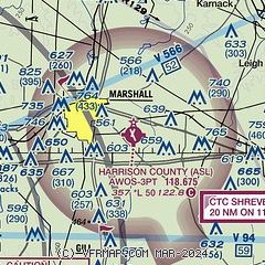
| Sectional chart |
|---|
|
CAUTION: Diagram may not be current

| Airport distance calculator |
|---|
|
|
| Sunrise and sunset |
|---|
|
Times for 22-Oct-2025
| | Local
(UTC-5) | | Zulu
(UTC) |
|---|
| Morning civil twilight | | 07:03 | | 12:03 |
| Sunrise | | 07:27 | | 12:27 |
| Sunset | | 18:36 | | 23:36 |
| Evening civil twilight | | 19:01 | | 00:01 |
|
| Current date and time |
|---|
| Zulu (UTC) | 22-Oct-2025 22:31:27 |
|---|
| Local (UTC-5) | 22-Oct-2025 17:31:27 |
|---|
|
| METAR |
|---|
| KASL | 222215Z AUTO VRB03KT 10SM CLR 26/03 A3009 RMK AO2 T02550034 $
|
|
| TAF |
|---|
KGGG
22nm W | 221720Z 2218/2318 12007KT P6SM FEW250 FM230000 14003KT P6SM SCT250 FM231200 VRB03KT P6SM BKN250
|
KSHV
24nm E | 221720Z 2218/2318 11006KT P6SM FEW250 FM230000 15003KT P6SM SCT250 FM231200 00000KT P6SM FEW250
|
|
| NOTAMs |
|---|
NOTAMs are issued by the DoD/FAA and will open in a separate window not controlled by AirNav.
|
|


