FAA INFORMATION EFFECTIVE 09 JULY 2026
Location
| FAA Identifier: | BCB |
| Lat/Long: | 37-12-33.7910N 080-24-43.5240W
37-12.563183N 080-24.725400W
37.2093864,-80.4120900
(estimated) |
| Elevation: | 2119.4 ft. / 646.0 m (surveyed) |
| Variation: | 08W (2020) |
| From city: | 3 miles S of BLACKSBURG, VA |
| Time zone: | UTC -4 (UTC -5 during Standard Time) |
| Zip code: | 24060 |
Airport Operations
| Airport use: | Open to the public |
| Activation date: | 08/1937 |
| Control tower: | no |
| ARTCC: | WASHINGTON CENTER |
| FSS: | LEESBURG FLIGHT SERVICE STATION |
| NOTAMs facility: | BCB (NOTAM-D service available) |
| Attendance: | 0800-1900
UNATNDD NEW YEARS DAY, THANKSGIVING DAY, CHRISTMAS DAY, MAJOR HOLS. |
| Pattern altitude: | TPA 1000 FT AGL FOR NON TURBINE POWERED ACFT. TPA FOR TURBINE POWERED ACFT 1500 FT AGL. |
| Wind indicator: | lighted |
| Segmented circle: | yes |
| Lights: | ACTVT ODALS RWY 13; REIL RWY 31; PAPI RWY 13 & 31; MIRL RWY 13/31 - CTAF. MIRL RWY 13/31 PRESET LOW INTST. |
| Beacon: | white-green (lighted land airport)
Operates sunset to sunrise. |
Airport Communications
| CTAF/UNICOM: | 123.05 |
| WX AWOS-3: | 133.325 (540-231-4837) |
| ROANOKE APPROACH: | 133.225 |
| ROANOKE DEPARTURE: | 133.225 |
| CLEARANCE DELIVERY: | 124.85 |
| IC: | 133.225 |
| WX AWOS-3 at PSK (13 nm W): | 127.375 (540-674-2731) |
Nearby radio navigation aids
| VOR radial/distance | | VOR name | | Freq | | Var |
|---|
| PSKr069/16.1 | | PULASKI VORTAC | | 116.80 | | 06W |
| BLFr102/37.8 | | BLUEFIELD VOR/DME | | 115.05 | | 03W |
| NDB name | | Hdg/Dist | | Freq | | Var | | ID |
|---|
| TECH | | at field | | 368 | | 08W | | TEC | - . -.-. |
| VINTON | | 279/25.4 | | 277 | | 08W | | VIT | ...- .. - |
Airport Services
| Fuel available: | 100LL JET-A+
100LL:PPR FOR FUEL WHEN ARPT UNATNDD; PHONE 540-231-4444; FEE FOR AFT HRS. |
| Parking: | tiedowns |
| Airframe service: | NONE |
| Powerplant service: | NONE |
| Bottled oxygen: | NONE |
| Bulk oxygen: | NONE |
Runway Information
Runway 13/31
| Dimensions: | 5501 x 100 ft. / 1677 x 30 m |
| Surface: | asphalt/grooved, in fair condition |
| Runway edge lights: | medium intensity |
| RUNWAY 13 | | RUNWAY 31 |
| Latitude: | 37-12.770175N | | 37-12.356167N |
| Longitude: | 080-25.229445W | | 080-24.221383W |
| Elevation: | 2119.1 ft. | | 2119.3 ft. |
| Traffic pattern: | left | | left |
| Runway heading: | 125 magnetic, 117 true | | 305 magnetic, 297 true |
| Markings: | nonprecision, in good condition | | nonprecision, in good condition |
| Visual slope indicator: | 4-light PAPI on left (3.44 degrees glide path) | | 2-light PAPI on left (3.00 degrees glide path) |
| Approach lights: | ODALS: omnidirectional approach lighting system | | |
| Runway end identifier lights: | no | | yes |
| Touchdown point: | yes, no lights | | yes, no lights |
| Instrument approach: | LOC/DME | | |
| Obstructions: | 59 ft. tree, 1112 ft. from runway, 363 ft. left of centerline, 15:1 slope to clear | | 48 ft. tree, 1341 ft. from runway, 395 ft. left of centerline, 23:1 slope to clear |
Airport Ownership and Management from official FAA records
| Ownership: | Publicly-owned |
| Owner: | VTMRAA
1601 RESEARCH CENTER DRIVE
BLACKSBURG, VA 24060
Phone 540-231-4444 |
| Manager: | KEITH HOLT
1601 RESEARCH CENTER DRIVE
BLACKSBURG, VA 24060
Phone 540-231-4444 |
Additional Remarks
| - | OCCASIONAL WILDLIFE ON ARPT. |
| - | VFR DEPARTURES MAINTAIN RWY HEADING UNTIL REACHING 1000 FT AGL. |
| - | NOISE SENSITIVE AREA NORTH OF ARPT. |
| - | ROA TWR SVCS AVBL AT 540-563-1307. |
| - | FOR CD CTC ROANOKE APCH AT 540-563-1307. |
Instrument Procedures
NOTE: All procedures below are presented as PDF files. If you need a reader for these files, you should download the free Adobe Reader.NOT FOR NAVIGATION. Please procure official charts for flight.
FAA instrument procedures published for use from 09 July 2026 at 0901Z to 06 August 2026 at 0900Z.
IAPs - Instrument Approach Procedures |
|---|
| RNAV (GPS) RWY 13 | |
download (228KB) |
| RNAV (GPS) RWY 31 | |
download (228KB) |
| LOC RWY 13 | |
download (234KB) |
| NOTE: Special Alternate Minimums apply | |
download (143KB) |
Departure Procedures |
|---|
| BEMAR THREE (RNAV) | |
download (136KB) |
| SETHY FIVE (RNAV) | |
download (189KB) |
| NOTE: Special Take-Off Minimums/Departure Procedures apply | |
download (357KB) |
Other nearby airports with instrument procedures:
KPSK - New River Valley Airport (13 nm W)
KROA - Roanoke-Blacksburg Regional Airport/Woodrum Field (22 nm E)
KHLX - Twin County Airport (33 nm SW)
KBLF - Mercer County Airport (38 nm W)
KLWB - Greenbrier Valley Airport (39 nm N)
|
|

Road maps at:
MapQuest
Bing
Google
| Aerial photo |
|---|
WARNING: Photo may not be current or correct
 Photo by William C Harris, Gladstone, NJ
Photo taken 31-Aug-2018
looking northwest.
Photo by William C Harris, Gladstone, NJ
Photo taken 31-Aug-2018
looking northwest.
Do you have a better or more recent aerial photo of Virginia Tech/Montgomery Executive Airport that you would like to share? If so, please send us your photo.
|
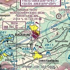
| Sectional chart |
|---|
|
| Airport distance calculator |
|---|
|
|
| Sunrise and sunset |
|---|
|
Times for 29-Jul-2026
| | Local
(UTC-4) | | Zulu
(UTC) |
|---|
| Morning civil twilight | | 05:56 | | 09:56 |
| Sunrise | | 06:25 | | 10:25 |
| Sunset | | 20:31 | | 00:31 |
| Evening civil twilight | | 21:00 | | 01:00 |
|
| Current date and time |
|---|
| Zulu (UTC) | 29-Jul-2026 07:35:44 |
|---|
| Local (UTC-4) | 29-Jul-2026 03:35:44 |
|---|
|
| METAR |
|---|
| KBCB | 290715Z AUTO 00000KT 10SM CLR 20/19 A2982 RMK AO2 T02010190
|
KPSK
13nm SW | 290715Z AUTO 34003KT 10SM SCT030 BKN038 BKN050 22/17 A2980 RMK AO2 T02150174
|
|
| TAF |
|---|
| KBCB | 290520Z 2906/3006 00000KT P6SM SCT050 FM290900 30003KT P6SM FEW030 FM291300 30008KT P6SM SKC FM291700 31011G21KT P6SM SCT100 FM300000 33004KT P6SM SKC
|
|
| NOTAMs |
|---|
NOTAMs are issued by the DoD/FAA and will open in a separate window not controlled by AirNav.
|
|

