FAA INFORMATION EFFECTIVE 19 MARCH 2026
Location
| FAA Identifier: | BFM |
| Lat/Long: | 30-37-36.4100N 088-04-05.1270W
30-37.606833N 088-04.085450W
30.6267806,-88.0680908
(estimated) |
| Elevation: | 26.2 ft. / 8.0 m (surveyed) |
| Variation: | 01W (2005) |
| From city: | 3 miles S of MOBILE, AL |
| Time zone: | UTC -5 (UTC -6 during Standard Time) |
| Zip code: | 36605 |
Airport Operations
| Airport use: | Open to the public |
| Activation date: | 04/1940 |
| Control tower: | yes |
| ARTCC: | HOUSTON CENTER |
| FSS: | ANNISTON FLIGHT SERVICE STATION |
| NOTAMs facility: | BFM (NOTAM-D service available) |
| Attendance: | 0700-2300 |
| Wind indicator: | lighted |
| Segmented circle: | yes |
| Lights: | DUSK-DAWN. WHEN ATCT CLSD ACTVT MALSR RWY 32 - CTAF. HIRL RWY 14/32 PRESET ON STEP 3 OR HYR BASED ON WX. |
| Beacon: | white-green (lighted land airport)
Operates sunset to sunrise. |
| Fire and rescue: | ARFF index B |
| International operations: | customs landing rights airport |
Airport Communications
| CTAF: | 118.8 |
| UNICOM: | 122.95 |
| ATIS: | 135.575 |
| WX ASOS: | PHONE 251-431-6762 |
| INTERNATIONAL GROUND: | 121.7 239.3 [0700-1900 SUN; 0700-2200 MON; 0330-2200 TUE THRU FRI; 0400-1900 SAT.] |
| INTERNATIONAL TOWER: | 118.8 251.1 [0700-1900 SUN; 0700-2200 MON; 0330-2200 TUE THRU FRI; 0400-1900 SAT.] |
| MOBILE APPROACH: | 118.5 |
| MOBILE DEPARTURE: | 118.5 |
| EMERG: | 121.5 |
| NG OPS: | 125.525 49.85FM |
| WX ASOS at MOB (10 nm NW): | 124.75 (251-206-0328) |
| WX AWOS-3PT at CQF (14 nm SE): | 118.425 (251-928-3242) |
| WX AWOS-3PT at 1R8 (19 nm NE): | 121.125 (251-580-5103) |
- APCH/DEP SVC PRVDD BY HOUSTON ARTCC (ZHU) ON FREQS 127.65/285.475 (MOBILE RCAG) WHEN APCH CTL CLSD.
- SAWRS 0800-1900.
Nearby radio navigation aids
| VOR radial/distance | | VOR name | | Freq | | Var |
|---|
| BFMr318/1.1 | | BROOKLEY VORTAC | | 116.35 | | 04E |
| SJIr107/16.2 | | SEMMES VORTAC | | 115.30 | | 05E |
| NUNr283/(39.0) | | SAUFLEY VOR | | 112.25 | | 01E |
| NDB name | | Hdg/Dist | | Freq | | Var | | ID |
|---|
| WISLE | | 125/14.5 | | 248 | | 01W | | MOB | -- --- -... |
Airport Services
| Fuel available: | 100LL JET-A |
| Parking: | hangars and tiedowns |
| Airframe service: | MAJOR |
| Powerplant service: | MAJOR |
| Bottled oxygen: | NONE |
| Bulk oxygen: | HIGH/LOW |
Runway Information
Runway 14/32
| Dimensions: | 9618 x 150 ft. / 2932 x 46 m |
| Surface: | asphalt/concrete/grooved, in good condition |
| Weight bearing capacity: | | PCN 72 /F/B/X/T | | Single wheel: | 75.0 | | Double wheel: | 185.0 | | Double tandem: | 325.0 |
|
| Runway edge lights: | high intensity |
| RUNWAY 14 | | RUNWAY 32 |
| Latitude: | 30-37.984702N | | 30-36.791895N |
| Longitude: | 088-04.796403W | | 088-03.586805W |
| Elevation: | 26.2 ft. | | 18.6 ft. |
| Traffic pattern: | right | | left |
| Runway heading: | 140 magnetic, 139 true | | 320 magnetic, 319 true |
| Markings: | precision, in good condition | | precision, in good condition |
| Visual slope indicator: | 4-light PAPI on left (3.00 degrees glide path) | | 4-light PAPI on left (3.00 degrees glide path) |
| RVR equipment: | rollout | | touchdown |
| Approach lights: | | | MALSR: 1,400 foot medium intensity approach lighting system with runway alignment indicator lights |
| Runway end identifier lights: | yes | | |
| Centerline lights: | yes
RWY 14/32 CNTRLN LGTS AVBL DURG ATCT OPER HRS ONLY. | | yes |
| Touchdown point: | yes, no lights | | yes, lighted
TDZ LGTS AVBL DURG ACTC OPER HRS ONLY. |
| Instrument approach: | | | ILS/DME |
| Obstructions: | 39 ft. tree, 1535 ft. from runway, 500 ft. right of centerline, 34:1 slope to clear | | none |
Runway 18/36
| Dimensions: | 7800 x 150 ft. / 2377 x 46 m |
| Surface: | asphalt/concrete, in fair condition |
| Weight bearing capacity: | | PCN 34 /R/B/X/T | | Single wheel: | 76.0 | | Double wheel: | 150.0 | | Double tandem: | 320.0 |
|
| Runway edge lights: | medium intensity |
| RUNWAY 18 | | RUNWAY 36 |
| Latitude: | 30-38.519615N | | 30-37.232895N |
| Longitude: | 088-03.955010W | | 088-03.954260W |
| Elevation: | 25.4 ft. | | 25.0 ft. |
| Traffic pattern: | left | | right |
| Runway heading: | 181 magnetic, 180 true | | 001 magnetic, 360 true |
| Markings: | nonprecision, in good condition | | nonprecision, in good condition |
| Visual slope indicator: | 4-light PAPI on left (3.00 degrees glide path) | | 4-light PAPI on left (3.00 degrees glide path) |
| Touchdown point: | yes, no lights | | yes, no lights |
| Obstructions: | 33 ft. pole, 1200 ft. from runway, 30:1 slope to clear | | 55 ft. trees, 1300 ft. from runway, 400 ft. left of centerline, 20:1 slope to clear |
Airport Ownership and Management from official FAA records
| Ownership: | Publicly-owned |
| Owner: | MOBILE AIRPORT AUTHORITY
1891-9TH ST/BROOKLEY COMPLEX
MOBILE, AL 36615
Phone 251-438-7334 |
| Manager: | ANDY WILSON
P O BOX 88004
MOBILE, AL 36608
Phone 251-639-4680
FAX PHONE 251-694-7667. |
Additional Remarks
| - | CONDS NOT MNT WHEN ATCT CLSD. |
| - | HOT CARGO SPACE ASGND TO TWY A BTN RWY 18/36 AND A6 |
| - | FOR CD WHEN ATCT CLSD CTC MOBILE APCH AT 251-662-6236. WHEN APCH CLSD CTC HOUSTON ARTCC AT 281-230-5622. |
| - | ARPT MNTN ARFF INDEX B. INDEX C AVBL UPON REQ. |
Instrument Procedures
NOTE: All procedures below are presented as PDF files. If you need a reader for these files, you should download the free Adobe Reader.NOT FOR NAVIGATION. Please procure official charts for flight.
FAA instrument procedures published for use from 19 March 2026 at 0901Z to 16 April 2026 at 0900Z.
IAPs - Instrument Approach Procedures |
|---|
| ILS OR LOC RWY 32 | |
download (316KB) |
| RNAV (GPS) RWY 14 | |
download (232KB) |
| RNAV (GPS) RWY 18 | |
download (242KB) |
| RNAV (GPS) RWY 32 | |
download (258KB) |
| RNAV (GPS) RWY 36 | |
download (247KB) |
| VOR RWY 14 | |
download (259KB) |
| VOR RWY 18 | |
download (255KB) |
| VOR RWY 32 | |
download (238KB) |
| NOTE: Special Alternate Minimums apply | |
download (158KB) |
| NOTE: Special Take-Off Minimums/Departure Procedures apply | |
download (500KB) |
Other nearby airports with instrument procedures:
KMOB - Mobile Regional Airport (10 nm NW)
2R5 - St Elmo Airport (13 nm SW)
KCQF - H L Sonny Callahan Airport (14 nm SE)
1R8 - Bay Minette Municipal Airport (19 nm NE)
5R4 - Holk Field at Foley Municipal Airport (22 nm SE)
|
|

Road maps at:
MapQuest
Bing
Google
| Aerial photo |
|---|
WARNING: Photo may not be current or correct
 Photo by Jim Van Buskirk
Photo taken 18-Jun-2020
looking west.
Photo by Jim Van Buskirk
Photo taken 18-Jun-2020
looking west.
Do you have a better or more recent aerial photo of Mobile International Airport that you would like to share? If so, please send us your photo.
|
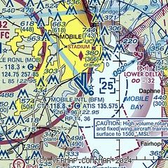
| Sectional chart |
|---|
|
 Download PDF
of official airport diagram from the FAA
| Airport distance calculator |
|---|
|
|
| Sunrise and sunset |
|---|
|
Times for 22-Mar-2026
| | Local
(UTC-5) | | Zulu
(UTC) |
|---|
| Morning civil twilight | | 06:31 | | 11:31 |
| Sunrise | | 06:55 | | 11:55 |
| Sunset | | 19:04 | | 00:04 |
| Evening civil twilight | | 19:28 | | 00:28 |
|
| Current date and time |
|---|
| Zulu (UTC) | 22-Mar-2026 14:26:54 |
|---|
| Local (UTC-5) | 22-Mar-2026 09:26:54 |
|---|
|
| METAR |
|---|
| KBFM | 221353Z VRB04KT 10SM CLR 18/17 A3009 RMK AO2 SLP189 T01830172
|
KMOB
10nm W | 221356Z 24007KT 220V280 7SM BKN017 19/17 A3008 RMK AO2 SLP184 T01940167 $
|
KCQF
14nm SE | 221415Z AUTO 24004KT 10SM CLR 20/17 A3009 RMK AO2
|
|
| TAF |
|---|
| KBFM | 221120Z 2212/2312 00000KT 1/4SM FG BKN006 OVC018 FM221300 23003KT P6SM SKC FM221700 19010G18KT P6SM SKC FM230300 21006KT P6SM SKC
|
KMOB
10nm W | 221120Z 2212/2312 22005KT P6SM FEW007 BKN015 FM221300 22003KT P6SM SKC FM221700 21010G18KT P6SM SKC FM230300 22007KT P6SM SKC
|
|
| NOTAMs |
|---|
NOTAMs are issued by the DoD/FAA and will open in a separate window not controlled by AirNav.
|
|


