FAA INFORMATION EFFECTIVE 27 NOVEMBER 2025
Location
| FAA Identifier: | BGM |
| Lat/Long: | 42-12-30.4000N 075-58-46.6000W
42-12.506667N 075-58.776667W
42.2084444,-75.9796111
(estimated) |
| Elevation: | 1635.6 ft. / 498.5 m (surveyed) |
| Variation: | 12W (1995) |
| From city: | 7 miles N of BINGHAMTON, NY |
| Time zone: | UTC -5 (UTC -4 during Daylight Saving Time) |
| Zip code: | 13790 |
Airport Operations
| Airport use: | Open to the public |
| Activation date: | 09/1950 |
| Control tower: | yes |
| ARTCC: | NEW YORK CENTER |
| FSS: | BUFFALO FLIGHT SERVICE STATION |
| NOTAMs facility: | BGM (NOTAM-D service available) |
| Attendance: | CONTINUOUS
FBO SVCS AVBL 0500-2000 SUN-SAT. AFT HRS FBO SVCS CTC 607-763-4474. |
| Pattern altitude: | 2435.6 ft. MSL |
| Wind indicator: | lighted |
| Segmented circle: | no |
| Lights: | WHEN ATCT CLSD ACTVT MALSR RWY 16 & 34; HIRL RWY 16/34; MIRL RWY 10/28; TWY LGTS - CTAF. |
| Beacon: | white-green (lighted land airport)
DUSK-DAWN. |
| Landing fee: | yes, LNDG FEE FOR MULTI-ENGINE & TURBINE ACFT OVER 4000 LBS. US CUSTOMS USER FEE ARPT. |
| Fire and rescue: | ARFF index B |
| Airline operations: | PPR 12 HRS FOR UNSKED ACR OPS WITH MORE THAN 9 PAX SEATS 2300-0600 CALL AMGR 607-763-4474. ARFF AVBL 0530-0000 AND/OR TIL 15 MIN AFT THE LAST SKED ACR OPN. |
| International operations: | US CUSTOMS USER FEE ARPT. |
Airport Communications
| CTAF: | 119.3 |
| UNICOM: | 122.95 |
| ATIS: | 128.15 |
| WX ASOS: | PHONE 607-200-3489 |
| BINGHAMTON GROUND: | 121.9 [0600-0000] |
| BINGHAMTON TOWER: | 119.3 239.25 [0600-0000] |
| BINGHAMTON APPROACH: | 118.6 ;SFC TO 5000 FT 127.55 ;6000-8000 FT 257.625 [0600-0000] |
| BINGHAMTON DEPARTURE: | 118.6 ;SFC TO 5000 FT 127.55 ;6000-8000 FT 257.625 [0600-0000] |
| CLEARANCE DELIVERY: | 125.05 |
| EMERG: | 121.5 243.0 |
| IC: | 118.6 ;SFC TO 5000 FT 257.625 |
| TRSA: | 118.6 ;SFC TO 5000 FT 127.55 ;6000-8000 FT 257.625 |
| WX AWOS-3 at CZG (9 nm SW): | 119.075 (607-785-2926) |
- APCH/DEP SVC PRVDD BY NEW YORK ARTCC ON FREQS 132.175/298.9 (ELK MOUNTAIN RCAG) WHEN BINGHAMTON APCH CTL CLSD.
- FOR CLNC DEL WHEN ATCT CLSD CTC BUFFALO RADIO ON CFB RCO 122.1R 112.2T.
Nearby radio navigation aids
| VOR radial/distance | | VOR name | | Freq | | Var |
|---|
| CFBr076/7.6 | | BINGHAMTON VOR/DME | | 112.20 | | 10W |
| HNKr297/30.8 | | HANCOCK VOR/DME | | 116.80 | | 11W |
| RKAr256/36.3 | | ROCKDALE VOR/DME | | 112.60 | | 11W |
| NDB name | | Hdg/Dist | | Freq | | Var | | ID |
|---|
| ALPINE | | 105/34.9 | | 245 | | 12W | | ALP | .- .-.. .--. |
Airport Services
| Fuel available: | 100LL JET-A |
| Parking: | hangars and tiedowns |
| Airframe service: | MINOR |
| Powerplant service: | MINOR |
| Bottled oxygen: | HIGH/LOW |
| Bulk oxygen: | NONE |
Runway Information
Runway 16/34
| Dimensions: | 7305 x 150 ft. / 2227 x 46 m |
| Surface: | asphalt/grooved, in good condition |
| Weight bearing capacity: | | Single wheel: | 112.0 | | Double wheel: | 147.0 | | Double tandem: | 221.0 |
|
| Runway edge lights: | high intensity |
| Operational restrictions: | HLDG PSN SIGNS FOR RWY 16/34 RESIDE AFT THE HOLD LINE. WHEN HLDG ENSURE ALL PARTS OF THE ACFT RMN BHND THE HOLD LN. |
| RUNWAY 16 | | RUNWAY 34 |
| Latitude: | 42-13.140752N | | 42-12.117443N |
| Longitude: | 075-59.198787W | | 075-58.349063W |
| Elevation: | 1635.6 ft. | | 1566.8 ft. |
| Traffic pattern: | left | | left |
| Runway heading: | 160 magnetic, 148 true | | 340 magnetic, 328 true |
| Displaced threshold: | 400 ft. | | 205 ft. |
| Declared distances: | TORA:7305 TODA:7305 ASDA:7305 LDA:6905 | | TORA:7305 TODA:7305 ASDA:7305 LDA:7100 |
| Markings: | precision, in good condition | | precision, in good condition |
| Visual slope indicator: | 2-light PAPI on left (3.00 degrees glide path) | | 2-light PAPI on left (3.00 degrees glide path) |
| RVR equipment: | touchdown, rollout | | touchdown, rollout |
| Approach lights: | MALSR: 1,400 foot medium intensity approach lighting system with runway alignment indicator lights | | MALSR: 1,400 foot medium intensity approach lighting system with runway alignment indicator lights |
| Touchdown point: | yes, no lights | | yes, no lights |
| Instrument approach: | ILS | | ILS |
| Obstructions: | 7 ft. ant, lighted, 225 ft. from runway, 250 ft. left of centerline, 3:1 slope to clear | | none |
Runway 10/28
| Dimensions: | 5001 x 150 ft. / 1524 x 46 m |
| Surface: | asphalt/grooved, in excellent condition |
| Weight bearing capacity: | | Single wheel: | 81.0 | | Double wheel: | 103.0 | | Double tandem: | 168.0 |
|
| Runway edge lights: | medium intensity |
| Operational restrictions: | RWY 10 TKOFS & LDGS NA WHEN ATCT CLSD. |
| RUNWAY 10 | | RUNWAY 28 |
| Latitude: | 42-12.302937N | | 42-12.352408N |
| Longitude: | 075-59.332802W | | 075-58.227382W |
| Elevation: | 1591.0 ft. | | 1572.1 ft. |
| Traffic pattern: | left | | left |
| Runway heading: | 098 magnetic, 086 true | | 278 magnetic, 266 true |
| Declared distances: | TORA:5001 TODA:5001 ASDA:5001 LDA:5001 | | TORA:5001 TODA:5001 ASDA:5001 LDA:5001 |
| Markings: | nonprecision, in good condition | | nonprecision, in good condition |
| Visual slope indicator: | 4-box VASI on left (3.00 degrees glide path) | | 4-box VASI on left (3.00 degrees glide path) |
| Runway end identifier lights: | no | | yes |
| Touchdown point: | yes, no lights | | yes, no lights |
Helipad H1
| Dimensions: | 54 x 54 ft. / 16 x 16 m |
| Surface: | asphalt, in good condition |
| Runway edge lights: | PERI |
| Operational restrictions: | HELIPAD LCTD AT INT OF TWY L & THE W APRON. |
| Latitude: | 42-12.391667N | | |
| Longitude: | 075-59.047000W | | |
| Elevation: | 1591.0 ft. | | |
| Traffic pattern: | left | | left |
| Markings: | basic, in good condition | | |
Airport Ownership and Management from official FAA records
| Ownership: | Publicly-owned |
| Owner: | BROOME COUNTY
2534 AIRPORT ROAD #16
JOHNSON CITY, NY 13790
Phone 607-763-4471 |
| Manager: | MARK HEEFNER
2534 AIRPORT ROAD, #16
JOHNSON CITY, NY 13790
Phone 607-763-4471 |
Additional Remarks
| A39-16/34 | PCR VALUE: 740/F/D/X/T |
| A39-10/28 | PCR VALUE: 350/F/D/X/T |
| E60-34 | ENGINEERED MATERIALS ARRESTING SYSTEM (EMAS) 311 FT IN LENGTH BY 161 FT WIDTH LCTD AT DER 34. |
| E60-16 | ENGINEERED MATERIALS ARRESTING SYSTEM (EMAS) 315 FT IN LENGTH BY 161 FT WIDTH LCTD AT DER 16. |
| - | ATCT UNABLE TO SEE HARD SFC S OF FBO HANGAR. |
| - | EXTSV GLDR ACT 10 NM SW OF ARPT. |
| - | BIRD ACT ON & INVOF ARPT. |
| - | LGTD STRUCTURE 118 FT AGL 2000 FT S OF AER 10. |
| - | FOR CD IF UNA TO CTC ON FSS FREQ, CTC NEW YORK ARTCC AT 631-468-1425. |
| - | PILOTS CONDUCTING EFVS OPS; BE AWARE LED ALS IN USE RWY 16 & RWY 34. |
Instrument Procedures
NOTE: All procedures below are presented as PDF files. If you need a reader for these files, you should download the free Adobe Reader.NOT FOR NAVIGATION. Please procure official charts for flight.
FAA instrument procedures published for use from 27 November 2025 at 0901Z to 25 December 2025 at 0900Z.
IAPs - Instrument Approach Procedures |
|---|
| ILS OR LOC RWY 16 | |
download (248KB) |
| ILS OR LOC RWY 34 | |
download (264KB) |
| RNAV (GPS) RWY 10 | |
download (213KB) |
| RNAV (GPS) RWY 16 | |
download (239KB) |
| RNAV (GPS) RWY 28 | |
download (213KB) |
| RNAV (GPS) RWY 34 | |
download (290KB) |
| NOTE: Special Alternate Minimums apply | |
download (129KB) |
| NOTE: Special Take-Off Minimums/Departure Procedures apply | |
download (442KB) |
Other nearby airports with instrument procedures:
KCZG - Tri-Cities Airport (9 nm SW)
N03 - Cortland County Airport-Chase Field (25 nm NW)
N23 - Sidney Municipal Airport (26 nm E)
KITH - Ithaca Tompkins International Airport (27 nm NW)
KOIC - LT Warren Eaton Airport (29 nm NE)
|
|

Road maps at:
MapQuest
Bing
Google
| Aerial photo |
|---|
WARNING: Photo may not be current or correct
 Photo by David Newcomer
Photo taken 12-Oct-2010
looking southeast.
Photo by David Newcomer
Photo taken 12-Oct-2010
looking southeast.
Do you have a better or more recent aerial photo of Greater Binghamton Airport/Edwin A Link Field that you would like to share? If so, please send us your photo.
|
| Sectional chart |
|---|
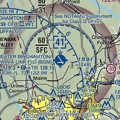
|
 Download PDF
of official airport diagram from the FAA
| Airport distance calculator |
|---|
|
|
| Sunrise and sunset |
|---|
|
Times for 14-Dec-2025
| | Local
(UTC-5) | | Zulu
(UTC) |
|---|
| Morning civil twilight | | 06:54 | | 11:54 |
| Sunrise | | 07:26 | | 12:26 |
| Sunset | | 16:31 | | 21:31 |
| Evening civil twilight | | 17:03 | | 22:03 |
|
| Current date and time |
|---|
| Zulu (UTC) | 15-Dec-2025 01:53:05 |
|---|
| Local (UTC-5) | 14-Dec-2025 20:53:05 |
|---|
|
| METAR |
|---|
| KBGM | 150119Z AUTO 32010KT 3SM BR SCT018 BKN023 OVC028 M12/M14 A3007 RMK AO2 PK WND 30026/0100 T11171139 PWINO FZRANO
|
|
| TAF |
|---|
| KBGM | 141745Z 1418/1518 30011G22KT P6SM BKN080 FM142000 30011G22KT 3SM -SHSN BKN025 TEMPO 1420/1422 2SM -SHSN BR OVC015 FM150500 31010G19KT P6SM BKN015 FM151200 28008KT P6SM BKN020
|
|
| NOTAMs |
|---|
NOTAMs are issued by the DoD/FAA and will open in a separate window not controlled by AirNav.
|
|


