FAA INFORMATION EFFECTIVE 18 APRIL 2024
Location
| FAA Identifier: | BIG |
| Lat/Long: | 63-59-42.5857N 145-43-12.1993W
63-59.709762N 145-43.203322W
63.9951627,-145.7200554
(estimated) |
| Elevation: | 1285.2 ft. / 391.7 m (surveyed) |
| Variation: | 23E (2005) |
| From city: | 3 miles S of DELTA JUNCTION FT GREELY, AK |
| Time zone: | UTC -8 (UTC -9 during Standard Time) |
| Zip code: | 99737 |
Airport Operations
| Airport use: | Private use. Permission required prior to landing |
| Control tower: | yes |
| ARTCC: | ANCHORAGE CENTER |
| FSS: | FAIRBANKS FLIGHT SERVICE STATION [907-474-0788] |
| NOTAMs facility: | BIG (NOTAM-D service available) |
| Attendance: | MON-FRI 1715-0100Z++
CLSD FED HOLS. |
| Wind indicator: | yes |
| Segmented circle: | yes |
| Lights: | ACTVT PAPI RWY 01, 19, 10 & 28; HIRL RWY 01/19 & 10/28; MIRL RWY 07/25 - CTAF. |
| Beacon: | white-green (lighted land airport)
Operates sunset to sunrise. |
Airport Communications
| CTAF: | 122.9 |
| ATIS: | 132.075 |
| WX ASOS: | 135.65 (907-869-3480) |
| ALLEN TOWER GROUND: | 118.225 251.05 [1715- 0100Z++ MON-FRI EXCP FED HOLS.] |
| ALLEN TOWER TOWER: | 119.8 235.775 [1715- 0100Z++ MON-FRI EXCP FED HOLS.] |
| EMERG: | 40.8 ;FM LCL EMERG |
| OPS: | 122.9 |
- APCH/DEP SVC PRVDD BY ANCHORAGE ARTCC ON FREQS 135.3/322.5 (BIG DELTA RCAG).
- COMMUNICATIONS PRVDD BY FAIRBANKS FSS ON FREQ 122.20 (BIG DELTA RCO).
- PRIOR TO ARR, DEP OR SPL REQS CTC BASE OPS - CTAF.
Nearby radio navigation aids
| VOR radial/distance | | VOR name | | Freq | | Var |
|---|
| BIG at field | | BIG DELTA VORTAC | | 114.90 | | 23E |
| NDB name | | Hdg/Dist | | Freq | | Var | | ID |
|---|
| DELTA JUNCTION | | 187/1.9 | | 347 | | 20E | | DJN | -.. .--- -. |
Airport Services
| Fuel available: | J8
J8:CIV FUEL NA. |
| Oil available: | WHEN ATCT CLSD RPRT PSN - CTAF. |
| Parking: | hangars |
Runway Information
Runway 1/19
| Dimensions: | 9000 x 150 ft. / 2743 x 46 m |
| Surface: | asphalt, in good condition |
| Weight bearing capacity: | |
| Runway edge lights: | high intensity |
| RUNWAY 1 | | RUNWAY 19 |
| Latitude: | 63-59.182333N | | 64-00.464000N |
| Longitude: | 145-44.111833W | | 145-42.443000W |
| Elevation: | 1285.2 ft. | | 1219.6 ft. |
| Traffic pattern: | left | | right |
| Runway heading: | 007 magnetic, 030 true | | 187 magnetic, 210 true |
| Displaced threshold: | 1000 ft. | | 1088 ft. |
| Markings: | nonprecision, in good condition | | nonprecision, in good condition |
| Visual slope indicator: | 4-light PAPI on left (3.00 degrees glide path) | | 4-light PAPI on left (3.00 degrees glide path) |
| Touchdown point: | yes, no lights | | yes, no lights |
Runway 10/28
| Dimensions: | 6115 x 150 ft. / 1864 x 46 m |
| Surface: | asphalt, in good condition |
| Weight bearing capacity: | |
| Runway edge lights: | high intensity |
| RUNWAY 10 | | RUNWAY 28 |
| Latitude: | 63-59.982667N | | 63-59.413333N |
| Longitude: | 145-44.129167W | | 145-42.248000W |
| Elevation: | 1253.8 ft. | | 1256.3 ft. |
| Traffic pattern: | left | | left |
| Runway heading: | 102 magnetic, 125 true | | 282 magnetic, 305 true |
| Markings: | precision, in good condition | | precision, in good condition |
| Visual slope indicator: | 4-light PAPI on left (3.00 degrees glide path) | | 4-light PAPI on left (3.00 degrees glide path) |
| Runway end identifier lights: | yes | | yes |
| Touchdown point: | yes, no lights | | yes, no lights |
| Instrument approach: | ILS/DME | | |
Runway 7/25
| Dimensions: | 4057 x 88 ft. / 1237 x 27 m |
| Surface: | asphalt, in good condition |
| Weight bearing capacity: | |
| Runway edge lights: | medium intensity |
| Operational restrictions: | LRG & HVY TKOF NA. |
| RUNWAY 7 | | RUNWAY 25 |
| Latitude: | 63-59.488000N | | 63-59.463833N |
| Longitude: | 145-43.818500W | | 145-42.303833W |
| Elevation: | 1267.9 ft. | | 1257.1 ft. |
| Traffic pattern: | left | | right |
| Runway heading: | 069 magnetic, 092 true | | 249 magnetic, 272 true |
| Markings: | nonprecision, in good condition | | nonprecision, in good condition |
| Touchdown point: | yes, no lights | | yes, no lights |
Airport Ownership and Management from official FAA records
| Ownership: | U.S. Army |
| Owner: | U.S. ARMY
U.S. ARMY FORCES COMMAND
ATLANTA, GA |
| Manager: | HQ 172 INFANTRY BRIGADE
FT RICHARDSON
ALASKA 99505
Phone 907-873-7400 |
Airport Operational Statistics
| Aircraft based on the field: | | 3 | | Helicopters: | | 3 |
| |  | |
| Aircraft operations: avg 80/day * | | 91% | military | | 5% | transient general aviation | | 4% | local general aviation | | * for 12-month period ending 03 January 1984 | |
Additional Remarks
| A39-01/19 | INTXN TWY A & PORTION S OF RWY 07/25 PCN 38. |
| A30A-01 | GND MNVR TRNG ON HAMMERHEAD/KEYHOLE NA. |
| A30A-19 | LRG & HVY TKOF & ENG RUNUPS BFR DTHR NA. |
| - | MIL RAMP OPS PPR. |
| - | WT RSTRN IN EFCT DURG NON WINTER MONTHS; NO WT RSTRN DURG WINTER MONTHS. |
| - | BIRDS ON & INVOF RWY. |
| - | AVOID OVERFLIGHT OF MAIN POST AREA & AMMUNITION STORAGE AREA 1.5 MI SE. |
| - | ARPT COND VIA NOTAM EXC HOL & WKEND. |
| - | AFT HR - DISPATCH C907-873-3288. |
| - | JASU; 2 (CE-13) 1 AIR STARTS (CA-1). |
| - | ISABEL PASS AND BLACK RAPIDS WX CAMERA AVBL ON INTERNET AT HTTPS://WEATHERCAMS.FAA.GOV |
| - | WX OBS AVBL OTR TIMES - 17TH OWS JOINT BASE PEARL HARBOR-HICKAM D315-449-8333/7950/C808-449-8333/7950. |
| - | FLIGHT OPS MON-FRI 1700-0900Z++ EXC FED HOL. |
| - | C130 OR LRGR 180 DEG TURN AROUND NA EXC CONC PORTION OF RWY 01/19 1 MAY-1 NOV. |
| - | ALL OPS 24 HR PPR; NO EARLIER THAN 5 DAYS; D317-873-4170/4171/C907-873-4170/4171; AFT HR - LVE MSG. |
| - | MAIN APRON PCN 31 F/A/W/T. TWY A PCN 57 F/A/W/T; TWY B PCN 42 F/A/W/T; TWY C PCN 68 F/A/W/T; TWY D PCN 44 F/A/W/T. |
| - | HOVER TAXI OVR APRON/RAMP ACES SODDED AREA NA. |
| - | OBSTN: 10 FT FENCE 119 FT FM TAX LINE ALG S EDGE OF TWY D. |
| - | CIV PRKG AVBL WITH CALP; W SIDE OF HNGR. |
| - | LCL WX OBS 0600-2130 - BIG DELTA WX C907-873-4401 OR CTAF. |
| - | 3 CTLD FIRING RANGES, 7 DROP ZONES & RSTRD AREA WI 35 NM; STATUS AVBL - FT GREELY RANGE CTL D873-4714/4715/C907-873-4714/4715. |
| - | GWT RWY 07/25 - ST127. GWT RWY 01/19 - ST127. |
Instrument Procedures
NOTE: All procedures below are presented as PDF files. If you need a reader for these files, you should download the free Adobe Reader.NOT FOR NAVIGATION. Please procure official charts for flight.
FAA instrument procedures published for use from 18 April 2024 at 0901Z to 16 May 2024 at 0900Z.
IAPs - Instrument Approach Procedures |
|---|
| ILS OR LOC/DME RWY 10 | |
download (165KB) |
| RNAV (GPS) RWY 10 | |
download (143KB) |
| RNAV (GPS) RWY 19 | |
download (182KB) |
| VOR/DME OR TACAN RWY 19 | |
download (143KB) |
| VOR RWY 19 | |
download (193KB) |
| NDB-A | |
download (198KB) |
| NOTE: Special Alternate Minimums apply | |
download (103KB) |
| NOTE: Special Take-Off Minimums/Departure Procedures apply | |
download (409KB) |
Other nearby airports with instrument procedures:
PAEI - Eielson Air Force Base (54 nm NW)
PAFB - Ladd Army Airfield (70 nm NW)
PAFA - Fairbanks International Airport (74 nm NW)
PFTO - Tok Junction Airport (84 nm SE)
PAHV - Healy River Airport (86 nm W)
|
|

Road maps at:
MapQuest
Bing
Google
| Aerial photo |
|---|
WARNING: Photo may not be current or correct
 As seen circa 2007
Do you have a better or more recent aerial photo of Allen Army Airfield that you would like to share? If so, please send us your photo.
|
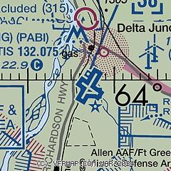
| Sectional chart |
|---|
|
| Airport distance calculator |
|---|
|
|
| Sunrise and sunset |
|---|
|
Times for 23-Apr-2024
| | Local
(UTC-8) | | Zulu
(UTC) |
|---|
| Morning civil twilight | | 04:39 | | 12:39 |
| Sunrise | | 05:40 | | 13:40 |
| Sunset | | 21:42 | | 05:42 |
| Evening civil twilight | | 22:43 | | 06:43 |
|
| Current date and time |
|---|
| Zulu (UTC) | 23-Apr-2024 17:56:55 |
|---|
| Local (UTC-8) | 23-Apr-2024 09:56:55 |
|---|
|
| METAR |
|---|
| PABI | 231653Z 21005KT 10SM SCT060 SCT090 OVC180 03/M06 A2994 RMK AO2 SLP154 VIRGA DSNT N T00281061
|
|
| TAF |
|---|
| PABI | 231400Z 2314/2420 VRB06KT 9999 SCT020 OVC025 QNH2994INS BECMG 2317/2318 VRB06KT 9999 SCT030 BKN040 BKN055 QNH2982INS TX08/2401Z TN00/2414Z
|
|
| NOTAMs |
|---|
NOTAMs are issued by the DoD/FAA and will open in a separate window not controlled by AirNav.
|
|

