FAA INFORMATION EFFECTIVE 30 OCTOBER 2025
Location
| FAA Identifier: | BIS |
| Lat/Long: | 46-46-21.8420N 100-44-44.6550W
46-46.364033N 100-44.744250W
46.7727339,-100.7457375
(estimated) |
| Elevation: | 1661.3 ft. / 506.4 m (surveyed) |
| Variation: | 07E (2010) |
| From city: | 3 miles SE of BISMARCK, ND |
| Time zone: | UTC -6 (UTC -5 during Daylight Saving Time) |
| Zip code: | 58504 |
Airport Operations
| Airport use: | Open to the public |
| Activation date: | 12/1937 |
| Control tower: | yes |
| ARTCC: | MINNEAPOLIS CENTER |
| FSS: | GRAND FORKS FLIGHT SERVICE STATION |
| NOTAMs facility: | BIS (NOTAM-D service available) |
| Attendance: | CONTINUOUS |
| Wind indicator: | lighted |
| Segmented circle: | no |
| Lights: | WHEN ATCT CLSD HIRL RYS 13/31 & 03/21 PRESET MED INTST; PAPI RYS 13; 31; 03; & 21 ON; ACTVT MALS RY 13 & MALSR RY 31 - CTAF. |
| Beacon: | white-green (lighted land airport)
Operates sunset to sunrise. |
| Fire and rescue: | ARFF index B |
Airport Communications
| CTAF: | 118.3 |
| UNICOM: | 122.95 |
| ATIS: | 119.35 |
| WX ASOS: | PHONE 701-922-9747 |
| BISMARCK GROUND: | 121.9 [0600-2400] |
| BISMARCK TOWER: | 118.3 257.8 [0600-2400] |
| BISMARCK APPROACH: | 126.3 298.9 [0600-2400] |
| BISMARCK DEPARTURE: | 126.3 298.9 [0600-2400] |
| ARNG OPS: | 134.1 340.1 49.8FM |
| EMERG: | 121.5 243.0 |
| WX AWOS-3 at Y19 (6 nm W): | 118.225 (701-663-0271) |
- APCH/DEP SVC PRVDD BY MINNEAPOLIS ARTCC ON FREQS 135.25/256.7 (WOODWORTH RCAG) WHEN APCH CLSD.
- NATIONAL GUARD OPERATIONS 0630-1500 MON-FRI; EXCEPT HOL; OTHER TIMES PRIOR PERMISSION REQUIRED V362-2160.
Nearby radio navigation aids
| VOR radial/distance | | VOR name | | Freq | | Var |
|---|
| BISr269/3.4 | | BISMARCK VOR/DME | | 115.65 | | 12E |
Airport Services
| Fuel available: | 100LL JET-A
100LL:FOR FUEL CALL 701-223-4754 OR 701-258-5024. |
| Parking: | hangars and tiedowns |
| Airframe service: | MAJOR |
| Powerplant service: | MAJOR |
| Bottled oxygen: | NONE |
| Bulk oxygen: | HIGH/LOW |
Runway Information
Runway 13/31
| Dimensions: | 8794 x 150 ft. / 2680 x 46 m |
| Surface: | asphalt/concrete/grooved, in good condition |
| Weight bearing capacity: | | PCN 100/R/B/X/T | | Single wheel: | 130.0 | | Double wheel: | 180.0 | | Double tandem: | 340.0 |
|
| Runway edge lights: | high intensity |
| RUNWAY 13 | | RUNWAY 31 |
| Latitude: | 46-47.037158N | | 46-45.969060N |
| Longitude: | 100-45.707173W | | 100-44.287178W |
| Elevation: | 1654.6 ft. | | 1645.2 ft. |
| Traffic pattern: | left | | left |
| Runway heading: | 131 magnetic, 138 true | | 311 magnetic, 318 true |
| Declared distances: | TORA:8794 TODA:8794 ASDA:8794 LDA:8794 | | TORA:8794 TODA:8794 ASDA:8794 LDA:8794 |
| Markings: | precision, in good condition | | precision, in good condition |
| Visual slope indicator: | 4-light PAPI on left (3.00 degrees glide path) | | 4-light PAPI on left (3.00 degrees glide path) |
| RVR equipment: | rollout | | touchdown |
| Approach lights: | MALS: 1,400 foot medium intensity approach lighting system | | MALSR: 1,400 foot medium intensity approach lighting system with runway alignment indicator lights |
| Runway end identifier lights: | no | | no |
| Touchdown point: | yes, no lights | | yes, no lights |
| Instrument approach: | ILS | | ILS/DME |
| Obstructions: | 43 ft. pole, lighted, 1662 ft. from runway, 688 ft. left of centerline, 34:1 slope to clear | | none |
Runway 3/21
| Dimensions: | 6600 x 100 ft. / 2012 x 30 m |
| Surface: | asphalt/grooved, in good condition |
| Weight bearing capacity: | | PCN 26 /F/A/W/T | | Single wheel: | 130.0 | | Double wheel: | 180.0 | | Double tandem: | 340.0 |
|
| Runway edge lights: | high intensity |
| RUNWAY 3 | | RUNWAY 21 |
| Latitude: | 46-45.757023N | | 46-46.600292N |
| Longitude: | 100-44.904925W | | 100-43.909772W |
| Elevation: | 1660.6 ft. | | 1661.3 ft. |
| Traffic pattern: | left | | left |
| Runway heading: | 032 magnetic, 039 true | | 212 magnetic, 219 true |
| Declared distances: | TORA:6600 TODA:6600 ASDA:6600 LDA:6600 | | TORA:6600 TODA:6600 ASDA:6600 LDA:6600 |
| Markings: | precision, in good condition | | precision, in good condition |
| Visual slope indicator: | 4-light PAPI on left (3.00 degrees glide path) | | 4-light PAPI on left (3.00 degrees glide path) |
| Runway end identifier lights: | yes | | yes |
| Touchdown point: | yes, no lights | | yes, no lights |
Airport Ownership and Management from official FAA records
| Ownership: | Publicly-owned |
| Owner: | CITY OF BISMARCK
BOX 991
BISMARCK, ND 58502
Phone 701-355-1808 |
| Manager: | GREGORY B HAUG
BOX 991
BISMARCK, ND 58502-0991
Phone 701-355-1808
24HR CONTACT: OPERATIONS 701-220-9885. |
Additional Remarks
| A30A-21 | RESA NSTD. |
| A30A-03 | RESA NSTD. |
| - | DEER, COYOTES & BIRDS ON & INVOF ARPT. |
| - | RMKS-ARNG: OPR 1200-2130Z++ MON-FRI EXC HOL, PPR 24 PN RQR DSN 373-4071/70, C701-3334071/70. FW PAX TRML LCTD IN 'SE' HGR. |
| - | FOR CD IF UNA TO CTC ON FSS FREQ, CTC MINNEAPOLIS ARTCC AT 651-463-5588. |
Instrument Procedures
NOTE: All procedures below are presented as PDF files. If you need a reader for these files, you should download the free Adobe Reader.NOT FOR NAVIGATION. Please procure official charts for flight.
FAA instrument procedures published for use from 30 October 2025 at 0901Z to 27 November 2025 at 0900Z.
IAPs - Instrument Approach Procedures |
|---|
| ILS OR LOC RWY 13 | |
download (279KB) |
| ILS OR LOC RWY 31 | |
download (304KB) |
| RNAV (GPS) RWY 03 | |
download (236KB) |
| RNAV (GPS) RWY 13 | |
download (238KB) |
| RNAV (GPS) RWY 21 | |
download (223KB) |
| RNAV (GPS) RWY 31 | |
download (249KB) |
| VOR-A | |
download (199KB) |
| Radar Approach Procedures available | |
download (152KB) |
| NOTE: Special Alternate Minimums apply | |
download (151KB) |
| NOTE: Special Take-Off Minimums/Departure Procedures apply | |
download (156KB) |
Other nearby airports with instrument procedures:
Y19 - Mandan Regional Airport/Lawler Field (6 nm W)
7L2 - Linton Municipal Airport (39 nm SE)
D57 - Glen Ullin Regional Airport (46 nm W)
KHZE - Mercer County Regional Airport (46 nm NW)
D05 - Garrison Municipal Airport (60 nm NW)
|
|

Road maps at:
MapQuest
Bing
Google
| Aerial photo |
|---|
WARNING: Photo may not be current or correct
 Photo taken 10-Jun-2010
Do you have a better or more recent aerial photo of Bismarck Municipal Airport that you would like to share? If so, please send us your photo.
|
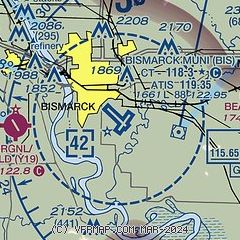
| Sectional chart |
|---|
|
CAUTION: Diagram may not be current
 Download PDF
of official airport diagram from the FAA
| Airport distance calculator |
|---|
|
|
| Sunrise and sunset |
|---|
|
Times for 03-Nov-2025
| | Local
(UTC-6) | | Zulu
(UTC) |
|---|
| Morning civil twilight | | 06:57 | | 12:57 |
| Sunrise | | 07:29 | | 13:29 |
| Sunset | | 17:24 | | 23:24 |
| Evening civil twilight | | 17:56 | | 23:56 |
|
| Current date and time |
|---|
| Zulu (UTC) | 03-Nov-2025 23:09:21 |
|---|
| Local (UTC-6) | 03-Nov-2025 17:09:21 |
|---|
|
| METAR |
|---|
| KBIS | 032252Z AUTO 06005KT 10SM CLR 09/M05 A3012 RMK AO2 SLP214 T00941050
|
KY19
6nm W | 032255Z AUTO 05004KT 10SM 09/M03 A3012 RMK AO2
|
|
| TAF |
|---|
| KBIS | 031720Z 0318/0418 29013KT P6SM SKC FM032000 26008KT P6SM BKN250 FM040000 VRB03KT P6SM SCT250 FM040600 09005KT P6SM BKN200
|
|
| NOTAMs |
|---|
NOTAMs are issued by the DoD/FAA and will open in a separate window not controlled by AirNav.
|
|


