FAA INFORMATION EFFECTIVE 16 APRIL 2026
Location
| FAA Identifier: | BKS |
| Lat/Long: | 27-12-21.8000N 098-07-15.7000W
27-12.363333N 098-07.261667W
27.2060556,-98.1210278
(estimated) |
| Elevation: | 111.7 ft. / 34.0 m (surveyed) |
| Variation: | 06E (2000) |
| From city: | 2 miles SE of FALFURRIAS, TX |
| Time zone: | UTC -5 (UTC -6 during Standard Time) |
| Zip code: | 78355 |
Airport Operations
| Airport use: | Open to the public |
| Activation date: | 09/1949 |
| Control tower: | no |
| ARTCC: | HOUSTON CENTER |
| FSS: | SAN ANGELO FLIGHT SERVICE STATION |
| NOTAMs facility: | BKS (NOTAM-D service available) |
| Attendance: | MAR-OCT MON-FRI 0900-1600, NOV-FEB 0900-1700
FOR ATTENDANT AFT HRS CALL 361-325-2909. |
| Wind indicator: | lighted |
| Segmented circle: | yes |
| Lights: | MIRL RWY 17/35 PRESET LOW INTST. TO INCR INTST & ACTVT REIL RWY 17; PAPI RWYS 17 & 35 - CTAF. |
| Beacon: | white-green (lighted land airport)
Operates sunset to sunrise. |
Airport Communications
| CTAF/UNICOM: | 122.8 |
| WX AWOS-3PT: | 118.125 (361-325-4055) |
| KINGSVILLE APPROACH: | 119.9 |
| KINGSVILLE DEPARTURE: | 119.9 |
- APCH/DEP SVC PRVDD BY HOUSTON ARTCC (ZHU) ON FREQS 128.15/350.3 (SARITA RCAG) WHEN KINGSVILLE APCH CLSD.
Nearby radio navigation aids
| VOR radial/distance | | VOR name | | Freq | | Var |
|---|
| ALIr183/(32.5) | | ALICE VOR | | 114.50 | | 06E |
Airport Services
| Fuel available: | 100LL JET-A |
| Parking: | tiedowns |
| Airframe service: | NONE |
| Powerplant service: | NONE |
| Bottled oxygen: | NONE |
| Bulk oxygen: | NONE |
Runway Information
Runway 17/35
| Dimensions: | 6006 x 75 ft. / 1831 x 23 m |
| Surface: | asphalt, in good condition |
| Weight bearing capacity: | | Single wheel: | 52.0 | | Double wheel: | 80.0 |
|
| Runway edge lights: | medium intensity |
| RUNWAY 17 | | RUNWAY 35 |
| Latitude: | 27-12.876975N | | 27-11.885692N |
| Longitude: | 098-07.207527W | | 098-07.205672W |
| Elevation: | 111.4 ft. | | 110.7 ft. |
| Traffic pattern: | left | | left |
| Runway heading: | 174 magnetic, 180 true | | 354 magnetic, 360 true |
| Markings: | nonprecision, in fair condition | | nonprecision, in fair condition |
| Visual slope indicator: | 4-light PAPI on left (3.00 degrees glide path) | | 4-light PAPI on left (3.00 degrees glide path) |
| Runway end identifier lights: | yes | | |
| Touchdown point: | yes, no lights | | yes, no lights |
| Obstructions: | 36 ft. tree, 1046 ft. from runway, 415 ft. left and right of centerline, 23:1 slope to clear | | none |
Runway 14/32
| Dimensions: | 3018 x 60 ft. / 920 x 18 m |
| Surface: | asphalt, in excellent condition |
| Weight bearing capacity: | |
| RUNWAY 14 | | RUNWAY 32 |
| Latitude: | 27-12.540358N | | 27-12.111335N |
| Longitude: | 098-07.514890W | | 098-07.231747W |
| Elevation: | 110.8 ft. | | 110.8 ft. |
| Traffic pattern: | left | | left |
| Runway heading: | 143 magnetic, 149 true | | 323 magnetic, 329 true |
| Markings: | nonprecision, in fair condition | | nonprecision, in fair condition |
| Touchdown point: | yes, no lights | | yes, no lights |
| Obstructions: | 25 ft. trees, 450 ft. from runway, 100 ft. left of centerline, 10:1 slope to clear | | none |
Airport Ownership and Management from official FAA records
| Ownership: | Publicly-owned |
| Owner: | BROOKS COUNTY
CO COMMISSIONERS COURT
FALFURRIAS, TX 78355
Phone 361-325-5604 |
| Manager: | BOND COSBY
PO BOX 556
FALFURRIAS, TX 78355
Phone 361-325-2909
361-850-3430 OR FROM NOV-FEB ON CALL 24/7 |
Additional Remarks
| - | 9 FT FENCE LCTD APRX 900 FT NORTH OF RWY 17. |
| - | FOR CD CTC HOUSTON ARTCC AT 281-230-5622. |
Instrument Procedures
NOTE: All procedures below are presented as PDF files. If you need a reader for these files, you should download the free Adobe Reader.NOT FOR NAVIGATION. Please procure official charts for flight.
FAA instrument procedures published for use from 16 April 2026 at 0901Z to 14 May 2026 at 0900Z.
IAPs - Instrument Approach Procedures |
|---|
| RNAV (GPS) RWY 17 **CHANGED** | |
download (213KB) |
| RNAV (GPS) RWY 35 **CHANGED** | |
download (215KB) |
| NOTE: Special Alternate Minimums apply | |
download |
| NOTE: Special Take-Off Minimums/Departure Procedures apply | |
download (105KB) |
Other nearby airports with instrument procedures:
KIKG - Kleberg County Airport (21 nm N)
KNQI - Kingsville Naval Air Station (24 nm NE)
KALI - Alice International Airport (32 nm N)
KHBV - Jim Hogg County Airport (34 nm W)
KRBO - Nueces County Airport (41 nm NE)
|
|

Road maps at:
MapQuest
Bing
Google
| Aerial photo |
|---|
WARNING: Photo may not be current or correct
 Photo by Anse Windham
Photo taken 05-May-2014
looking northwest.
Photo by Anse Windham
Photo taken 05-May-2014
looking northwest.
Do you have a better or more recent aerial photo of Brooks County Airport that you would like to share? If so, please send us your photo.
|
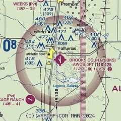
| Sectional chart |
|---|
|
| Airport distance calculator |
|---|
|
|
| Sunrise and sunset |
|---|
|
Times for 22-Apr-2026
| | Local
(UTC-5) | | Zulu
(UTC) |
|---|
| Morning civil twilight | | 06:38 | | 11:38 |
| Sunrise | | 07:02 | | 12:02 |
| Sunset | | 20:00 | | 01:00 |
| Evening civil twilight | | 20:24 | | 01:24 |
|
| Current date and time |
|---|
| Zulu (UTC) | 22-Apr-2026 06:21:41 |
|---|
| Local (UTC-5) | 22-Apr-2026 01:21:41 |
|---|
|
| METAR |
|---|
| KBKS | 220555Z AUTO 15006KT 10SM BKN012 BKN055 OVC070 23/22 A3003 RMK AO2 T02300220 $
|
|
| TAF |
|---|
KNQI
24nm NE | 212200Z 2123/2223 13011KT 9999 VCSH SCT020 BKN050 BKN250 QNH2998INS TEMPO 2123/2205 13012G20KT 9000 -SHRA SCT012 BKN020 OVC050 FM220600 15008KT 9999 VCSH SCT008 OVC015 QNH3000INS FM220800 12005KT 9999 -RA BKN008 OVC015 QNH2999INS FM221400 15010KT 9000 -RA BR SCT015 BKN025 BKN250 QNH2998INS FM221800 13014G20KT 9999 VCSH SCT025 BKN035 BKN250 QNH2990INS AUTOMATED SENSOR METWATCH 2205 TIL 2212 TX28/2220Z TN21/2212Z FN20081
|
|
| NOTAMs |
|---|
NOTAMs are issued by the DoD/FAA and will open in a separate window not controlled by AirNav.
|
|

