FAA INFORMATION EFFECTIVE 27 NOVEMBER 2025
Location
| FAA Identifier: | BLH |
| Lat/Long: | 33-37-09.0000N 114-43-00.8000W
33-37.150000N 114-43.013333W
33.6191667,-114.7168889
(estimated) |
| Elevation: | 399.6 ft. / 121.8 m (surveyed) |
| Variation: | 13E (2005) |
| From city: | 6 miles W of BLYTHE, CA |
| Time zone: | UTC -8 (UTC -7 during Daylight Saving Time) |
| Zip code: | 92225 |
Airport Operations
| Airport use: | Open to the public |
| Activation date: | 04/1940 |
| Control tower: | no |
| ARTCC: | LOS ANGELES CENTER |
| FSS: | RIVERSIDE FLIGHT SERVICE STATION |
| NOTAMs facility: | BLH (NOTAM-D service available) |
| Attendance: | APR-OCT 0700-1600, NOV-MAR 0800-1700 |
| Pattern altitude: | 1199.6 ft. MSL |
| Wind indicator: | lighted |
| Segmented circle: | yes |
| Lights: | ACTVT VASI RWY 17, 35 & 26; MIRL RWY 17/35 & 08/26 - CTAF |
| Beacon: | white-green (lighted land airport)
Operates sunset to sunrise. |
Airport Communications
| CTAF/UNICOM: | 122.8 |
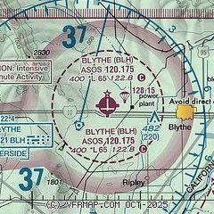
| WX ASOS: | 120.175 (760-922-3000) |
- APCH/DEP CTL SVC PRVDD BY LOS ANGELES ARTCC (ZLA) ON FREQS 128.15/285.6 (LAGUNA RCAG).
Nearby radio navigation aids
| VOR radial/distance | | VOR name | | Freq | | Var |
|---|
| BLHr044/2.6 | | BLYTHE VORTAC | | 117.40 | | 14E |
| PKEr168/29.0 | | PARKER VORTAC | | 117.90 | | 15E |
Airport Services
| Fuel available: | 100LL JET-A |
| Parking: | hangars and tiedowns |
| Airframe service: | NONE |
| Powerplant service: | NONE |
| Bottled oxygen: | NONE |
| Bulk oxygen: | NONE |
Runway Information
Runway 8/26
| Dimensions: | 6543 x 150 ft. / 1994 x 46 m |
| Surface: | asphalt, in fair condition |
| Weight bearing capacity: | | Single wheel: | 80.0 | | Double wheel: | 115.0 | | Double tandem: | 210.0 |
|
| Runway edge lights: | medium intensity |
| RUNWAY 8 | | RUNWAY 26 |
| Latitude: | 33-36.996138N | | 33-36.992222N |
| Longitude: | 114-43.663765W | | 114-42.374400W |
| Elevation: | 397.1 ft. | | 395.7 ft. |
| Traffic pattern: | left | | left |
| Runway heading: | 077 magnetic, 090 true | | 257 magnetic, 270 true |
| Markings: | basic, in good condition | | nonprecision, in fair condition |
| Visual slope indicator: | | | 4-box VASI on left (3.00 degrees glide path) |
| Runway end identifier lights: | no | | no |
| Touchdown point: | yes, no lights | | yes, no lights |
Runway 17/35
| Dimensions: | 5800 x 100 ft. / 1768 x 30 m |
| Surface: | asphalt, in fair condition |
| Weight bearing capacity: | | Single wheel: | 52.0 | | Double wheel: | 76.0 | | Double tandem: | 135.0 |
|
| Runway edge lights: | medium intensity |
| RUNWAY 17 | | RUNWAY 35 |
| Latitude: | 33-37.802097N | | 33-36.845852N |
| Longitude: | 114-43.004505W | | 114-43.009045W |
| Elevation: | 399.2 ft. | | 394.3 ft. |
| Traffic pattern: | left | | left |
| Runway heading: | 167 magnetic, 180 true | | 347 magnetic, 000 true |
| Markings: | basic, in fair condition | | basic, in fair condition |
| Visual slope indicator: | 4-box VASI on left (3.00 degrees glide path) | | 4-box VASI on left (3.00 degrees glide path) |
| Runway end identifier lights: | no | | no |
| Touchdown point: | yes, no lights | | yes, no lights |
Airport Ownership and Management from official FAA records
| Ownership: | Publicly-owned |
| Owner: | COUNTY OF RIVERSIDE
4080 LEMON STREET, 14TH FLOOR
RIVERSIDE, CA 90501
Phone 951-955-9418 |
| Manager: | ANGELA JAMISON
4080 LEMON STREET, 14TH FLOOR
RIVERSIDE, CA 92501
Phone 951-955-9418 |
Additional Remarks
| - | ACFT OVER 12500 LBS AVOID HOUSING AREA 1.5 NM SW BLO 2000' FINAL APCH RWY 35 BE ESTABD 2 NM FM TOUCHDOWN. |
| - | DEP FM RY 17 MAKE CLIMBING LEFT TURN SOON AS SAFETY PERMITS. USE WIDE TFC PATTERN FOR RYS 26 & 35. |
| - | POWER PLANT 1 MILE EAST OF ARPT PRODUCING THERMAL PLUMES; AVOID LOW ALTITUDE DIRECT OVERFLIGHT OF THE POWER PLANT. |
| - | PAJA. PRCHT TRNG HIGH AND LOW LVLS ALL HRS NE QUAD OF ARPT |
| - | FOR CD IF UNA TO CTC ON FSS FREQ, CTC LOS ANGELES ARTCC AT 661-575-2079. |
Instrument Procedures
NOTE: All procedures below are presented as PDF files. If you need a reader for these files, you should download the free Adobe Reader.NOT FOR NAVIGATION. Please procure official charts for flight.
FAA instrument procedures published for use from 27 November 2025 at 0901Z to 25 December 2025 at 0900Z.
IAPs - Instrument Approach Procedures |
|---|
| RNAV (GPS) RWY 26 | |
download (243KB) |
| VOR/DME RWY 26 | |
download (196KB) |
| VOR/DME-A | |
download (180KB) |
| NOTE: Special Alternate Minimums apply | |
download (19KB) |
| NOTE: Special Take-Off Minimums/Departure Procedures apply | |
download (356KB) |
Other nearby airports with instrument procedures:
P20 - Avi Suquilla Airport (39 nm NE)
KLGF - Laguna Army Airfield (Yuma Proving Ground) (48 nm S)
KCLR - Cliff Hatfield Memorial Airport (50 nm SW)
KBWC - Brawley Municipal Airport (55 nm SW)
KNYL - Yuma Marine Corps Air Station/Yuma International Airport (58 nm S)
|
|

Road maps at:
MapQuest
Bing
Google
| Aerial photo |
|---|
WARNING: Photo may not be current or correct
 Photo by Sungsoo Lee
Photo taken 07-Sep-2010
looking southeast.
Photo by Sungsoo Lee
Photo taken 07-Sep-2010
looking southeast.
Do you have a better or more recent aerial photo of Blythe Airport that you would like to share? If so, please send us your photo.
|
| Sectional chart |
|---|
|
| Airport distance calculator |
|---|
|
|
| Sunrise and sunset |
|---|
|
Times for 19-Dec-2025
| | Local
(UTC-8) | | Zulu
(UTC) |
|---|
| Morning civil twilight | | 06:12 | | 14:12 |
| Sunrise | | 06:39 | | 14:39 |
| Sunset | | 16:33 | | 00:33 |
| Evening civil twilight | | 17:00 | | 01:00 |
|
| Current date and time |
|---|
| Zulu (UTC) | 19-Dec-2025 08:41:08 |
|---|
| Local (UTC-8) | 19-Dec-2025 00:41:08 |
|---|
|
| METAR |
|---|
| KBLH | 190752Z AUTO 10003KT 10SM CLR 11/08 A3000 RMK AO2 SLP156 T01110078 402330094 PNO $
|
|
| TAF |
|---|
| KBLH | 190520Z 1906/2006 34006KT P6SM BKN250 FM191400 VRB03KT P6SM SCT250
|
|
| NOTAMs |
|---|
NOTAMs are issued by the DoD/FAA and will open in a separate window not controlled by AirNav.
|
|

