FAA INFORMATION EFFECTIVE 09 JULY 2026
Location
| FAA Identifier: | BTF |
| Lat/Long: | 40-52-05.3369N 111-55-38.9969W
40-52.088948N 111-55.649948W
40.8681491,-111.9274991
(estimated) |
| Elevation: | 4237.1 ft. / 1291.5 m (surveyed) |
| Variation: | 15E (1985) |
| From city: | 3 miles SW of BOUNTIFUL, UT |
| Time zone: | UTC -6 (UTC -7 during Standard Time) |
| Zip code: | 84087 |
Airport Operations
| Airport use: | Open to the public |
| Activation date: | 05/1945 |
| Control tower: | no |
| ARTCC: | SALT LAKE CITY CENTER |
| FSS: | CEDAR CITY FLIGHT SERVICE STATION |
| NOTAMs facility: | CDC (NOTAM-D service available) |
| Attendance: | MON-FRI 0700-1900, ALL SAT-SUN 0800-1700 |
| Pattern altitude: | STD HELI TPA 1000 FT AGL. HELI TPA AMDD TO AGREE WITH ALL ACFT AT 1000 FT AGL. |
| Wind indicator: | lighted |
| Segmented circle: | no |
| Lights: | ACTVT LIRL RWY 17/35 - CTAF. |
| Beacon: | white-green (lighted land airport)
Operates sunset to sunrise. |
| Landing fee: | yes, FOR LNDG FEES, CTC AMGR. |
Airport Communications
| CTAF/UNICOM: | 122.8 |
| CLEARANCE DELIVERY: | 120.7 |
| WX ASOS at SLC (5 nm SW): | 125.625 (801-899-0709) |
| WX AWOS-3PT at SVR (15 nm S): | 134.425 (801-562-0271) |
| WX ASOS at OGD (20 nm N): | PHONE 801-622-5600 |
- SALT LAKE CITY ATCT PROVIDES CD ON FREQ 120.7.
Nearby radio navigation aids
| VOR radial/distance | | VOR name | | Freq | | Var |
|---|
| TCHr051/2.7 | | WASATCH VORTAC | | 116.80 | | 16E |
| OGDr146/22.7 | | OGDEN VORTAC | | 115.70 | | 14E |
| FFUr345/35.6 | | FAIRFIELD VORTAC | | 116.60 | | 16E |
Airport Services
| Fuel available: | 100LL JET-A MOGAS
100LL:100LL & JET A SELF SVC FUEL AVBL 24 HRS WITH CC. |
| Parking: | hangars and tiedowns |
| Airframe service: | MAJOR |
| Powerplant service: | MAJOR |
| Bottled oxygen: | NONE |
| Bulk oxygen: | NONE |
Runway Information
Runway 17/35
| Dimensions: | 4634 x 70 ft. / 1412 x 21 m |
| Surface: | asphalt, in excellent condition |
| Weight bearing capacity: | |
| Runway edge lights: | low intensity |
| Operational restrictions: | ALL DEPS WILL BE TO THE EAST. |
| RUNWAY 17 | | RUNWAY 35 |
| Latitude: | 40-52.470525N | | 40-51.707372N |
| Longitude: | 111-55.651722W | | 111-55.648175W |
| Elevation: | 4236.1 ft. | | 4237.1 ft. |
| Traffic pattern: | left | | right |
| Displaced threshold: | 389 ft. | | 391 ft. |
| Markings: | basic, in good condition | | basic, in good condition |
| Visual slope indicator: | 2-light PAPI on left (3.50 degrees glide path) | | 2-light PAPI on left (3.50 degrees glide path) |
| Obstructions: | 8 ft. fence, 232 ft. from runway, 4:1 slope to clear
8 FT BLDG, 0 FT DSTC, 122 FT LEFT. | | 6 ft. fence, 200 ft. from runway, 90 ft. left of centerline
6 FT FENCE, 0-200 FT DSTC, 94 FT RIGHT. |
Airport Ownership and Management from official FAA records
| Ownership: | Privately-owned |
| Owner: | SKYPARK AIRPORT ASSOC, LLC
1887 S. 1800 W. #2
WOODS CROSS, UT 84087
Phone 801-295-3877 |
| Manager: | CHRIS VOLZER
1887 S. 1800 W., #2
WOODS CROSS, UT 84087
Phone 801-295-3877 |
Additional Remarks
| - | FOR CD CTC SALT LAKE CITY APCH AT 801-325-9670. |
Instrument Procedures
There are no published instrument procedures at KBTF.
Some nearby airports with instrument procedures:
KSLC - Salt Lake City International Airport (5 nm SW)
KSVR - South Valley Regional Airport (15 nm S)
KHIF - Hill Air Force Base (15 nm N)
KOGD - Ogden-Hinckley Airport (20 nm N)
KTVY - Bolinder Field/Tooele Valley Airport (25 nm SW)
|
|

Road maps at:
MapQuest
Bing
Google
| Aerial photo |
|---|
WARNING: Photo may not be current or correct
 Photo taken 25-Oct-2015
looking north.
Photo taken 25-Oct-2015
looking north.
Do you have a better or more recent aerial photo of Skypark Airport that you would like to share? If so, please send us your photo.
|
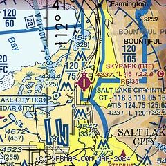
| Sectional chart |
|---|
|
CAUTION: Diagram may not be current

| Airport distance calculator |
|---|
|
|
| Sunrise and sunset |
|---|
|
Times for 01-Aug-2026
| | Local
(UTC-6) | | Zulu
(UTC) |
|---|
| Morning civil twilight | | 05:54 | | 11:54 |
| Sunrise | | 06:25 | | 12:25 |
| Sunset | | 20:43 | | 02:43 |
| Evening civil twilight | | 21:14 | | 03:14 |
|
| Current date and time |
|---|
| Zulu (UTC) | 01-Aug-2026 08:47:12 |
|---|
| Local (UTC-6) | 01-Aug-2026 02:47:12 |
|---|
|
| METAR |
|---|
KSLC
5nm S | 010754Z 31004KT 10SM CLR 26/05 A3009 RMK AO2 SLP121 T02610050 VISNO NW RNWY $
|
KHIF
15nm N | 010755Z AUTO 10013G19KT 10SM CLR 28/M00 A3014 RMK AO2 SLP119 T02771004
|
|
| TAF |
|---|
KSLC
5nm S | 010520Z 0106/0212 15007KT P6SM SKC FM012000 32009KT P6SM SKC FM020400 15006KT P6SM SKC
|
KHIF
15nm N | 010500Z 0105/0211 11012KT 9999 FEW100 QNH3013INS TEMPO 0107/0114 10020G30KT 520009 BECMG 0117/0118 VRB06KT 9999 FEW100 QNH3001INS BECMG 0203/0204 12012G18KT 9999 FEW100 QNH2996INS TX38/0122Z TN22/0113Z
|
|
| NOTAMs |
|---|
NOTAMs are issued by the DoD/FAA and will open in a separate window not controlled by AirNav.
|
|


